|
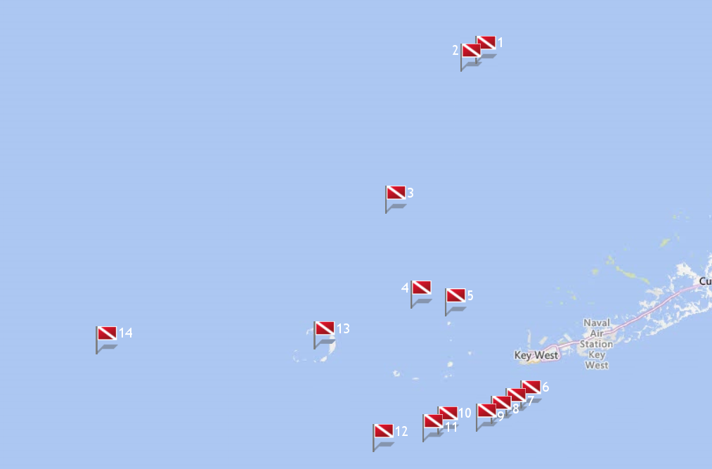
Site Name |
Dive Type |
Difficulty |
GPS |
Max Depth |
Map |
|
1 |
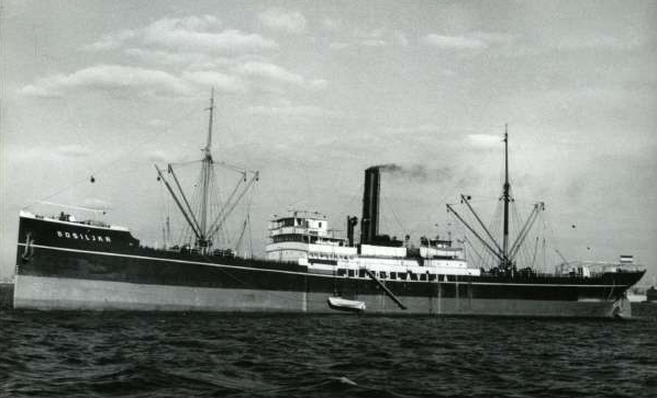
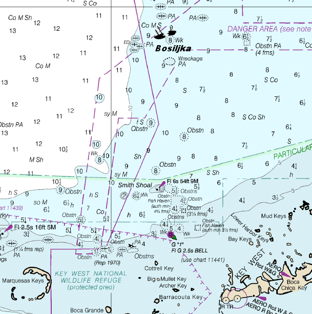
Bosiljka |
Wreck |
Intermediate |
24°58.203 N
81°52.804 W |
65' |
|
| |
Built in 1896 in Glasgow, this 322 foot British steamer started out as the SS Polycarp sailing for the Booth
Steamship Company. In 1912 she was sold to Swedish owners who renamed her SS Augusta, sold again in 1918 and renamed the SS Bia, and then again in 1921 renamed as
the SS Falco. Finally in 1935, she was purchased by a Yugoslavian company and this is when she received her final name, SS Bosiljka.
Four years later,
World War II broke out, and then in 1941, Germany invaded Yugoslavia. The Bosiljka was at sea, and when news of the invasion reached her crew, they panicked. Not
wanting to return to their home port, they committed mutiny and sailed to Brazil. Once she docked, with help from the Brazilian and American governments, the British
were able to seize the vessel. They replaced her mutinous crew with British sailors, and the ship disembarked for New York. With their country in the hands of the
Germans, the Yugoslavian government was no longer in power in their homeland. Instead, they were trying to maintain some form of control by operating out of Britain.
They'd already lost their country, they weren't about to loose their ship too. Once word reached them about the seizure, they swiftly laid claim to the Bosiljka.
After hearing the evidence, the courts held in favor of the defunct government. However, since the Yugoslavs were essentially homeless, the courts allowed
the ship to be operated by the Allies. They used her to help transport important materials to their forces. Since America was fighting a hard battle and was concerned
about being attacked by sea, the US took steps to protect the surrounding waters. Toward that end, the American military laid down mine fields in the Gulf of Mexico
to destroy invading enemy vessels. One large minefield was placed near Smith Shoal. Unfortunately these mine fields proved deadlier to friendly shipping than they did
to the enemy.
Due to miscalculated coordinates, this steamer is just one of the vessel's that sank from an unfortunate encounter with the minefield.
Not only did the Bosiljka meet an unexpected fate at the hand of friendly forces, she was carrying cargo vital to the war effort. Not only are medical supplies usually
in very limited quantity, they're also in the highest demand. This is the precious cargo the Bosiljka carried while en route from New Orleans to Key West when she sank
on June 19, 1942.
Markers - None.
Details - Pharmaceutical bottles are found wreck diving the Bosiljka, and in the debris field around her. Numerous anchors from fishing boats and shrimp boats,
along with fishing lines and nets.
Marine Life - Bluefish, gag and goliath grouper, snapper, shark, cobia, permit, snapper, barracuda.
Recommended Certifications - Open Water, Advanced Open Water, Enriched Air (Nitrox), Boat, Drift, Multi-Level, Peak Performance Buoyancy, Wreck, Coral Reef
Conservation. |
|
|
|
|
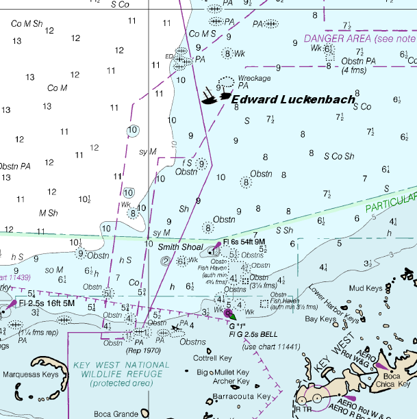
2 |
Edward Luckenbach |
Wreck |
Intermediate |
24°57.831 N
81°53.269 W |
65' |
|
| |
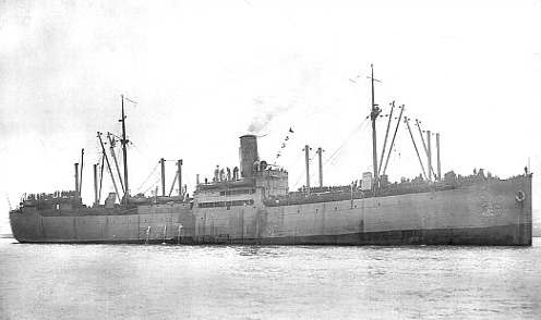
The Edward Luckenbach was another victim of American mine fields laid
in the Gulf of Mexico to thwart enemy vessels. Built in 1916, she was just under 457 feet with a beam of 57 feet. She was used as a cargo freighter and was also the
largest US ship to unwittingly enter this dangerous territory. She was also somewhat unique in that she basically remained under one name and one ownership except for
a brief stint in WWI.
In 1918, her owners, the Luckenbach Steamship Company of New York City, temporarily transferred her to the United States Navy where
she became the USS Edward Luckenbach (ID-1662). In 1919 she was returned to her owners, and resumed her duties as a merchant freighter.
During World
War II, she often transported a variety of vital materials essential to the war effort. It was while she was traveling from Jamaica to New Orleans that she
unknowingly entered the minefield intended to target enemy vessels. The military chose not to notify friendly shipping about the minefield can only be speculated but
the rationale appears to be that if anyone knew about the minefields, they'd be rendered ineffective, hence the saying, "loose lips sink ships".
Without
knowing of the danger that lay ahead, the Edward Luckenback sank on July 2, 1942, carrying an important and expensive cargo. On board she had over 10,000 tons of
tungsten which was vital for the construction of over 15,000 different war items including tanks, shells, trucks and guns. This was estimated to be about 1/6 of the
world's supply and had a current market value of approximately $1,500,000. Her cargo was so important to the Allied success in the war effort that she carried 12
armed naval guards to protect her from hijack or attack.
When she entered the minefield zone, the first one she struck detonated on her port side,
forward of the engine room. This explosion killed the third assistant engineer. Within just a few minutes, she struck a second mine amidships on her port side.
This explosion caused the large freighter to sink in an upright position. Even though the ship was destroyed, Captain Kelly, his remaining 40 crew members, and the
12 armed naval guards all survived.
Her superstructure was still above water when she sank. At 55 feet maximum depth, she was exposed and posed a
danger to shipping. As soon as rescue efforts had been completed, recovery of her cargo began. In particular, her load of tungsten was extremely important. The
real threat of salvagers stealing her precious commodity and selling it on the black market was a concern. In reclaiming the precious metal, the ship had to be
opened up. Once the cargo was removed, the ship was then wire dragged to break her up and bring her below the water's surface so she didn't pose a hazard to
shipping.
Visibility at this wreck is typically poor as you're in the Gulf of Mexico and there's no current at this point to keep the water clear.
Markers - None.
Details - Lies east to west on sandy bottom. Her remains are scattered over a broad area.
Marine Life - Bull shark, permit, gag and goliath grouper, cobia, and mangrove snapper, pompano, barracuda, bluefish, blue runners.
Recommended Certifications - Open Water, Advanced Open Water, Enriched Air (Nitrox), Boat, Drift, Multi-Level, Peak Performance Buoyancy, Wreck, Coral Reef
Conservation. |
|
|
|
|
3 |
 |
Wreck |
Intermediate |
24°45.503 N
82°1.301 W |
65' |
|
| |
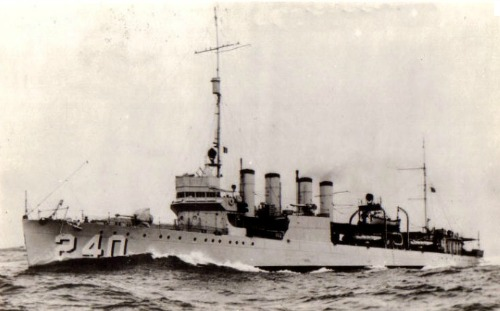
The USS Sturtevant (DD-240) is another victim of American minefields
designed to ward off enemy ships during World War II. She was named in honor of a heroic naval aviator who was killed in World War I. The pilot, Albert D.
Sturtevant died February 15, 1918 while battling a larger group of German planes.
Measuring 314' long with a 30' beam, this 4 stack destroyer was
built the year Sturtevant died. In honor of his heroism, he was posthumously awarded the prestigious Navy Cross, and this ship was christened with his name.
Commissioned on September 21, 1920 she was decked out with four 4 inch guns, one 3 inch anti-aircraft gun, 12 torpedo tubes and 20 millimeter Oerlikon machine guns.
From the moment she was first deployed, she was involved in numerous missions taking her around the globe, from Russia, to Europe, to the Middle East,
and the Caribbean. Whether she was participating in training exercises or peace keeping missions, this destroyer was constantly at work. Then on January 30, 1931,
she was decommissioned for the first time. On March 9, 1932 she was put back into the fleet and on April 30, under the Commander of the Special Service Squadron, she
worked the waters of the Gulf of Mexico and the Caribbean monitoring the troubled nations of South and Central America and the islands of the Caribbean.
In
1934 she was reassigned and joined the destroyers of the Scouting Force until 1935 when she joined the Battle Force in the Pacific. She continued in this capacity
with San Diego being her home port until she was decommissioned again on November 20, 1935. Less than a year later, World War II started and on September 26, 1939 she
was commissioned a third time. Her duties involved escorting convoys moving through the Atlantic, and patrolling America's eastern seaboard.
In
March, 1942, she came under the command of the Caribbean Sea Frontier and was responsible for screening convoys between the different ports of the Caribbean. It was
on April 6, 1942, while performing these duties that she ran into trouble. Barely two hours out of Key West, an explosion forced her stern out of the water. Being
fully operational with no obvious damage, the Captain initiated a counterattack. He believed a torpedo from a German U-boat had fired at them so he ordered a
volley of depth charges. Within a minute of the second depth charge drop, the USS Sturtevant was hit with another explosion. This time the damage was evident, and
the destroyer began to settle quickly.
A few minutes later a third explosion was felt, and this proved fatal. With her keel torn apart below the after deckhouse,
her midships section sank immediately, and her stern followed shortly. In only 65 feet of water, the bow stayed above water for several hours until it finally
disappeared, leaving only the crow's nest visible. Sinking in minutes after enduring 3 explosions, it's a miracle only 15 crew members were killed that day while 152
survived.
There are numerous artifacts on board, including most of her ammunition. Be aware of the fact that the destroyer is still the property of
the United States Navy. This means removal of any item is strictly prohibited. This site is also plagued with fine silt covering the ocean bottom which means
visibility is relatively poor. And remember, the USS Sturtevant is also a grave site.
Markers - None.
Details - Ship is broken into 2 sections, lying on sandy, silty bottom.
Marine Life - Goliath and gag grouper, cobia, shark, snapper, kingfish, permit, bluefish, blue runners, pompanos, tarpon.
Recommended Certifications - Open Water, Advanced Open Water, Enriched Air (Nitrox), Boat, Drift, Multi-Level, Peak Performance Buoyancy, Wreck, Coral Reef
Conservation. |
|
|
|
|
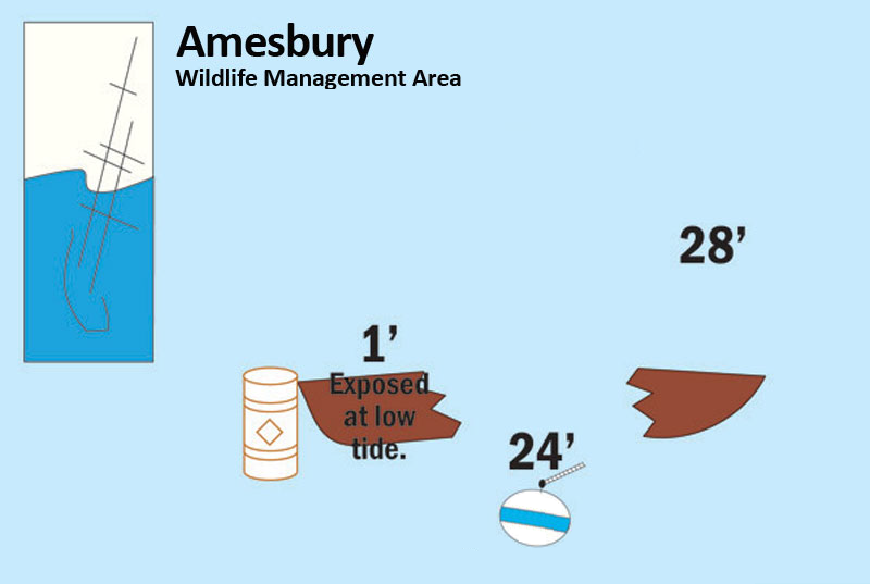
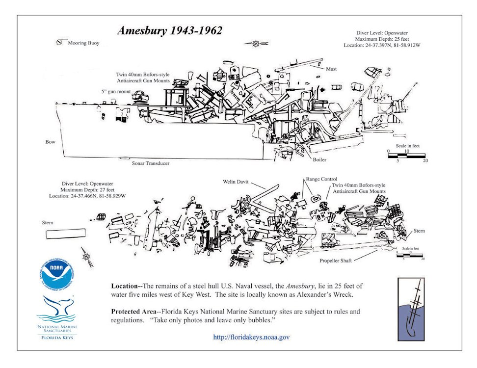
4 |
 |
Wreck |
Novice - Advanced |
24°37.397 N
81°58.912 W |
25' |
|
| |
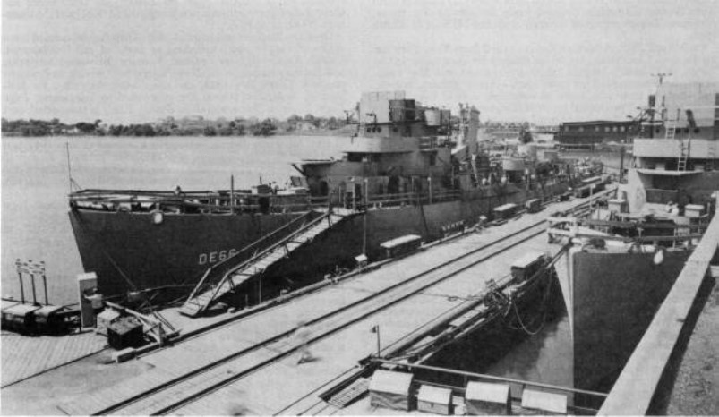
The USS Amesbury (DE-66) was commissioned in 1943 as a
destroyer escort. She was named for Lt. Stanton Amesbury who was killed in enemy action over Casablanca on November 9, 1942, while attached to an aviation squadron in
the Atlantic Area. The Amesbury's first assignment was duty with the Atlantic Convoy 7, followed by participation in the Normandy invasion.
Returning
to the United States in August, 1944, she was assigned temporary duty with the Fleet Sonar School in Key West. In 1945, she was one of the 104 destroyer escorts
converted to high-speed transports at the Philadelphia Navy Yard. The Amesbury was then assigned hull number APD-46 and equipped with a five-inch turret gun and
three twin-mount forty-millimeter BOFORS antiaircraft guns. Proceeding to the Pacific, she supported landings in Korea and China during 1945, carrying Underwater
Demolition Team Twelve.
The Amesbury returned to Florida in 1946, was decommissioned, and never performed active service again. Chet Alexander Marine
Salvage of Key West purchased her in 1962 for scrap. In 1972, Mr. Alexander made plans for this vessel to become an artificial reef in the deep water of the Gulf of
Mexico. While towing the old navy ship to her final resting place, she inadvertently ran aground. Before she could be refloated, a strong storm came through the
Gulf. Her hull was broken in two forever ending the possibility of reaching deeper water.
Markers - None.
Details - The two sections of this ship are lying approximately 200 yards apart. At the south end of the site, you'll encounter the bow and port side. The
five inch gun mount and the twin mount forty-millimeter antiaircraft guns rest about 50 feet behind this section. The stern and starboard side are situated at the
north end and a debris field including sections of the bridge, upper hull and superstructure are on the east side of the hull.
Marine Life - Oysters, sheepshead, larger game fish, snapper, angelfish, barracuda, and goliath grouper.
Recommended Certifications - Open Water, Advanced Open Water, Enriched Air (Nitrox), Boat, Drift, Peak Performance Buoyancy, Wreck, Coral Reef Conservation. |
|
|
|
|
|
5 |
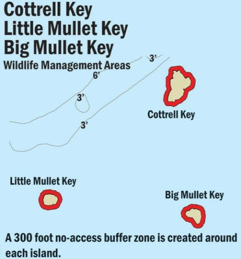
Cottrell Key |
Reef |
Novice |
24°36.740 N
81°55.630 W |
15' |
|
| |
Cottrell Key was named after a 19th century Captain who protected
passing vessels from grounding on the reef. Instead of a lighthouse shining it's warning beacon, he watched over all passersby with his lightship.
Markers - Markers and mooring buoys.
Details - Being on the Gulf side, this coral reef is protected from the wind by the Florida Keys themselves. It starts just west of the old lighthouse and the ledges and fingers
run for approximately 2 miles. The area is quite shallow.
Marine Life - Coral head clusters, yellowtail, parrotfish, sea sponges, cowries, spiny lobster, conchs, hogfish.
Recommended Certifications - Open Water, Advanced Open Water, Enriched Air (Nitrox), Boat, Drift, Peak Performance Buoyancy, Coral Reef Conservation.
|
|
|
6 |
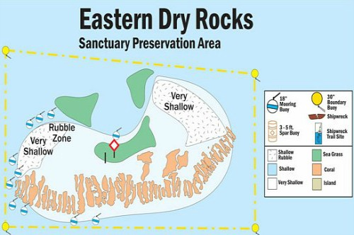
Eastern Dry Rocks |
Reef |
Novice |
24°27.715 N
81°50.801 W |
35' |
|
| |
Eastern Dry Rocks is in an SPA area consisting of a group of bank reefs.
These coral reefs have the typical composition you'll find elsewhere in the region, including rubble zones and long fingers of coral separated by deeper sand and coral
canyons.
Over the centuries, a number of different ships have wrecked upon these reefs. The LW Maxwell, Dwight and Nathaniel Kemball are just three vessels
that wrecked in the mid-1800's. Plus there was a Spanish ship of unknown name carrying tile that grounded here in the 1800's.
Markers - R1 - R11 mooring buoys.
Details - Standard spur and groove with deeper crevices and canyons. Numerous artifacts from various wrecks can be discovered including cannon balls,
ballast stone piles and brass spikes.
Marine Life - Sea turtles, hammerhead and nurse sharks, brain coral, snook, sting ray, cleaner shrimp, reef crabs, octopus, lobsters, permit, moray eel,
parrotfish, angelfish, tarpon, sergeant majors, spotted eagle rays, barracuda, conch.
Recommended Certifications - Open Water, Advanced Open Water, Enriched Air (Nitrox), Boat, Drift, Multi-Level, Peak Performance Buoyancy, Coral Reef Conservation. |
|
|
7 |
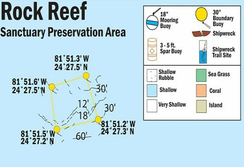
Rock Reef |
Reef |
Novice |
24°27.260 N
81°51.510 W |
35' |
|
| |
Rock Reef is in an SPA area consisting of a group of bank reefs.
These coral reefs have the typical composition you'll find elsewhere in the region, including rubble zones and long fingers of coral separated by deeper sand and coral
canyons. The crevices at Rock Reef are deeper and wider than what is usually found at other coral reefs. These wider openings create the perfect hiding habitat
for grouper, moray eel and other fish.
Over the centuries, a number of different ships have wrecked upon these reefs. The LW Maxwell, Dwight, and
Nathaniel Kemball are just three vessels that wrecked in the mid-1800's. Plus there was a Spanish ship of unknown name carrying tile that grounded here in the 1800's.
Markers - R1 - R11 mooring buoys.
Details - South end of Rock Key is shallow to 1 foot. Standard spur and groove with deeper crevices and canyons. Numerous artifacts from various wrecks can be
discovered including cannon balls, ballast stone piles and brass spikes.
Marine Life - Sea turtles, hammerhead and nurse sharks, brain coral, snook, sting ray, cleaner shrimp, reef crabs, octopus, lobsters, permit, moray eel,
parrotfish, angelfish, tarpon, sergeant majors, spotted eagle rays, barracuda, conch.
Recommended Certifications - Open Water, Advanced Open Water, Enriched Air (Nitrox), Boat, Drift, Multi-Level, Peak Performance Buoyancy, Coral Reef Conservation. |
|
|
8 |
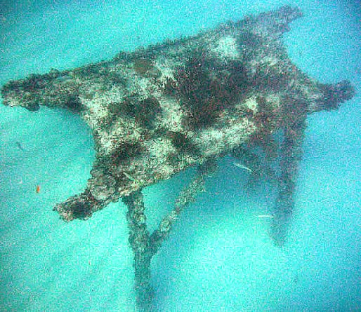
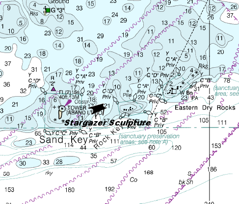
Stargazer Sculpture |
Reef |
Novice |
24°27.320 N
81°51.970 W |
30' |
|
| |
Ann Lorraine Labriola, the inspired Key West artist of the Stargazer
Sculpture, created this amazing piece for several reasons. The first reason behind her artificial reef project, was to help funnel traffic away from the more fragile
coral reefs. By placing her artwork here, she'd help reduce some of the heavy traffic Sand Key experiences from those out of Key West diving and snorkeling. She also
felt that the proximity to Sand Key and Key West would benefit her, by increasing awareness of her project.
The other reason she decided to create this
unique piece of art, was to pay homage to the mariners of old. Before modern technology, a ship's Captain navigated the waters using the stars as their guide. She
designed and cut the shapes of the various constellations into the different steel pieces, paying tribute to these skilled masters of the sea. Her intent was that the
structure be built to resemble a primitive navigational device and be lit from below. This illumination would make the stars that were cut into it's shape, appear to
shine under water.
Since being built and placed in 1992, the marine life began to quickly attach to the individually designed pieces of the sculpture. Over the years,
the statue has become more encrusted. This natural beautification process has increased it's size and added to it's overall shape and character.
This
artificial reef consists of 10 individual steel pieces, each weighing approximately 6 tons and supported by steel legs. These supports keep the pieces elevated above
the ocean floor as they stretch over an area of about 200 feet. The various portions of the statue have also been designed with different forms in mind. Some are flat
resembling a table, and have the shapes of the constellations cut into their surfaces. Another has the shape of a large circle. This piece has cross beams which adds
to it's resemblance of a mandala, a geometric configuration of symbols. This is a very appropriate design choice as these ancient symbols often represent the celestial
circles we call earth, sun, and moon, and include the symbolism of friends, family, and community. Another piece which the artist refers to as "The Arrow" has the Little
Dipper's constellation cut into it's form. This section of the statue points due west, and is raised 5 feet off the ocean floor by it's steel legs.
The
unusual shape Ann Lorraine Labriola created is what draws visitors to the area. It appears even more unusual and spectacular from the air. It has been compared to the
shape of a bird, and even to an unusual looking navigational device, perhaps used by aliens.
Markers - None.
Details - 200 feet of individual pieces comprise the statue. The art form is becoming heavily encrusted with marine life.
Marine Life - Snapper, stony and gorgonian coral, grouper, and goliath grouper, tropical fish, lobsters.
Recommended Certifications - Open Water, Advanced Open Water, Enriched Air (Nitrox), Boat, Drift, Peak Performance Buoyancy, Coral Reef Conservation. |
|
|
|
|
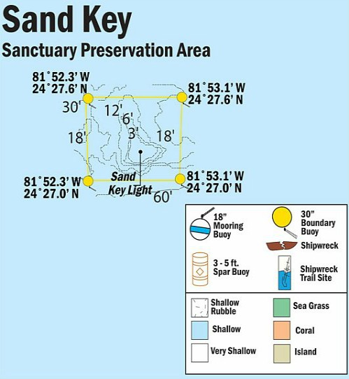
9 |
Sand Key |
Reef |
Novice |
24°27.100 N
81°52.580 W |
90' |
|
| |
Sand Key is different from other coral reefs in the area because it
was originally an island by itself. Due to erosion from Florida hurricanes and other storms, it has been reduced to this very small patch of sand surrounded by coral
reef. The shape of the island changes with the wind and wave action, which makes each trip here totally different. These factors also have a strong impact on
visibility, which can range from poor to very good. The sand is an especially nice feature you don't usually have at other reefs. It actually makes it
possible for you to get out of the water and see things from a different perspective.
If you want a truly amazing view of the area, you can climb the
red iron landmark. This 1853 lighthouse stands 110 feet tall and visitors are allowed to climb it's towering height. From here you'll be rewarded with a spectacular
view of the ocean and Key West far off in the distance.
Markers - 110' tower, 20 mooring buoys.
Details - Standard spur and grove surrounded by sand bars. Oceanside the water is deeper, and larger coral heads are found on the NW side of the "island".
Remnants of the original brick lighthouse can be found in the shallows and water around the island.
Marine Life - Nurse shark, green moray eels, elkhorn coral, staghorn coral, fire coral, barracuda, eagle rays, sea turtles.
Recommended Certifications - Open Water, Advanced Open Water, Enriched Air (Nitrox), Boat, Drift, Multi-Level, Peak Performance Buoyancy, Coral Reef Conservation. |
|
|
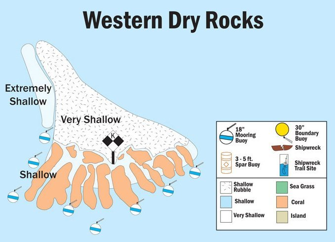
10 |
Western Dry Rocks |
Reef |
Novice - Advanced |
24°26.680 N
81°55.590 W |
120' |
|
| |
This is a very popular dive site due to it's considerable variation in
depth and marine life inhabiting the area. This site also has good spur and groove formation with more cracks, crevices, caves, ledges and cliffs than you
typically see. At the lower depths is where you'll discover the smaller caves and ledges.
The alleyways and gullies are where divers will be able to
discover remnants from ships that have wrecked in the area. In particular, the schooner Athalia, the
brigantine Stranger, and the brigantine Cimbus all foundered here
in the mid-1800's. Their remains are scattered throughout the gullies, some partially buried under coral and white sand.
A number of different species
of shark also prefer the water here. This means caution must be exercised at all times for anyone diving on this reef.
Markers - Buoys.
Details - Sharks can be present so caution is advised. Numerous cracks, crevices, sandy gullies, alleyways, and coral cliffs. Ledges and caves can be found
at lower depths and remnants from different shipwrecks are scattered in the gullies and alleyways.
Marine Life - Bull, lemon, blacktip, hammerhead and nurse sharks, barracuda, snapper, elkhorn, staghorn and other stony and gorgonian coral, grouper, spotted
eagle ray, sea turtle, yellowtail, parrotfish, blue tang, moray eels, grunts, tarpon.
Recommended Certifications - Open Water, Advanced Open Water, Enriched Air (Nitrox), Boat, Deep, Drift, Multi-Level, Peak Performance Buoyancy, Coral Reef
Conservation. |
|
|
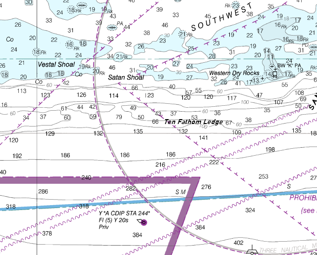
11 |
Ten Fathom Ledge |
Reef |
Novice - Advanced |
24°25.972 N
81°57.021 W |
130' |
|
| |
The overall area averages between 25 and 50 feet in depth
with a variety of interesting structures. However, at the ocean side of the reef, it rapidly drops to the ocean floor to about 130 feet. With the Gulf
stream being nearby, this not only lets you drift dive along the wall, it keeps the water clean. It also acts as a superhighway for the larger pelagic
fish migrating through the area which can add some real interest. Some of the bigger pelagic species that move through the Gulf stream are the fighting
fish everyone dreams about. Marlin, sailfish, and mahi mahi all travel this route.
The All Alone Wreck is also close by, and it sits just off the
reef at about 90' in depth. It's hull is split open and you'll find that a wide variety of fish move through the area including big grouper. With the
wreck being so close, you now have the added benefit of something else to explore.
Markers - None.
Details - At Ten Fathom ledge the current can be strong. Numerous ridges, caverns and caves to explore, plus a mini-wall (Ten Fathom Bar) dropping to
130'. The coral reef at the bar stretches approximately 4 miles.
Marine Life - Grouper, lobsters, crabs, spiny oysters, yellowtail, blue tangs, grunts, barracuda, parrotfish, spotted eagle rays, massive sea sponges,
large coral, shark, sea fans and other gorgonian coral.
Recommended Certifications - Open Water, Advanced Open Water, Enriched Air (Nitrox), Boat, Deep, Drift, Multi-Level, Peak Performance Buoyancy, Coral Reef
Conservation. |
|
|
12 |
 |
Reef |
Tech ONLY |
24°28.800 N
82°07.950 W |
600' |
|
| |
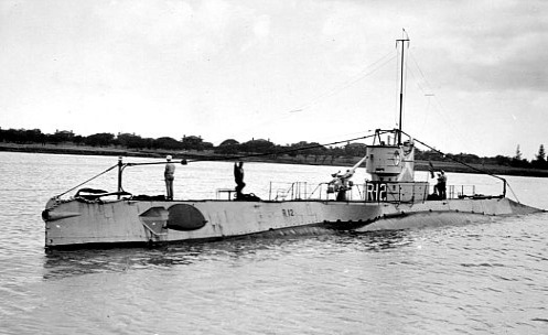
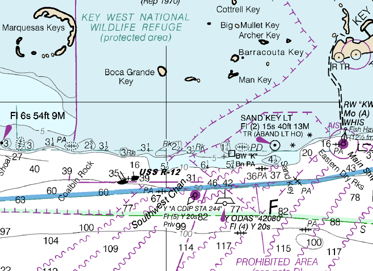
Originally launched in 1919, this 186 foot long submarine had an
18 foot beam and was developed to be a larger version of the "O" Class sub. The R-12 was outfitted with four 21 inch torpedo tubes, and one 3 inch 50 caliber deck
gun. She was also equipped with a 1,200 hp diesel engine which gave her a surface running speed of 13.5 knots, and a submerged speed of 10.5 knots.
Over
the years, she patrolled the seas performing numerous exercises until December 1932 when she was decommissioned and joined the Reserve Fleet. In 1940, during WW II,
she was reactivated and once again served her country in different capacities. In 1943 she began the final leg of her career as a training vessel for submariners
operating out of Key West.
On June 12, 1943, the R-12 was off Key West and was preparing for a torpedo practice run when her collision alarm sounded.
Reports indicate that her forward battery compartment was flooding and this information was passed to the Commanding Officer and other personnel on the bridge.
Immediately, instructions were given to blow her main ballast and close the hatches, but before anything could be done to prevent disaster, she sank in 15 seconds.
Out of the crew members on board, 42 died, including 2 Brazilian navy officers and 13 trainees. The CO, another officer and 3 enlisted men who were also
on the bridge, were the only survivors.
On May 25, 2011, her deep underwater location was discovered by Tim Taylor and his vessel, the RV Tiburon.
Using an underwater robot they've been able to successfully capture pictures of her lying on the ocean floor. The RV Tiburon is also collecting data which is being
shared with the Navy in an effort to solve the mystery of the R-12's sudden and terrible death dive.
Markers - None.
Details - Not a likely dive site due to extreme depth.
Marine Life - Minimal due to water temperatures, extreme depth, and lack of light.
Recommended Certifications - Technical diving. |
|
|
|
|
13 |
Marquesas Keys |
Reef |
Novice - Advanced |
24°28.800 N
82°07.950 W |
120' |
|
| |
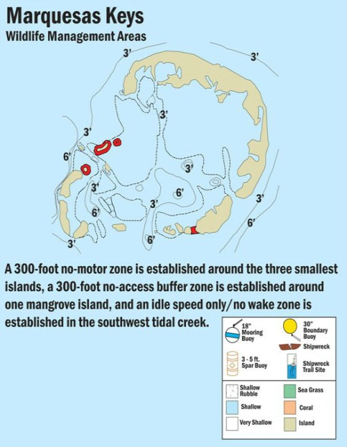
Diving Marquesas Keys is a unique experience in many ways. First of
all, it's a chain of islands spanning about 3.5 miles in width. It's comprised mainly of 10 hardwood hammock islands fringed with mangroves with a lagoon in the
center. It's also the only know atoll in North America, so if you've never been on a diving trip here, add another "first" to your list.
Over the centuries,
numerous vessels have also wrecked in the vicinity. Two of the most famous wrecks are the Atocha and the Santa Margarita, discovered by Mel Fisher in 1985.
Markers - Can buoy marks the location of the Rock.
Details - Strong currents, caves, some islands have sandy beaches, 1000' off south side there are large coral clusters, 2 famous wrecks, the Atocha and the Santa
Margarita are near here. Good kayak, photography and bird watching site if you have time.
Marine Life - Many varieties of shark, sea turtles, large coral head clusters, sting rays, snook, squirrel fish, barracuda, goliath grouper, jacks, permit,
margates, bonefish, grunt, tarpon.
Recommended Certifications - Open Water, Advanced Open Water, Enriched Air (Nitrox), Boat, Deep, Drift, Multi-Level, Peak Performance Buoyancy, Coral Reef
Conservation. |
|
|
14 |
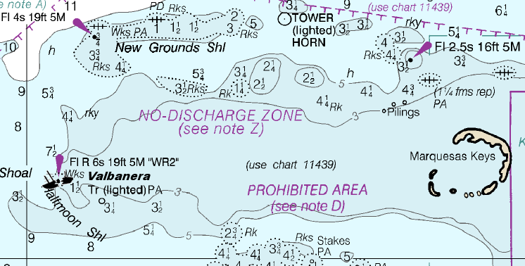
Valbanera |
Wreck |
Novice - Intermediate |
24°33.480 N
82°28.414 W |
40' |
|
| |
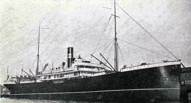
The Valbanera, a 399 foot Spanish passenger liner, is another
one of those ship disasters that plagues shipping history. Everyone knows the fate of the passengers aboard the Titanic. Well, the exact opposite is true of
those aboard this ocean liner.
In September, 1919, this ship's course was plotted for Havana, Cuba. With a hurricane brewing, some of the
passengers decided to disembark early at Santiago, Cuba. Leaving port, the ship then made way towards Havana. On September 8, she reached her destination but
the magnitude of the hurricane had risen considerably, prohibiting access to the harbor. To avoid wrecking the ship, Captain Ramon Martin Cordero decided to
ride out the hurricane. He signaled this decision to port and this was the last communication recorded from the ocean liner. Shortly thereafter, the ship was
discovered by a group of sea sponge divers who clearly saw her name plate and reported her location off Key West near Rebecca Shoals light.
The Coast Guard
sent out their cutter, the Tuscarosa, and the sub-chaser 203 to investigate. Ensign Roberts, the commander of the sub-chaser dove below, and confirmed her
identity when he saw the ship's name plate. The problem was, the ship was smaller than what they believed she should be. To make a final determination, on
September 20, Rear Admiral Decker visited the scene. His announcement confirmed the ship's fate.
The unanswered question on everyone's mind was
what had happened to the 400 passengers and 88 crew members believed to have been on board. No bodies were ever recovered at the wreck site, and no reports ever
came in of bodies or of survivors being found elsewhere. The day of Rear Admiral Decker's announcement, a dispatch was received in Madrid from Vienna, officially
confirming the loss of the ship. The dispatch also included the manifest with the names of the remaining 300 passengers plus the names and rank of the 74 crew
members on board. The number of passengers fortunately was less than what had originally been suspected.
The great mystery shrouding this ship
accident is that no bodies or human bones were recovered, and no life boats were launched. Since the life boats were still present, where did the people go? How
could they have disappeared without a trace? Even the day of the official announcement, reports came in that signals had been recently heard from a ship in distress,
in both Havana and Key West. However, the signals were too weak to make any positive identification or pinpoint their location.
Markers - None.
Details - Heavy silt build up has made this a bad diving site for finding artifacts.
Marine Life - Numerous species of tropical fish, jack, shark.
Recommended Certifications - Open Water, Advanced Open Water, Enriched Air (Nitrox), Boat, Drift, Multi-Level, Peak Performance Buoyancy, Wreck, Coral Reef
Conservation. |
|
|
|
|
|
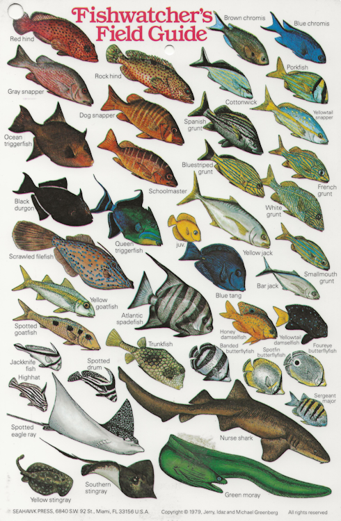
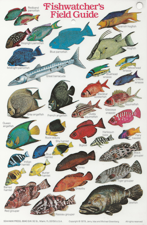
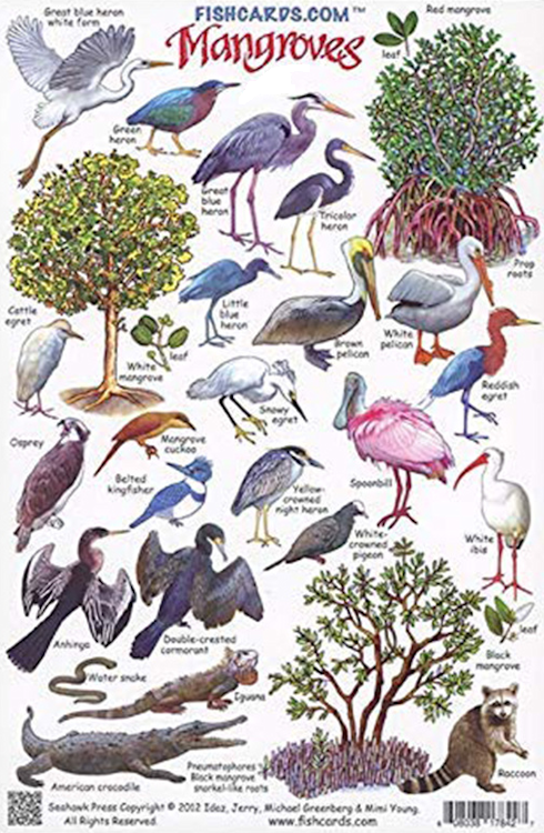
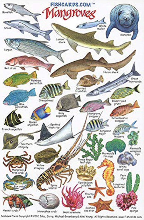
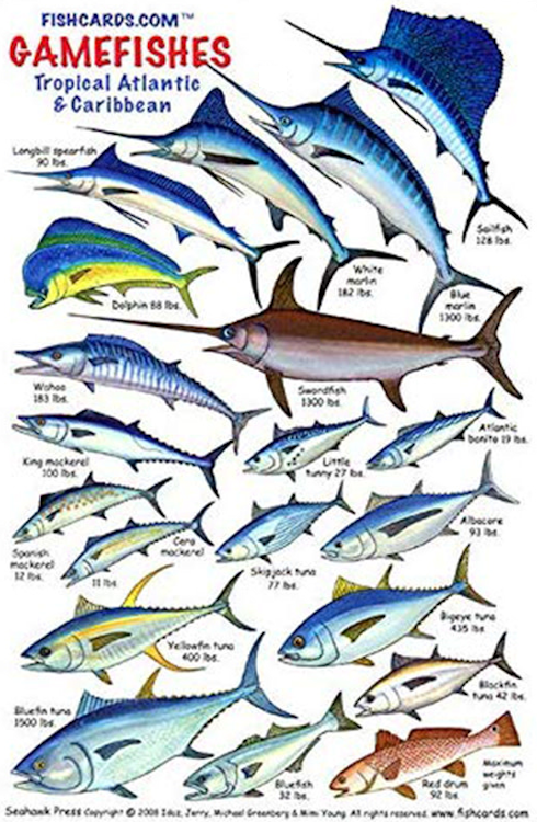
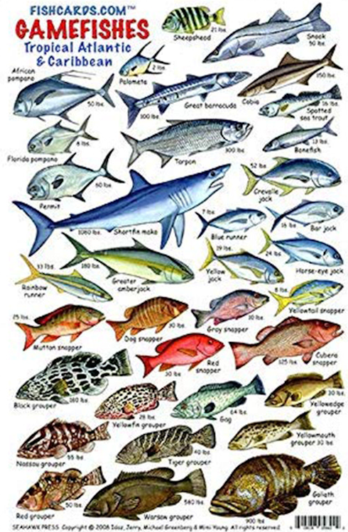
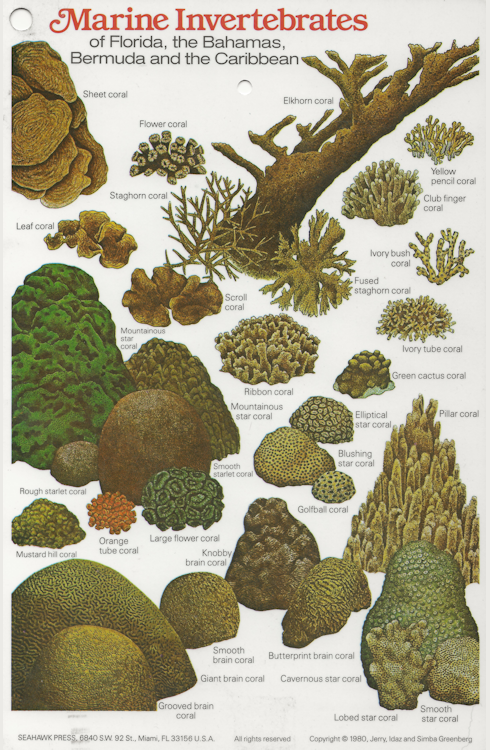
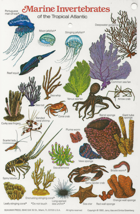
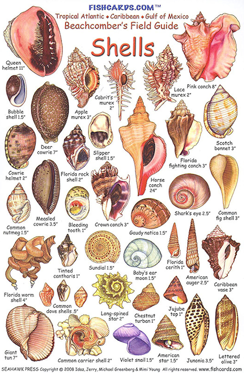
Reef and Fish Cards |
| Since there are thousands of different species of fish and coral, these ID cards will help you identify what you see under the ocean. |
|
|
|
|
|
|
|
|
|
|
|
|