|
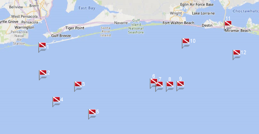
Site Name |
Dive Type |
Difficulty |
GPS |
Max Depth |
Map |
|
1 |
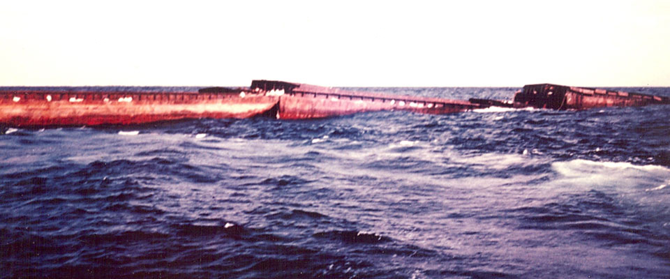
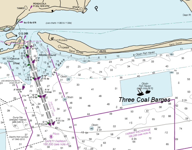
Three Coal Barges |
Wreck |
Novice - Intermediate |
30°17.450 N
87°13.257 W |
50' |
|
| |
In 1974, while en route to their designated offshore reef site, the Three Coal Barges broke free from
their transport. In an emergency operation, US Navy demolition experts boarded the runaway barges and detonated explosive charges, sinking them in their present
location before they were driven ashore by rough seas.
Today the barges lie end to end amidst a field of bridge rubble, creating a rich undersea
habitat for divers to visit and enjoy. This is also a great training site for newer divers.
This site is part of the Florida Panhandle Shipwreck
Trail.
Markers - None.
Details - The barges are 140' long with a 40' beam. Not much of the barges remain except for the beams and cross members. Depending upon the time of year,
visibility can range from 25' to 50'.
Marine Life - Goliath grouper, barracuda, and the occasional loggerhead.
Recommended Certifications - Open Water, Advanced Open Water, Enriched Air (Nitrox), Boat, Drift, Multi-Level, Peak Performance Buoyancy, Wreck, Coral
Reef Conservation. |
|
|
|
|
2 |
San Pablo |
Wreck |
Intermediate - Advanced |
30°11.333 N
87°13.057 W |
80' |
|
| |
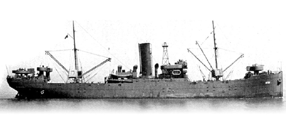
Launched from Belfast, Ireland, in 1915, San Pablo started her life
as a fruit transport running bananas from Central America to the United States. Early during World War II while in Costa Rica, she was sunk by a German U-boat killing
24 of her crew. After an attempt to refloat her failed in 1943, she was purchased by the US for weapons testing.
In August of 1944, the Navy had a top
secret experiment called Project Campbell. It was an radio controlled unmanned boat carrying 3,000 pounds of explosives guided by a an old TV camera. When the San Pablo
was hit, onlookers from shore saw the explosion. Rampant rumors of foreign spies and espionage, San Pablo was soon given her local name Russian Freighter.
This site is part of the Florida Panhandle Shipwreck Trail.
Markers - None.
Details - Wreckage is scattered across the seafloor. The most intact portion is the stern, boilers, and refrigeration coils. The rest of the vessel is scattered
around in the site and consists of twisted metal.
Marine Life - Lots of different corals, goliath grouper, barracuda, and the occasional loggerhead.
Recommended Certifications - Open Water, Advanced Open Water, Enriched Air (Nitrox), Boat, Drift, Multi-Level, Peak Performance Buoyancy, Wreck, Coral Reef
Conservation. |
|
|
|
|
3 |
Pete Tide II |
Wreck |
Intermediate - Advanced |
30°8.767 N
87°4.017 W |
100' |
|
| |
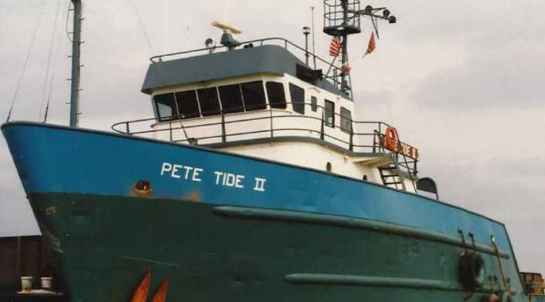
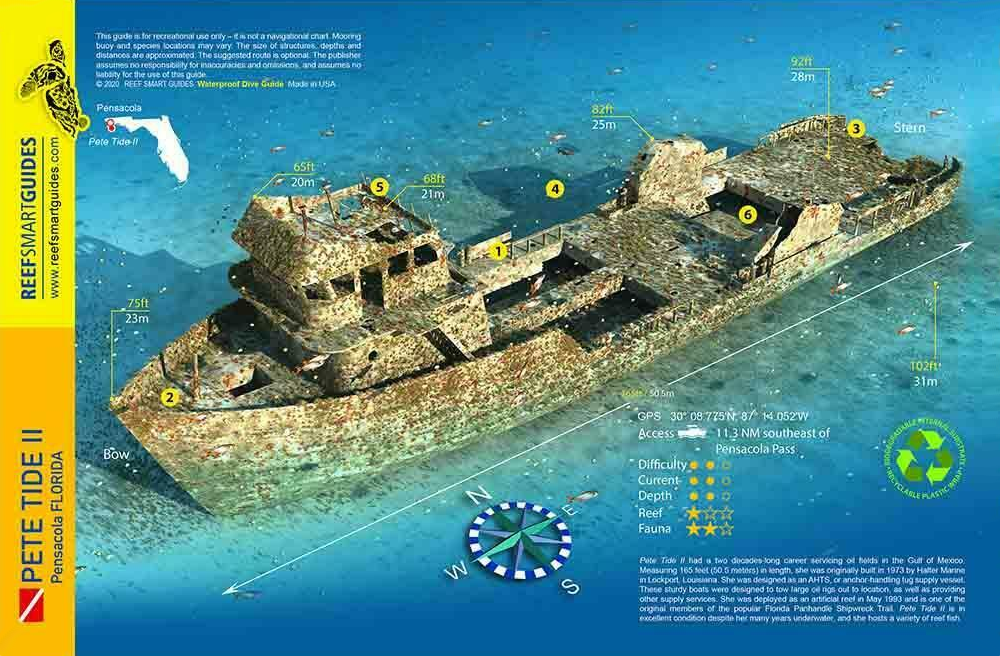
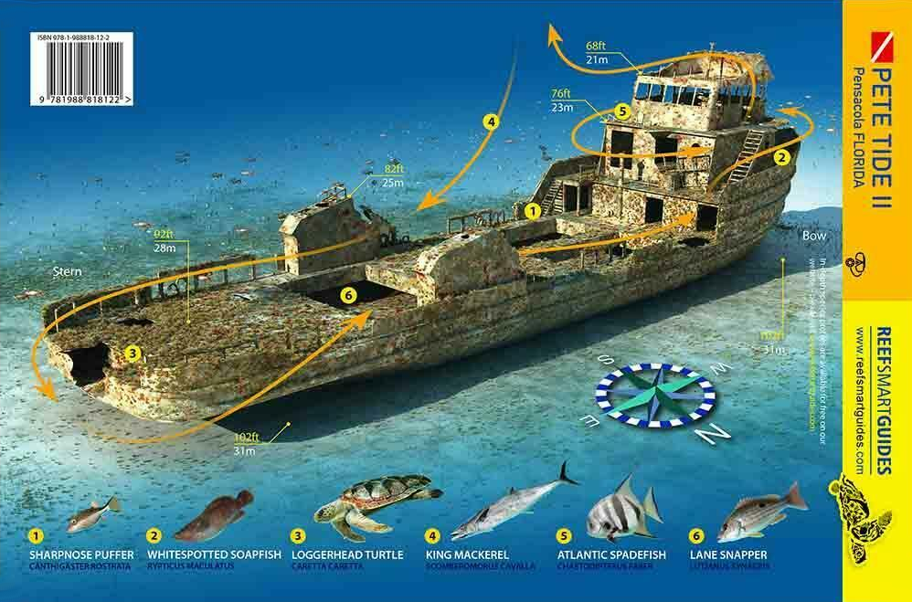
After servicing the Gulf for years supplying workers and materials to offshore oil rigs, Pete Tide II became
an artificial reef in 1993. Sitting upright in about 100 feet of water, Pete Tide II offers divers three decks of superstructure to explore starting at around 60
feet.
Pete Tide II was built in Louisiana in 1973. She was designed to be an Anchor Handling Tug Supply vessel. Her job was to tow large oil rigs to
their destination as well as provide other services.
This site is part of the Florida Panhandle Shipwreck Trail.
Markers - None.
Details - Sits upright with plenty of swim throughs. She is 165' long and the pilothouse in intact. The aft work platform is another great
place to explore.
Marine Life - Spadefish, minnows, wahoo, blackfin tuna, turtles, snapper.
Recommended Certifications - Open Water, Advanced Open Water, Enriched Air (Nitrox), Boat, Deep, Drift, Multi-Level, Peak Performance Buoyancy, Wreck, Coral
Reef Conservation. |
|
|
|
|
|
4 |
 |
Wreck |
Intermediate - Advanced |
30° 5.330 N
87° 9.640 W |
90' |
|
| |
In 1974, while en route to their designated offshore reef site, the Three Coal Barges broke free from
their transport. In an emergency operation, US Navy demolition experts boarded the runaway barges and detonated explosive charges, sinking them in their present
location before they were driven ashore by rough seas.
Today the barges lie end to end amidst a field of bridge rubble, creating a rich undersea
habitat for divers to visit and enjoy. This is also a great training site for newer divers.
This site is part of the Florida Panhandle Shipwreck
Trail.
Markers - None.
Details - The barges are 140' long with a 40' beam. Not much of the barges remain except for the beams and cross members. Depending upon the time of year,
visibility can range from 25' to 50'.
Marine Life - Goliath grouper, barracuda, and the occasional loggerhead.
Recommended Certifications - Open Water, Advanced Open Water, Enriched Air (Nitrox), Boat, Drift, Multi-Level, Peak Performance Buoyancy, Wreck, Coral
Reef Conservation. |
|
|
|
|
|
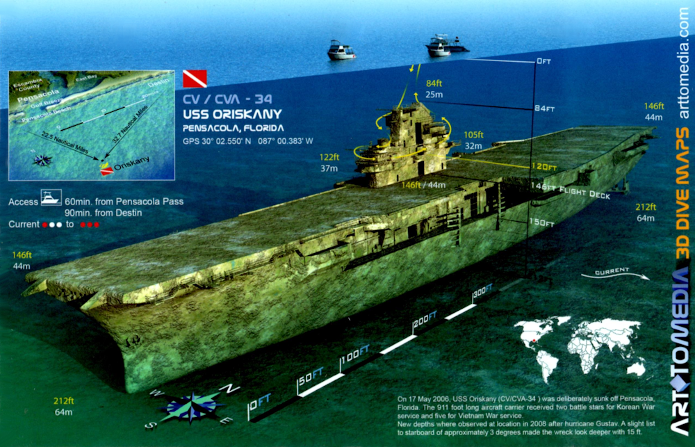
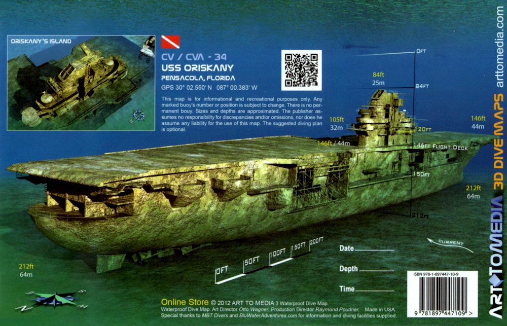
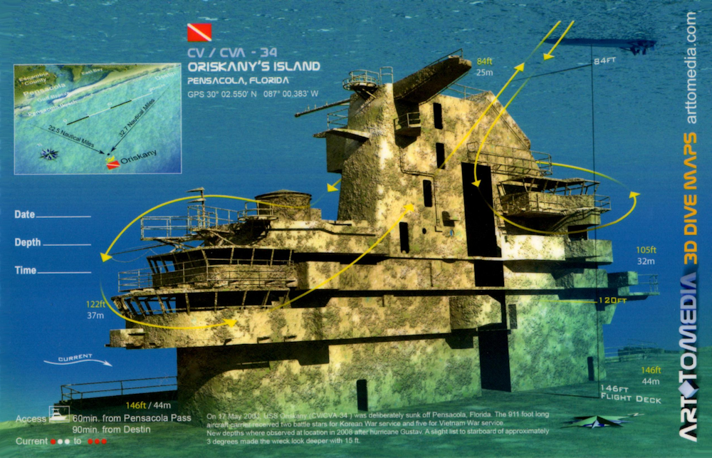
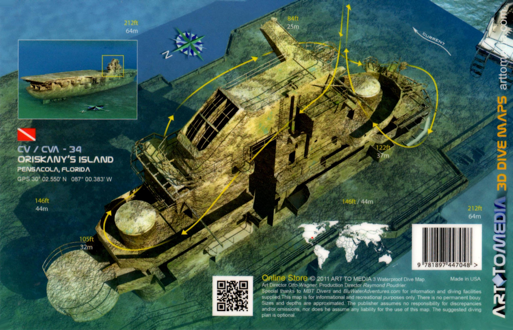
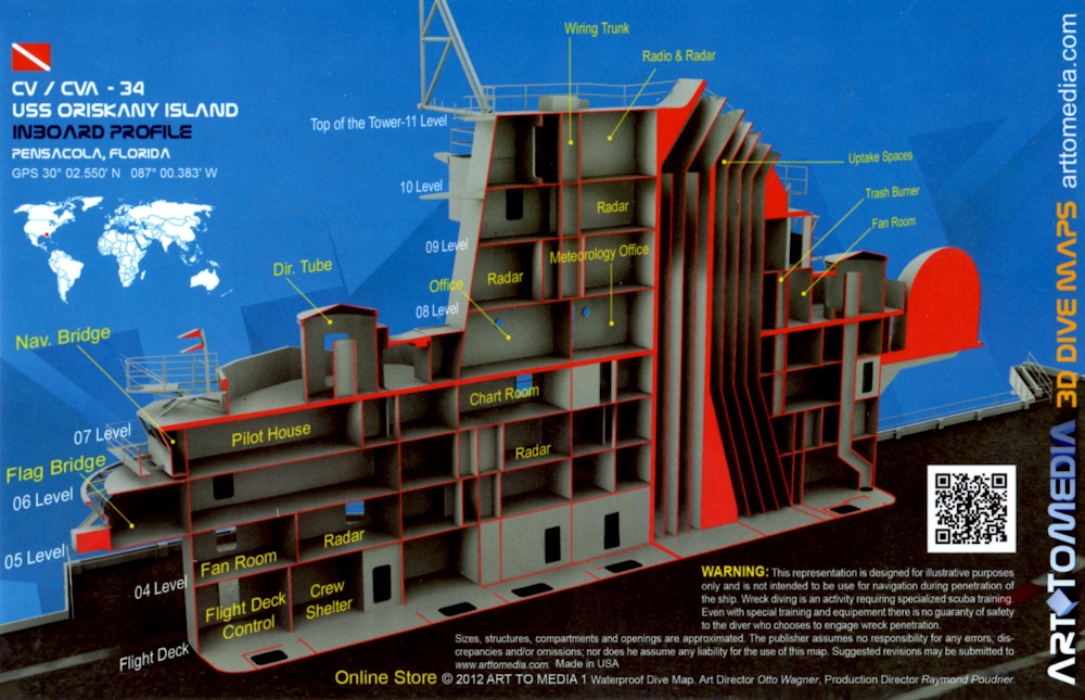
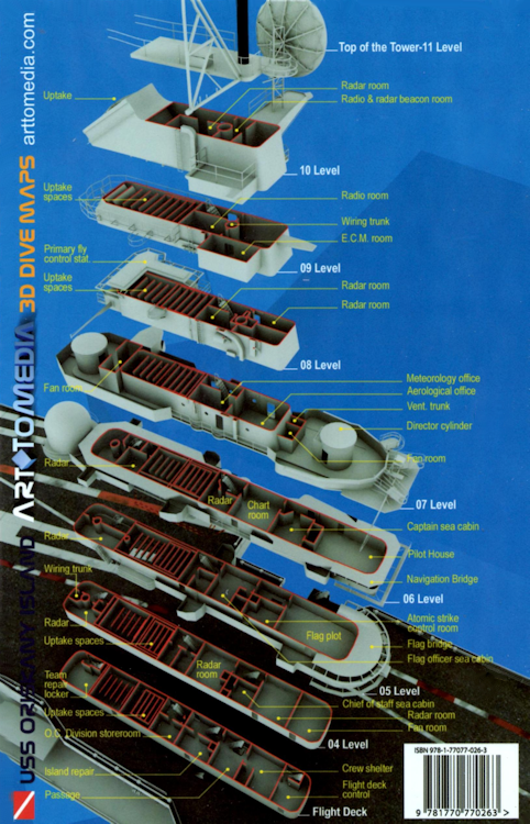
5 |
 |
Wreck |
Advanced - Tech |
30°2.555 N
87°0.397 W |
212' |
|
| |
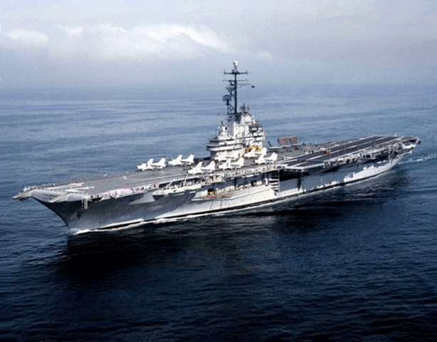
The USS Oriskany, affectionately referred to as The Mighty O, was a US Navy Essex-class aircraft
carrier named for a village in central New York state, scene of one of the bloodiest battles of the Revolutionary War on August 6, 1777. She was ordered in 1942 and
her keel was laid on May 1, 1944 and launched on October 13, 1945. After 85% complete, her construction was suspended in 1946 and reordered a year later, torn down
to 60% and rebuilt with a new modified design. First commissioned on September 25, 1950, she was sent to Jacksonville for qualifications.
In 1952, the
Mighty O went back to the yards in San Francisco and was redesignated as an Attack Aircraft Carrier with the designation of CVA-34. On her first deployment, at sunrise,
Sunday, June 29, 1952, after twenty-four hours of bucking some of the worst swells and gales the South Atlantic could offer, the Oriskany became the first aircraft
carrier in history to go around Cape Horn on her way to Korea. She arrived in Japan in mid October and then served off the Korean coast from October 31 and departed
April 22, 1953, arriving in San Diego on May 2. After some more training, she went back to Korea in October serving in the Sea of Japan and around the Philippines,
she went back to San Francisco for an overhaul. In October, 1954, she participated in the Korean War era movie, The Bridges at Toko-Ri and then went back to Korea
for a 3rd time.
In 1956, she was modernized at the San Francisco yards. She received a new angled flight deck, aft deck edge elevator, enlarged forward
elevator, and an enclosed hurricane bow. Powerful new steam catapults replaced the older hydraulic catapults. The wooden flight deck planking was also replaced with
aluminum planking.
Oriskany left for Vietnam in April 1965 and returned to San Diego in December. She left once again in May 1966 returning to Dixie
Station off South Vietnam in June and then shifting to Yankee Station in the Gulf of Tonkin in July. The carrier was on station the morning of October 26, 1966, when
a fire erupted on the starboard side of the ship's forward hangar bay and raced through five decks, killing 44 men. Many who lost their lives were veteran combat
pilots who had flown raids over Vietnam a few hours earlier. A seaman accidentally ignited a magnesium parachute flare, and in a panic, threw it into a weapons locker
where the flares were kept for storage. Instead of throwing it over the side into the water, this ignited all the flares in the locker and caused the horrific damage.
A week later, Oriskany sailed home to San Diego.
After repairs, Oriskany was sent back to Yankee Station in July, 1967. On October 26, 1967,
then-Lieutenant Commander John McCain flew off Oriskany in an A-4 Skyhawk on his 23rd bombing mission of the Vietnam War. He was shot down that day and was a prisoner
of war until January 1973. The carrier returned home in January 1968 having completed 122 days of combat operations where she lost half of her assigned planes, 20
pilots killed, and another 9 taken prisoner after having flown over 9,500 missions, including 181 air strikes.
After eight months at home, Oriskany
went back to Vietnam for her fourth tour. She served a fifth tour in 1970, a sixth in 1971 and seventh in 1972. The 1972 deployment was met with various problems,
including a collision with ammunition ship USS Nitro during an underway replenishment and caused the loss of two propellers and one shaft. Oriskany finally sailed
for home, arriving at Alameda on March 30, 1973, after completing 169 days on the line, her longest and what proved to be her last combat tour. All-in-all she
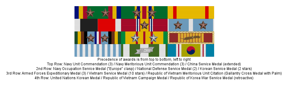
received ten battle stars for her Vietnamese service.
Oriskany was decommissioned on September 30, 1976, and laid up for long-term storage in
Bremerton, WA. She was sold for scrap a couple of times but due to lack of funding, she was repossessed by the Navy. The Navy announced on April 5, 2004, that it
would transfer the former aircraft carrier to the State of Florida for use as an artificial reef. On May 17, 2006, is took 37 minutes for the Oriskany to sink. She
sat upright with her flight deck at 135 feet. After Hurricane Gustav in 2008, she settled 10 more feet leaving the flight deck at 145 feet. It is now popularly
known as the Great Carrier Reef as she is the largest artificial reef in the world.
This site is part of the Florida Panhandle Shipwreck Trail.
Markers - None.
Details - Sits upright in a north-south orientation but due to storms and hurricanes, she is starting to list a little. Her superstructure is about 84' and
the flight deck is about 146'. The bottom sits at 215'.
Marine Life - Whale sharks frequent this site as well as other large pelagic species.
Recommended Certifications - Open Water, Advanced Open Water, Enriched Air (Nitrox), Boat, Deep, Drift, Multi-Level, Peak Performance Buoyancy, Wreck, Coral
Reef Conservation, Technical diving for going down to the flight deck or lower. |
|
|
|
|
|
|
|
|
|
|
|
6 |
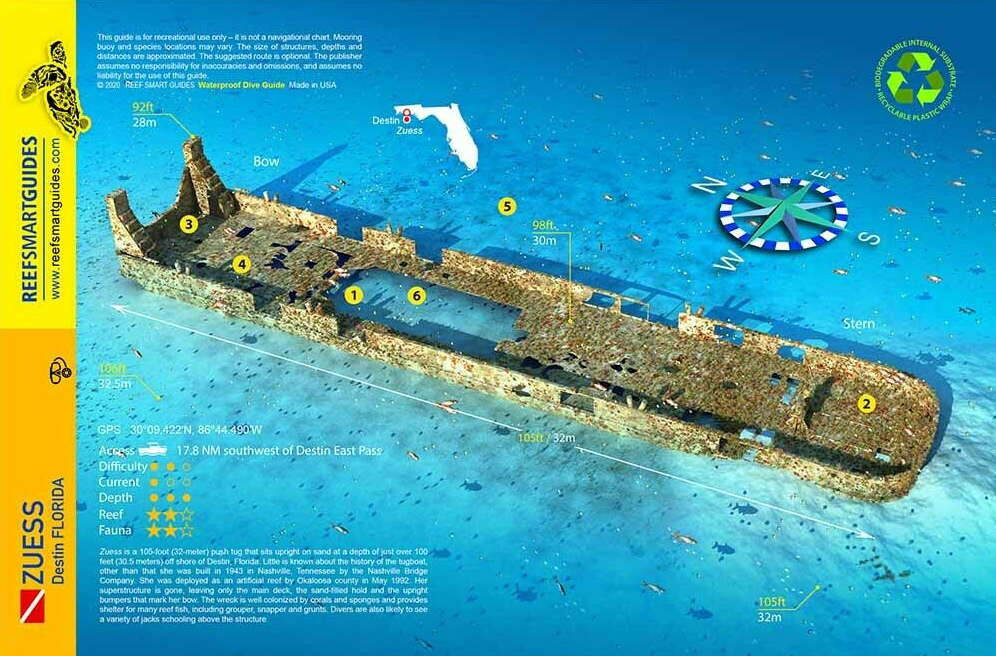
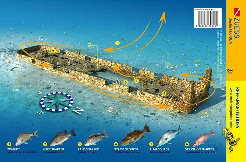
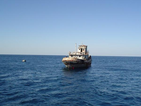
Zuess |
Wreck |
Advanced |
30°9.422 N
86°44.490 W |
107 |
|
| |
Tugboat Zuess was a steel hulled vessel sunk by Okaloosa County as an artificial reef on June 29th, 1992.
Built in 1943 by the Nashville Bridge Company, little else is known about this tug.
This site is part of the Florida Panhandle Shipwreck Trail.
Markers - None.
Details - Superstructure is gone leaving only the main deck, the sand filled hold, and the upright bumpers that mark the bow.
Marine Life - Grouper, snapper, grunts, jacks.
Recommended Certifications - Open Water, Advanced Open Water, Enriched Air (Nitrox), Boat, Deep, Drift, Multi-Level, Peak Performance Buoyancy, Wreck, Coral
Reef Conservation. |
|
|
|
7 |
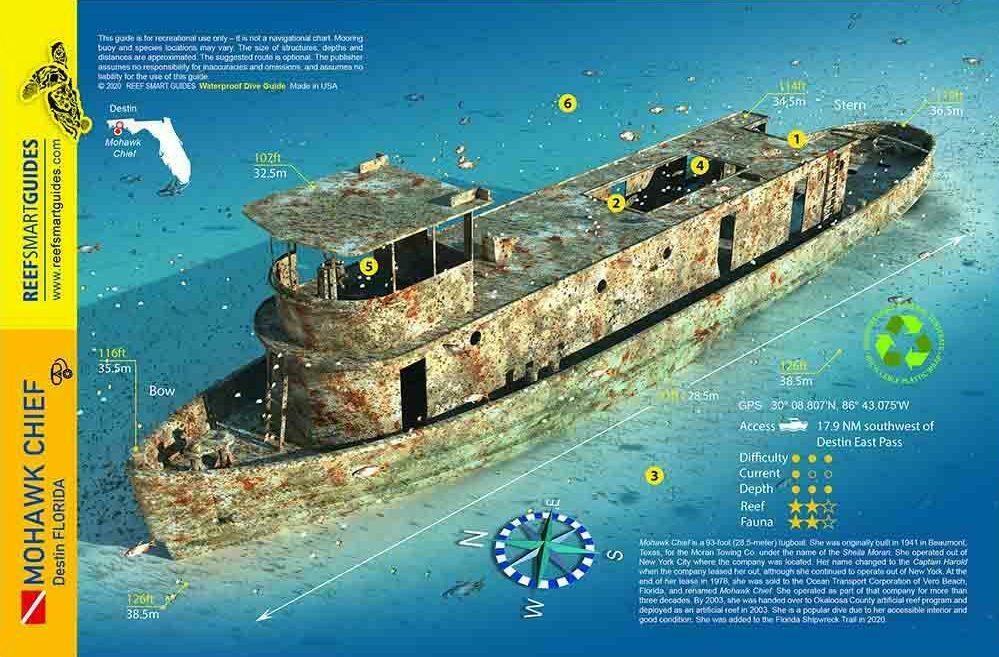
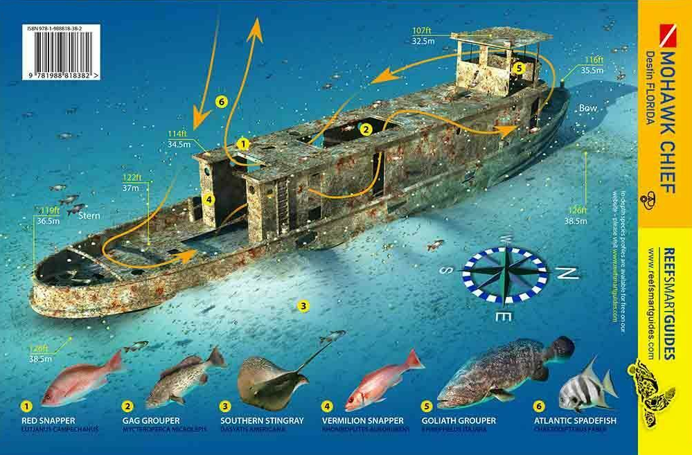
Mohawk Chief |
Wreck |
Advanced |
30°8.807 N
86°43.075 W |
125' |
|
| |
Built in 1941, by the Bethlehem Steel Company of Beaumont, Texas as the
Sheila Moran with the hull number 246 for the Moran Towing Company of New York, New York. The tug was later leased, as the Capt. Harold. In 1978, the tug was retuned
to the Moran Towing Company and she was renamed the Sheila Moran. In 1978, she was acquired by the Ocean Transport Corporation of Vero Beach, Florida and renamed as
the Mohawk Chief.
She was sunk as an artificial reef on June 23rd, 2003 and sits upright on the seafloor at the center of Sand Dollar Complex #7, which
consists of six concrete artificial reef structures about 800 feet away from each other in a hexagonal shape.
This site is part of the Florida Panhandle
Shipwreck Trail.
Markers - None.
Details - Swim throughs are possible in the pilot house, and divers can peep through various port holes.
Marine Life - Baitfish, amber jack, a Goliath Grouper, sand dollars scattered around the seafloor.
Recommended Certifications - Open Water, Advanced Open Water, Enriched Air (Nitrox), Boat, Deep, Drift, Multi-Level, Peak Performance Buoyancy, Wreck, Coral
Reef Conservation. |
|
|
|
8 |
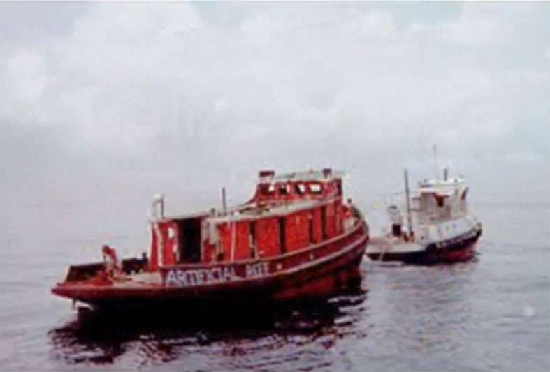
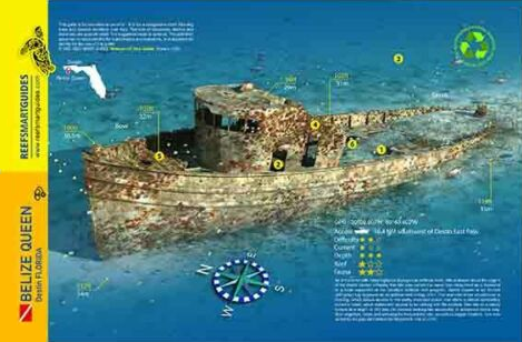
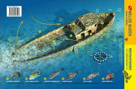
Belize Queen |
Wreck |
Advanced |
30°8.802 N
86°40.376 W |
112' |
|
| |
The Belize Queen, commonly known as Bob Reay Reef, is a steel hulled 85 foot long tugboat sunk as an
artificial reef on May 30th, 2001. This 110-ton vessel has an intact pilot house and bridge that visitors can explore.
This site is part of
the Florida Panhandle Shipwreck Trail.
Markers - None.
Details - Vessel sits upright with swim throughs in the pilot house and bridge.
Marine Life - Swarms of baitfish and reef fish and even a few jellyfish.
Recommended Certifications - Open Water, Advanced Open Water, Enriched Air (Nitrox), Boat, Deep, Drift, Multi-Level, Peak Performance Buoyancy, Wreck, Coral
Reef Conservation. |
|
|
|
|
|
9 |
Chepanoc |
Wreck |
Advanced |
30°8.833 N
86°37.612 W |
107' |
|
| |
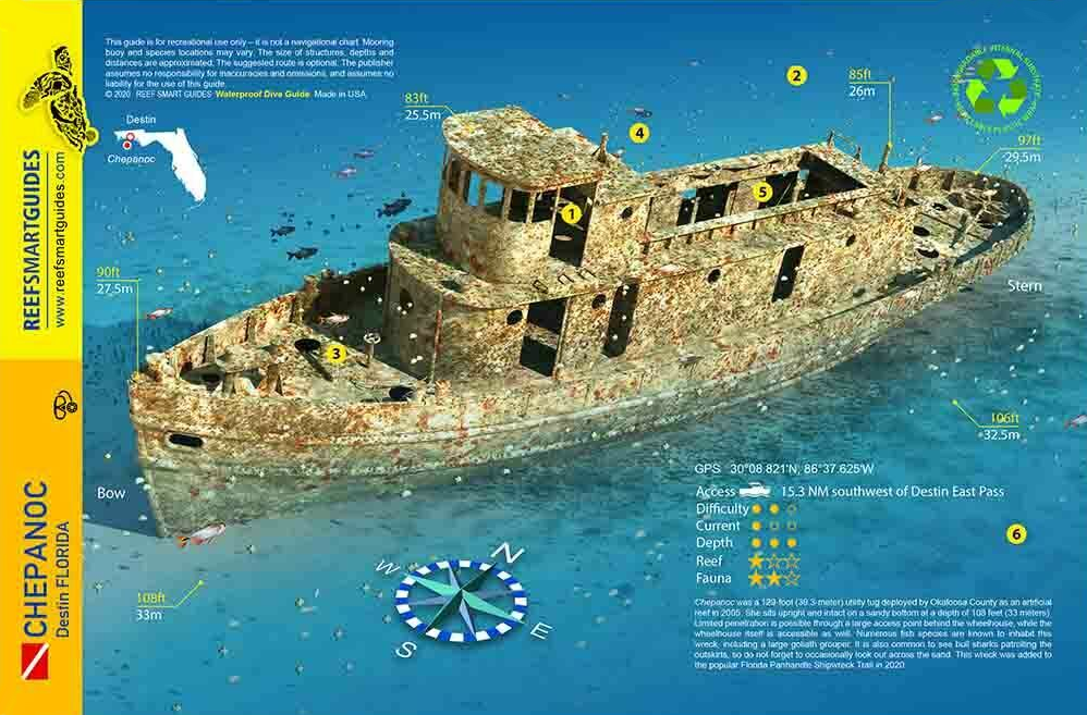
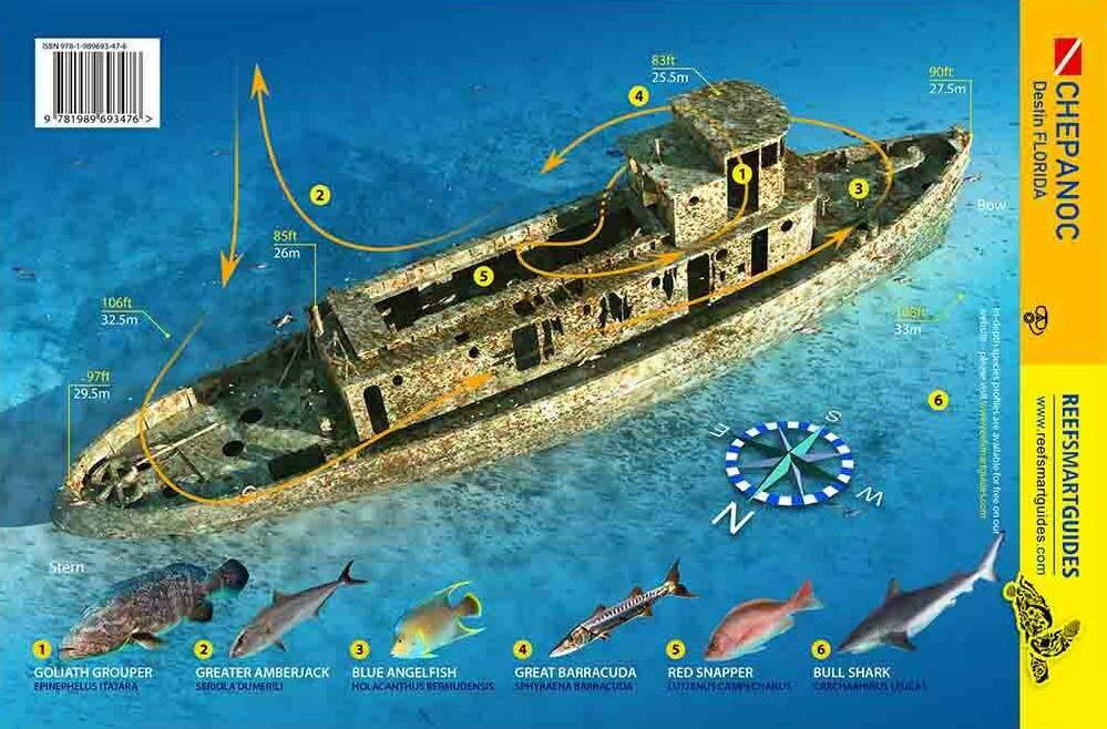
Chepanoc was a steel-hulled, 129 foot long tugboat sunk as an artificial reef by Okaloosa County on
December 1st, 2005. She sits in the center of the Starfish Reef Complex.
This site is part of the Florida Panhandle Shipwreck Trail.
Markers - None.
Details - Sits upright with swim throughs in the pilot house.
Marine Life - French angelfish, barracuda, sea urchins, and other reef fish.
Recommended Certifications - Open Water, Advanced Open Water, Enriched Air (Nitrox), Boat, Deep, Drift, Multi-Level, Peak Performance Buoyancy, Wreck, Coral
Reef Conservation.
|
|
|
|
|
|
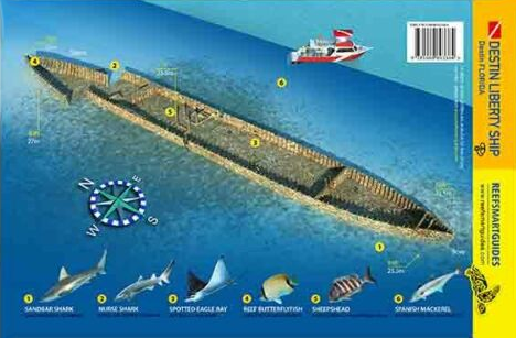
10 |
Thomas Hayward |
Wreck |
Intermediate - Advanced |
30°18.376 N
86°36.222 W |
90' |
|
| |
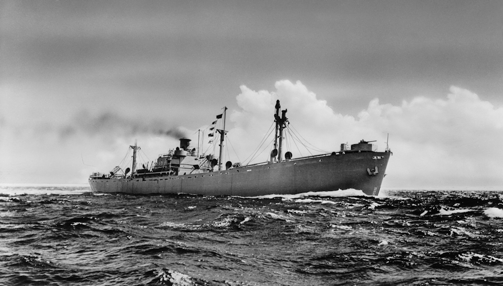
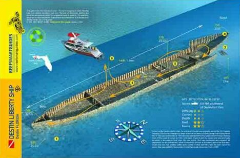
Thomas Hayward, known as the Destin Liberty Ship, was a 360 foot long
steel Liberty Ship built by the Alabama Drydock Company in Mobile, Alabama in 1942. It was named for Thomas Heyward, Jr., a signer of the United States Declaration
of Independence and of the Articles of Confederation as a representative of South Carolina.
Liberty ships were a class of United States cargo ship that were cheaply
mass-produced during World War II. This vessel served during the war by transporting allied troops from the United States to Europe. After its WWII and Korean War
service, it was purchased by the Florida Department of Natural Resources and prepped for designation as an artificial reef. It was sunk south of Okaloosa Island
pier on April 14th, 1977.
This site is part of the Florida Panhandle Shipwreck Trail.
Markers - None.
Details - Sits upright with plenty of spaces to explore. She has an overall length of 441' and a beam of 57'.
Marine Life - Goliath grouper, barracuda, and the occasional loggerhead.
Recommended Certifications - Open Water, Advanced Open Water, Enriched Air (Nitrox), Boat, Drift, Multi-Level, Peak Performance Buoyancy, Wreck, Coral Reef
Conservation. |
|
|
|
|
|
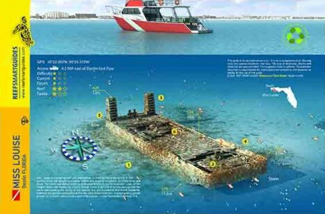
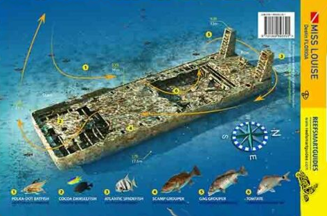
11 |
Miss Louise |
Wreck |
Novice - Intermediate |
30°22.282 N
86°25.315 W |
60' |
|
| |
Miss Louise was a push tug built in 1971 by Houma Shipbuilding Co., Houma, LA. Renamed Shell Fueler in 1973,
she is 60 feet long with a 20 foot beam. Storms have flattened some of the upper works, but there is still plenty of structure left for
divers to explore. She was sunk as an artificial reef in 1997.
This site is part of the Florida Panhandle Shipwreck Trail.
Markers - None.
Details - Sits upright on a sandy bottom.
Marine Life - Spanish mackerel, kings, barracuda, baitfish, pelagic fish, a resident goliath grouper, whale shark.
Recommended Certifications - Open Water, Advanced Open Water, Enriched Air (Nitrox), Boat, Drift, Multi-Level, Peak Performance Buoyancy, Wreck, Coral
Reef Conservation.
|
|
|
|
|
|
12 |
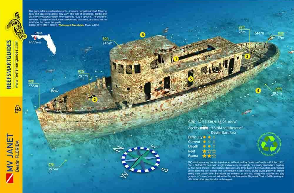
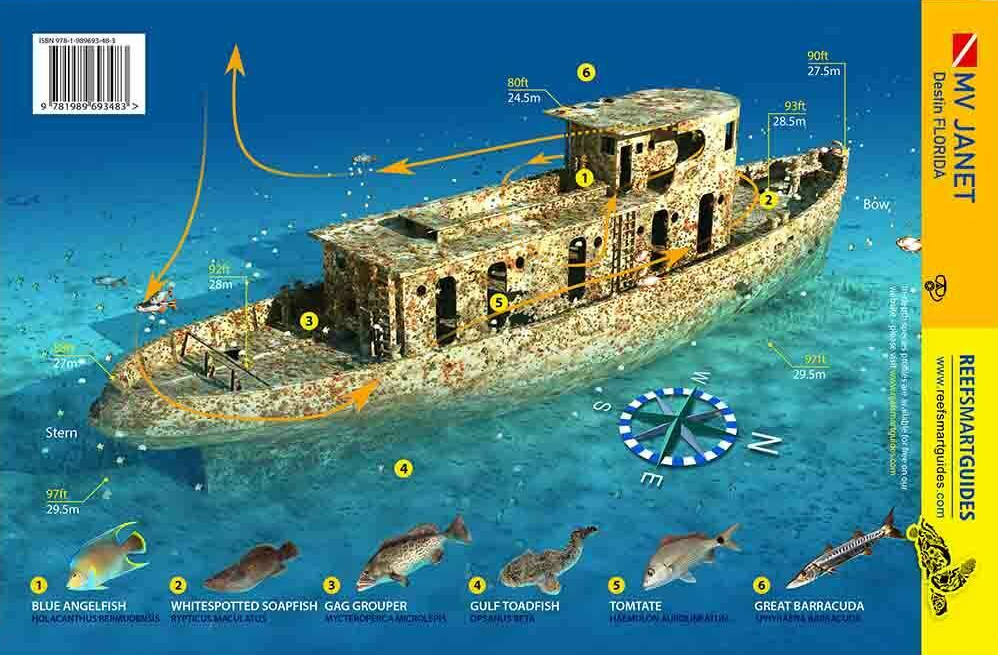
M/V Janet |
Wreck |
Intermediate - Advanced |
30°15.840 N
86°23.105 W |
93' |
|
| |
M/V Janet, an 85-foot steel tugboat, was sunk by the City of Destin on October 1st, 1997. Divers reported the
wreck was covered with baitfish and kingfish in one day. This tug is also associated with a concrete artificial reef complex, Okaloosa Haven #6.
This
site is part of the Florida Panhandle Shipwreck Trail.
Markers - None.
Details - Ship sits upright at 93 feet with 30 feet of relief. Swim throughs are possible on this vessel.
Marine Life - Snapper, trigger fish, grouper, amberjack, and a resident Goliath Grouper.
Recommended Certifications - Open Water, Advanced Open Water, Enriched Air (Nitrox), Boat, Drift, Multi-Level, Peak Performance Buoyancy, Wreck, Coral Reef
Conservation. |
|
|
|
|
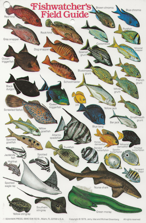
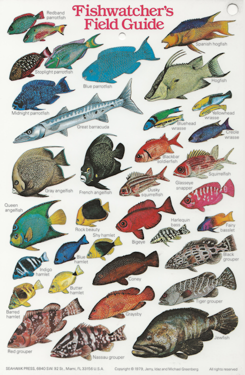
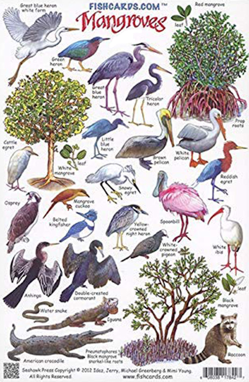
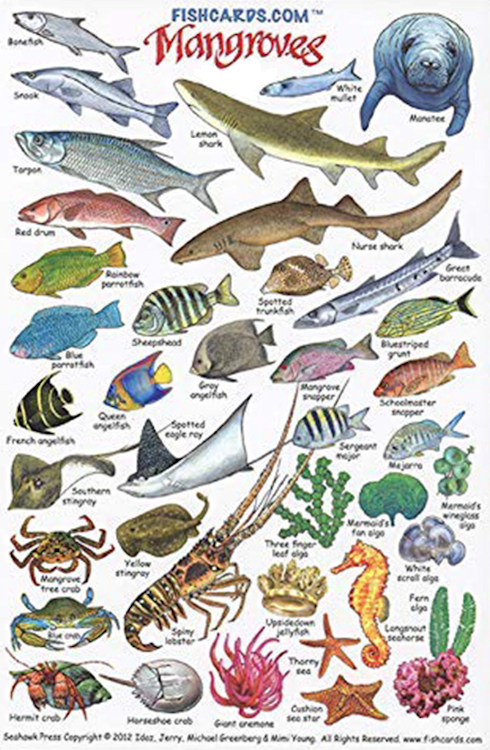
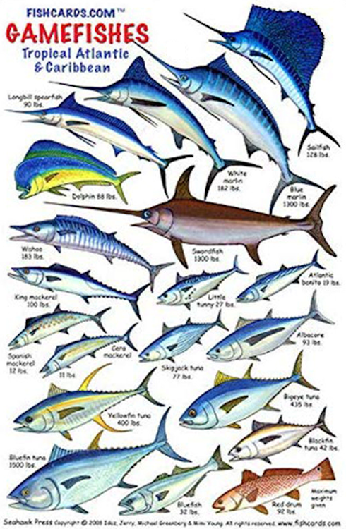
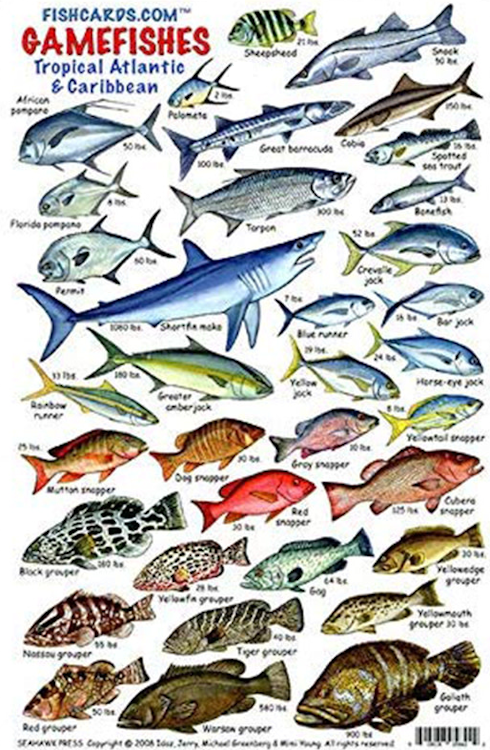
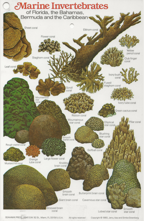
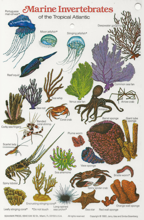
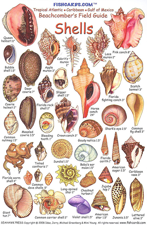
Reef and Fish Cards |
| Since there are thousands of different species of fish and coral, these ID cards will help you identify what you see under the ocean. |
|
|
|
|
|
|
|
|
|
|
|
|