|
Site Name |
Dive Type |
Difficulty |
GPS |
Max Depth |
Map |
|
1 |
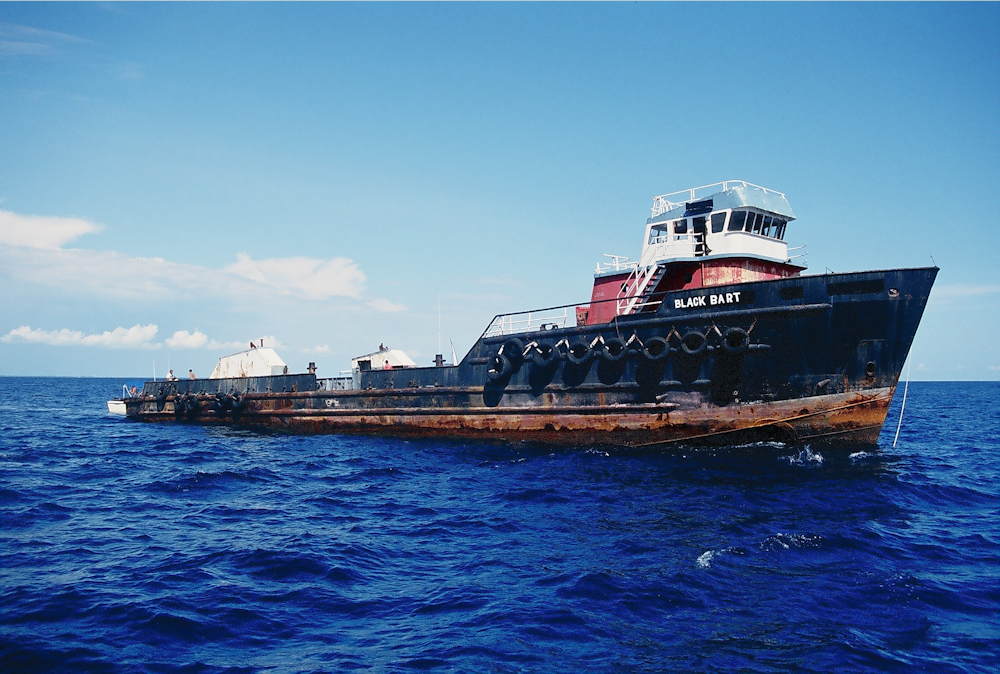
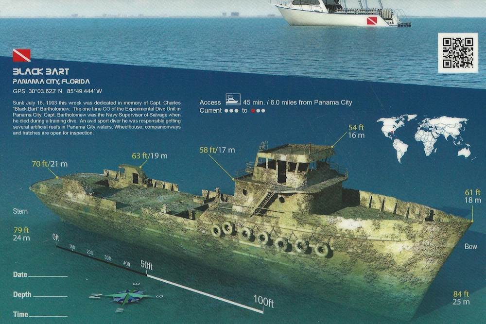
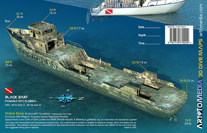
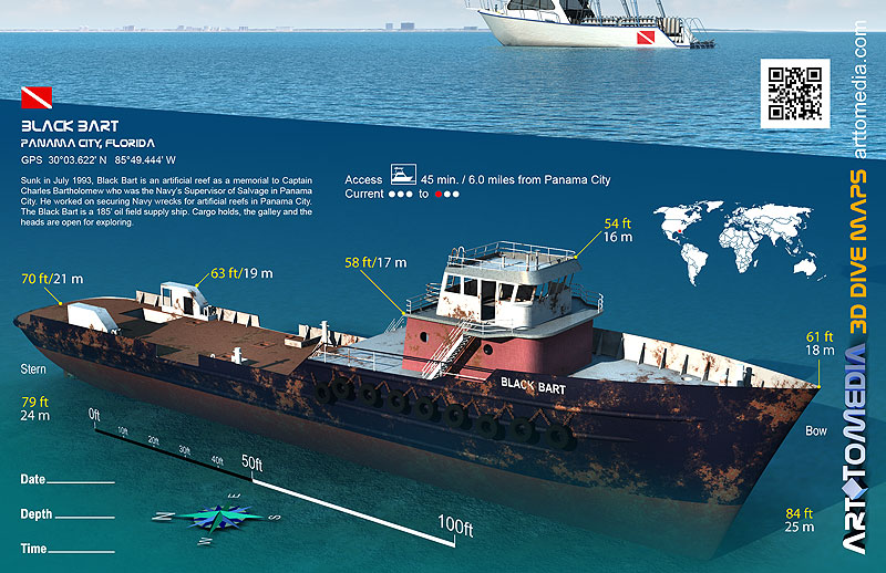
Black Bart |
Wreck |
Intermediate - Advanced |
30°3.610 N
85°49.450 W |
85' |
|
| |
Christened Vulcano del Golfo in 1977, this offshore oilfield supply
vessel was sunk as an artificial reef in 1993. She was named in memory of Captain Charles "Black Bart" Bartholomew, Commanding Officer, Navy Experimental Diving
Unit, and Navy Supervisor of Salvage who was also an avid diver in the Panama City area. Besides her oilfield job, the Vulcano del Golfo was used for offshore
diving operations.
In July of 1993, with the assistance of a grant from the Florida Department of Environmental Protection, the Bay County Reef
Program acquired this 175 foot former oil field boat. The hull was cleaned, brought to Panama City and renamed Black Bart. On July 16, 1993, Black Bart officially
became the closest and largest of the Panama City artificial reefs.
This site is part of the Florida Panhandle Shipwreck Trail.
Markers - None.
Details - The wheelhouse is at 58 feet and is a good swim through. The deck is at
65 feet the open cargo holds are at 80 feet. The ship's head and the galley,
which still has several appliances, is also accessible. The engine compartments are empty.
Marine Life - Grouper, barracuda, and other fish.
Recommended Certifications - Open Water, Advanced Open Water, Enriched Air (Nitrox), Boat, Drift, Multi-Level, Peak Performance Buoyancy, Wreck, Coral Reef
Conservation.
|
|
|
|
|
|
|
|
2 |
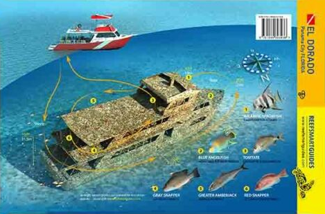
El Dorado |
Wreck |
Advanced |
29°58.916 N
85°50.950 W |
103' |
|
| |
El Dorado was deployed as an artificial reef in 2019. This 157 foot
modern luxury cruise liner originally washed ashore in Panama City during Hurricane Ivan in 2004. Marine salvor Lee Ingram, a Panama City native, purchased it and
intended to restore the vessel and place it in service. However, another hurricane, Michael in October of 2018, carried it from its dock and deposited it on its side
near the Florida State University Panama City property.
Mr. Ingram donated the vessel as an artificial reef. It was sunk 12 nautical miles south of
St. Andrew Bay Pass on May 3rd, 2019 in 103 feet of water.
This site is part of the Florida Panhandle Shipwreck Trail.
Markers - None.
Details - Vessel is 157' long.
Marine Life - Grouper, barracuda, red snapper, amberjack, and other fish.
Recommended Certifications - Open Water, Advanced Open Water, Enriched Air (Nitrox), Boat, Deep, Drift, Multi-Level, Peak Performance Buoyancy, Wreck, Coral
Reef Conservation. |
|
|
|
|
|
3 |
 |
Wreck |
Intermediate - Advanced |
29°58.475 N
85°51.915 W |
100' |
|
| |
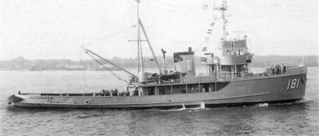
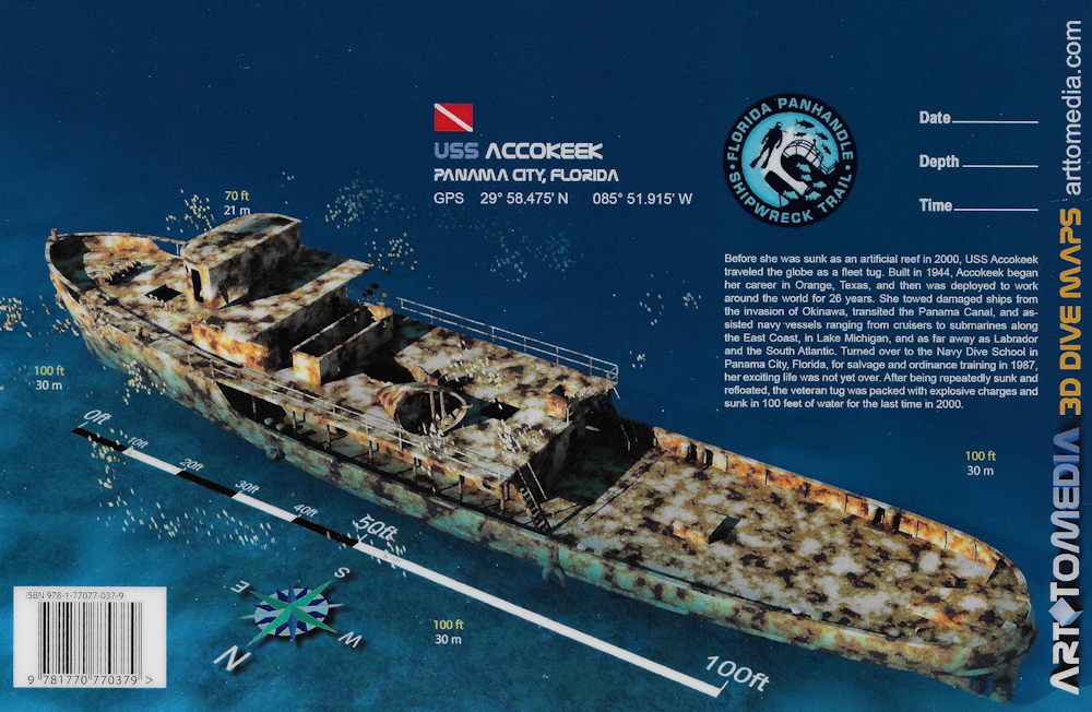
Before she was sunk as an artificial reef in 2000, USS Accokeek
traveled the globe as a fleet tug. Built in 1944, Accokeek began her career in Orange, Texas, and then was deployed to work around the world for 26 years. She
towed damaged ships from the invasion of Okinawa, transited the Panama Canal, and assisted navy vessels ranging from cruisers to submarines along the East Coast,
in Lake Michigan, and as far away as Labrador and the South Atlantic.
Turned over to the Navy Dive School in Panama City, Florida, for salvage and
ordinance training in 1987, her exciting life was not yet over. After being repeatedly sunk and refloated, the veteran tug was packed with explosive charges and
sunk in 100 feet of water for the last time in 2000.
This site is part of the Florida Panhandle Shipwreck Trail.
Markers - None.
Details - This tug has a length of 143' and 34' beam.
Marine Life - Grouper, barracuda, and other fish.
Recommended Certifications - Open Water, Advanced Open Water, Enriched Air (Nitrox), Boat, Deep, Drift, Multi-Level, Peak Performance Buoyancy, Wreck, Coral
Reef Conservation. |
|
|
|
|
|
4 |
FAMI Tugs |
Wreck |
Intermediate - Advanced |
29°58.132 N
85°51.259 W |
100' |
|
| |
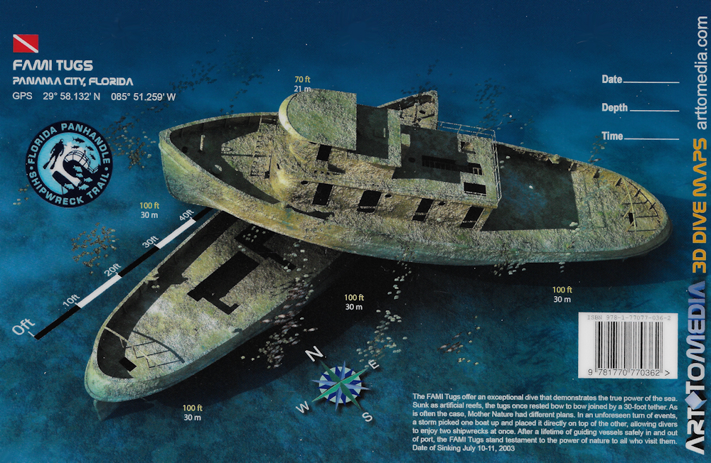
The FAMI Tugs offer an exceptional dive that demonstrates the true
power of the sea. Sunk as artificial reefs, the tugs once rested bow to bow joined by a 30-foot tether. As is often the case, Mother Nature had different plans. In
an unforeseen turn of events, a storm picked one boat up and placed it directly on top of the other, allowing divers to enjoy two shipwrecks at once. After a lifetime
of guiding vessels safely in and out of port, the FAMI Tugs stand testament to the power of nature to all who visit them.
This site is part of the
Florida Panhandle Shipwreck Trail.
Markers - None.
Details - One tug sits on top of the other to form a T.
Marine Life - Barracuda, shark, triggerfish, amberjack, angelfish.
Recommended Certifications - Open Water, Advanced Open Water, Enriched Air (Nitrox), Boat, Deep, Drift, Multi-Level, Peak Performance Buoyancy, Wreck, Coral
Reef Conservation. |
|
|
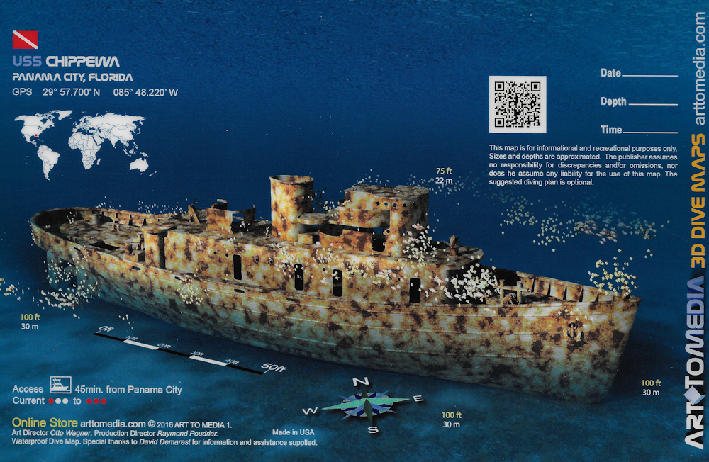
5 |
 |
Wreck |
Intermediate - Advanced |
29°57.700 N
85°48.220 W |
100' |
|
| |
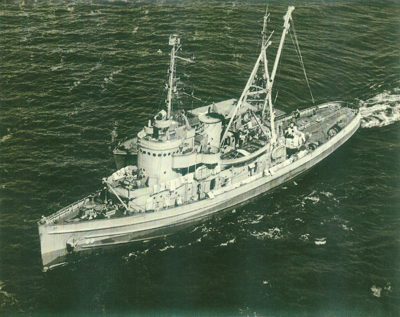
Launched by the Charleston Shipbuilding and Dry Dock Company on
July 25, 1942, the Chippewa is Navajo class fleet tug. Her purpose was to aid ships, usually by towing, on the high seas or in combat or post-combat areas.
Commissioned on February 14, 1943, she then sailed to Casablanca to lay buoys in May and June, returning to Boston in on June 26.
After an overhaul, she
was assigned to duty in the Caribbean Sea Frontier making Trinidad, British West Indies, her principal base until May 6, 1944. When she returned to Norfolk for repairs
on May 15, she was reclassified ATF-69. She returned to Trinidad until March 1945. Later that year, she made a long towing voyage Boston to Bermuda to Norfolk with the
SS War Bonnet in tow.
On February 26, 1947, she was decommissioned and sent to Orange, Texas where she remained in the Reserve Fleet until transferred to
the Maritime Administration in Beaumont. Chippewa was struck from the Naval Vessel Register on September 1, 1961. She remained in Beaumont until August 17, 1989, when
she was returned to the Navy to be prepared to be sunk as an artificial reef. Chippewa was sunk on February 8, 1990, by a network of 37 explosive charges.
This site is part of the Florida Panhandle Shipwreck Trail.
Markers - None.
Details - Vessel sits upright in just over 100' of water. There are plenty of swim throughs to explore.
Marine Life - Large amberjack, barracuda, snapper and grouper.
Recommended Certifications - Open Water, Advanced Open Water, Enriched Air (Nitrox), Boat, Deep, Drift, Multi-Level, Peak Performance Buoyancy, Wreck, Coral
Reef Conservation. |
|
|
|
|
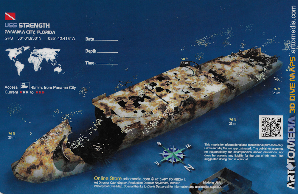
6 |
 |
Wreck |
Intermediate - Advanced |
30°1.936 N
85°42.413 W |
80' |
|
| |
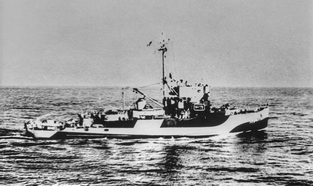
An Admirable class minesweeper put into service in March of 1944,
Strength is 184 feet long with a beam of 33 feet. She was built by Associated Shipbuilders of Seattle, Washington. With twin screws and two diesel-electric engines,
she had a total of 1,800 HP, and could reach speeds of 15 knots.
Officially commissioned in September 1944, she completed her shakedown cruise and
reported to Iwo Jima on February 16, 1945. She began sweeping operations to clear the waters for the invasion fleet which arrived on September 19, 1945. The
following month, the Strength was attacked by a partially surfaced Japanese midget submarine. Two torpedoes passed underneath her and the gun crews drove off the
sub without apparent damage.
In March, the minesweeper worked to clear the approach to Okinawa. After the initial assault, the Japanese countered
with heavy kamikaze suicide planes. When chosen as a target, the gun crews of the Strength downed the Japanese plane before it could hit the ship. She received
three battle stars for her service during World War II. Decommissioned and placed in reserves on July 19, 1946, she was then reclassified as a Fleet Minesweeper
(Steel Hull), MSF-309, on February 7, 1955 and struck from the Navy list on April 1, 1967.
She was then sent to the Naval Diving and Salvage Training
Center to be used as a training hull. Thousands on Navy salvage divers began their careers by doing the work and calculations necessary to bring the Strength back
to the surface.
In 1987, she was patched for one more trip offshore and Navy EOD divers sent her down for the last time. Unfortunately, she ended up
on her side until a hurricane set her upright in 1995.
This site is part of the Florida Panhandle Shipwreck Trail.
Markers - None.
Details - The bow has been separated from the rest of the ship by about 80 feet.
Marine Life - Large amberjack, barracuda, snapper and grouper.
Recommended Certifications - Open Water, Advanced Open Water, Enriched Air (Nitrox), Boat, Drift, Multi-Level, Peak Performance Buoyancy, Wreck, Coral Reef
Conservation. |
|
|
|
|
7 |
Vamar |
Wreck |
Novice |
29°53.941 N
85°27.806 W |
25' |
|
| |
Originally named Kilmarnock, this steamer was built in 1919 in
England as a patrol gunboat. Shortly after launching she was renamed Chelsea. When the British government confiscated the ship for smuggling liquor, Admiral
Richard E. Byrd purchased her, renaming her Eleanor Bolling, after his mother.
She is most famous for carrying the Admiral's American expedition
to Antarctica in 1928. She brought supplies to the polar base including the airplanes that made the first aerial flyover of the South Pole. After the expedition,
the Admiral sold the vessel to an Arctic sealing company and in 1933 she was purchased by the Vamar Shipping Company.
She was then used to haul
supplies along the Gulf Coast as a tramp freighter. Under mysterious circumstances, she was sank while leaving Port St. Joe, carrying lumber to Cuba in 1942.
This site is part of the Florida Panhandle Shipwreck Trail.
Markers - None.
Details - Vamar was 170 feet long with a beam of 30 feet.
Marine Life - Large amberjack, barracuda, snapper and grouper.
Recommended Certifications - Open Water, Advanced Open Water, Enriched Air (Nitrox), Boat, Drift, Peak Performance Buoyancy, Wreck, Coral Reef Conservation. |
|
|
|
|
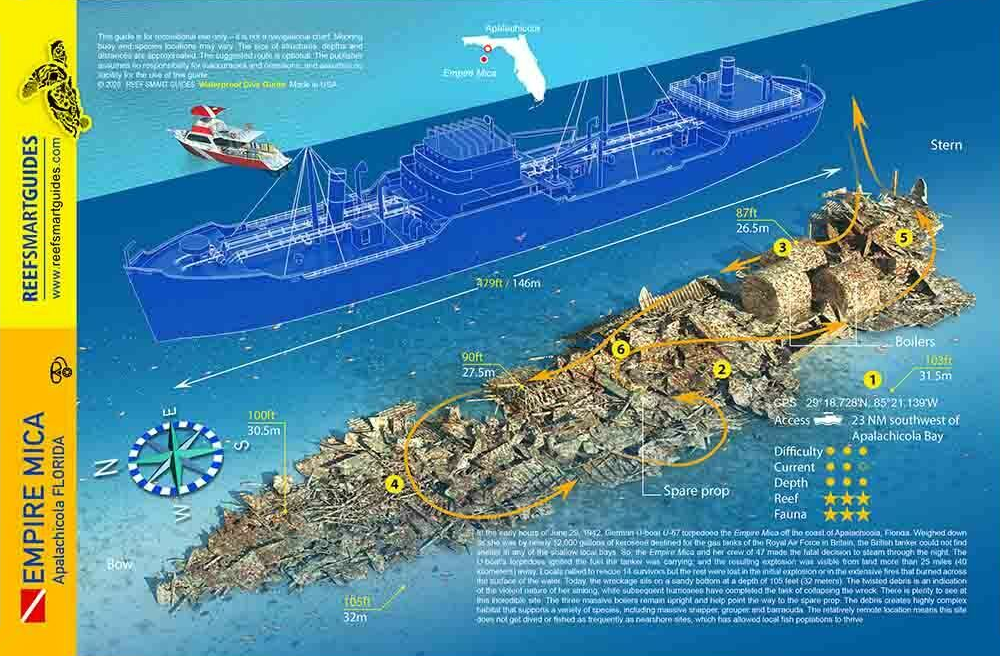
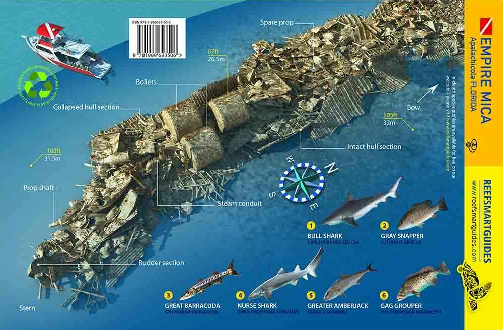
8 |
Empire Mica |
Wreck |
Advanced |
29°18.682 N
85°21.228 W |
110' |
|
| |
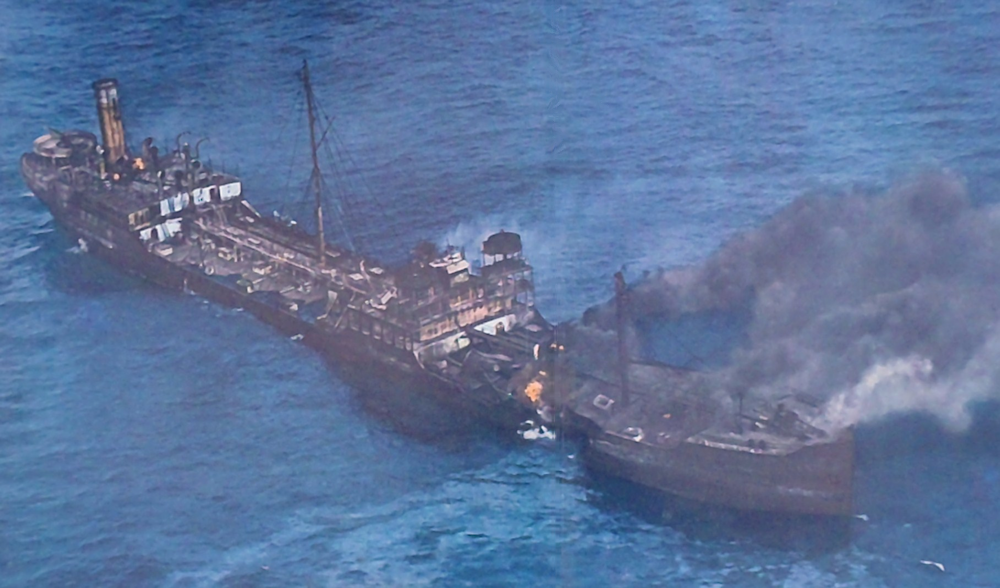
The Empire Mica was built in 1941 at the Furness Shipbuilding Yard
in Howeston-on-tees, England. Although owned by the Ministry of War Transportation, she was leased to the Anglo-American Oil Company. At 465 feet long and 61 feet
wide with a gross tonnage of 8,032, she was in the size category of the largest tankers of the era.
In June 1942, in Baytown, Texas, the Mica was
loaded with 11,200 tons of petroleum distillate and began the long journey home on her maiden voyage. Submarine sightings had been reported all along the Gulf
Coast so the plan was to anchor for the night in either St. Andrews or St. Joseph Bay. Because of her load, the Mica was drawing too much water to enter either
bay. The decision was made to continue south, following the ten-fathom curve which would keep submarines at a disadvantage due to the shallow water. This proved
to a fatal mistake.
It was a peaceful, moonlit night, June 29, 1942, when the Mica cleared the shallows off Cape San Blas. As she headed southeast,
the quiet was shattered and war struck home, a mere 21 miles from Apalachicola, Florida. Two torpedoes struck the Mica on her portside, just about amidships. Flames
leaped high and the explosions were heard for miles and miles up the Gulf Coast.
While the ship burned and exploded, private boaters from Apalachicola
sped to the rescue. Despite all efforts, 33 of the 47 crew members were lost. After more than 24 hours of burning and drifting, the Mica finally sank in 105 feet of
water just southeast of Cape San Blas.
This site is part of the Florida Panhandle Shipwreck Trail.
Markers - None.
Details - In 1983, the propeller was removed by a crew using explosives in the hopes of selling it. Due to the explosions, the after deck, where the main
propeller served as a backdrop for photographers, is now lying on the bottom, reduced to a pile of scrap metal. Luckily, the other deck areas are still intact and
can dwarf a diver as they rise majestically from the bottom. The propeller is now on display outside of Captain Anderson's Restaurant in Panama City.
Marine Life - Large amberjack, barracuda, snapper and grouper.
Recommended Certifications - Open Water, Advanced Open Water, Enriched Air (Nitrox), Boat, Deep, Drift, Multi-Level, Peak Performance Buoyancy, Wreck, Coral
Reef Conservation. |
|
|
|
|
|
|
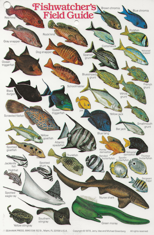
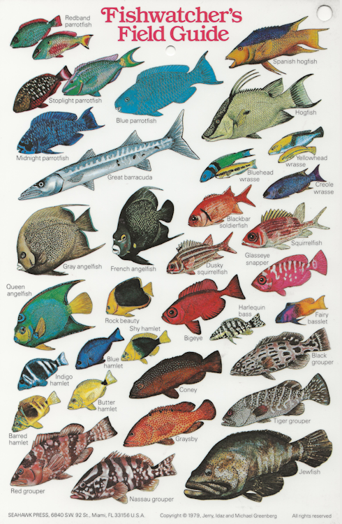
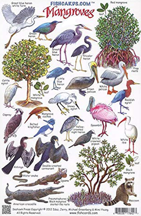
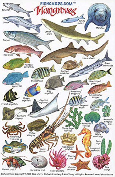
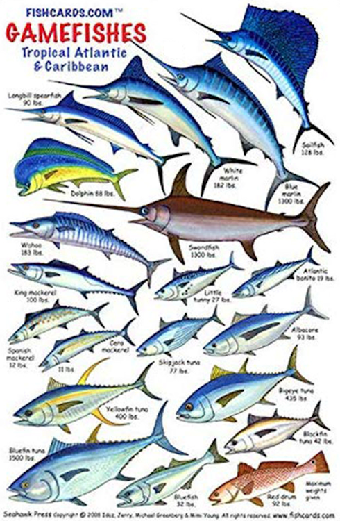
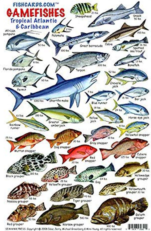
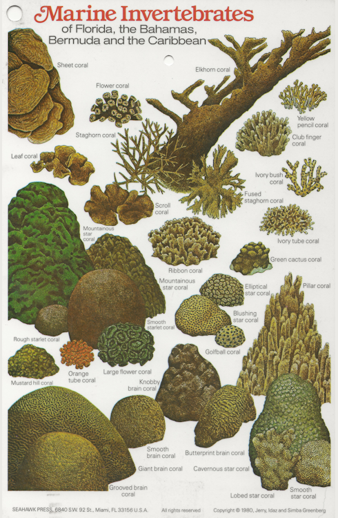
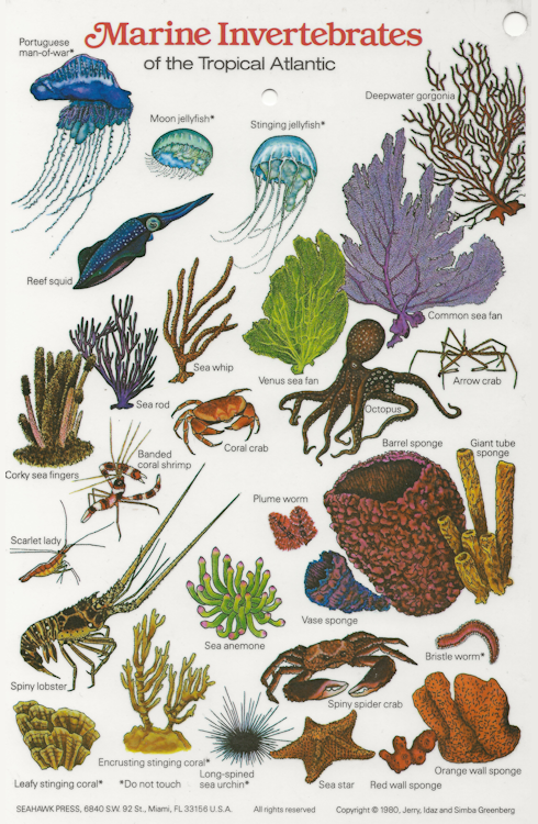
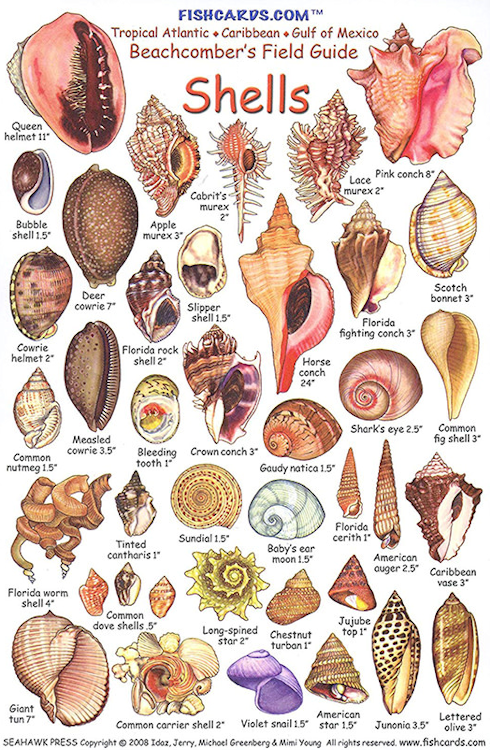
Reef and Fish Cards |
| Since there are thousands of different species of fish and coral, these ID cards will help you identify what you see under the ocean. |
|
|
|
|
|
|
|
|
|
|
|
|