|
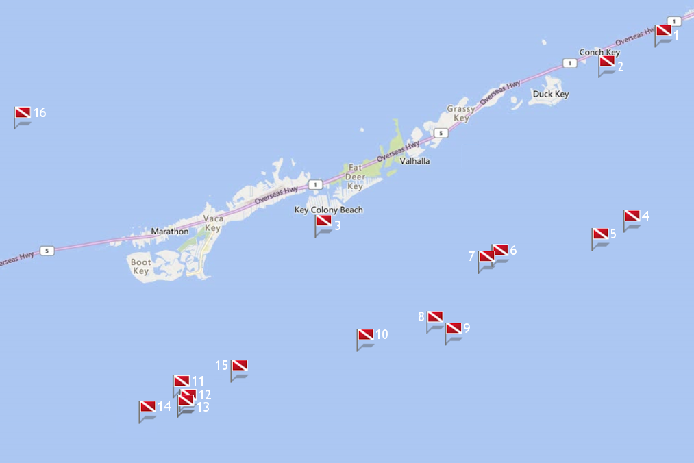
Site Name |
Dive Type |
Difficulty |
GPS |
Max Depth |
Map |
|
1 |
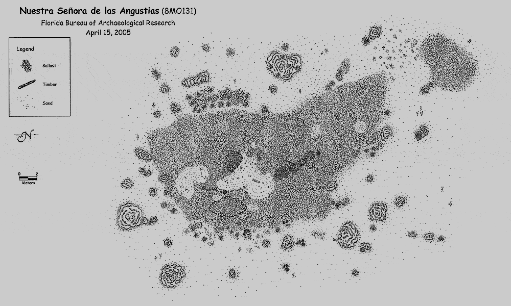
Angustias |
Wreck |
Novice |
24°47.455 N
80°51.738 W |
15' |
|
| |
The Angustias wreck, officially the Nuestra Señora de las Angustias (Our Lady of the Anguishes),
is also referred to as El Charanguero Grande (the Great Coastal Trader) or the San Rafael and is another of the ill fated ships that sailed with the doomed 1733 Spanish
Treasure Fleet. This vessel, captained by Don Francisco Sanchez Madrid, was positioned near the rear of the Flota, and sailed with the Almiranta and El Sueco de Arizón.
The hurricane was so violent that the top of the masts were ripped off by the the wind, tangling them in the mainsail. The towering waves were so forceful that they
pushed the ship onto her side, tossing her 4 cannons and some of her cargo overboard.
In an effort to keep the ship afloat, the crew cut down her
masts but the strength of the storm proved too much. The combination of wind and waves from the hurricane forced the ship over the sharp, jagged coral reefs and into
shallow water.
This Spanish ship grounded and sank in only 15 feet of water off Long Key, in Long Key Channel. The fate of her other two traveling
companions, the Almiranta and El Sueco de Arizón was equally disastrous as they grounded nearby.
Fortunately all of her crew were saved, but the
valuables which had stayed on board were in peril. The 328.5 ton merchant vessel carried a precious cargo typical of the rest of the Flota. In her holds were
indigo and cochineal, along with silver pesos, and popular Chinese porcelain. The dye on board would have been easily damaged by the incoming flood of water, but
the crew was able to salvage much of what they carried, including personal items.
Today there's not much left of the Angustias wreck. As with most of the
ships that traveled with the 1733 Fleet, the Spaniards did a good job of salvaging their treasure. Centuries later, modern treasurer hunters also scoured these
shipwrecks looking for any artifacts that had been left behind. With it's typical wood construction, very little of this treasure ship's structure is left. Basically
the only thing that remains of the Angustias wreck is a portion of the keel which is covered by her ballast.
Markers - None.
Details - Eel hideout in the ballast pile, numerous large sharks cruise the area. Currents are strong, silt is heavy and visibility is usually poor.
Marine Life - Eel, sharks, coral heads, purple sea fans, sea whips, ocean sponges, yellowtail, barracuda, angelfish, parrotfish.
Recommended Certifications - Open Water, Advanced Open Water, Enriched Air (Nitrox), Boat, Drift, Peak Performance Buoyancy, Wreck, Coral Reef Conservation. |
|
|
2 |
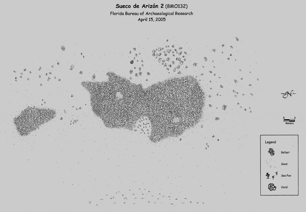
El Sueco de Arizón |
Wreck |
Intermediate - Advanced |
24°46.636 N
80°53.367 W |
9' |
|
| |
El Sueco de Arizón was the smallest ship
traveling with the ill fated 1733 Spanish Treasure Fleet. In typical Spanish fashion her given name was lengthy. She was the Nuestra Señora del Rosario Santo
Domingo, San Antonio y San Vincente Ferrer. However since she was built in Sweden, the nickname she was most often referred to was Sueco. In Spanish, this means
"Swedish like, or acting like a Swede".
When the hurricane struck, she was at the rear of the Flota with the Almiranta and the Angustias. Unable
to outrun the hurricane, she and the others in the fleet were forced westward over the sharp and jagged coral reefs. When she grounded, she was in less than 9
feet of water off Conch Key. Her sails were tattered, her mast broken, and her rudder ripped from her stern.
Considering the force of the hurricane,
the water washing over the decks, the listing of the small ship, it's incredible that all of her crew survived. Another amazing fact is that her crew was able to
save most of her cargo which consisted of furs, Chinese porcelain, silver pesos, indigo, cochineal and tobacco.
Where she came to rest is an area
that's also plagued by strong currents. To have escaped the storm, only to fight the current, would have been an additional hardship the already weary and terrified
crew wouldn't have expected. Over the centuries, the strong current and numerous tropical storms and hurricanes have broken this small ship up, moving her remnants
over a greater swath. When you get to this diving site you'll also discover her egg shaped ballast. It's spread over two adjacent areas, piled around the turtle
grass and it also leads to shore.
Markers - None.
Details - Strong current with poor visibility. Remains are of two circular piles of egg shaped ballast along with a small trail of ballast leading towards shore.
Marine Life - Lobster, grunt, angelfish, shark, yellowtail, barracuda.
Recommended Certifications - Open Water, Advanced Open Water, Enriched Air (Nitrox), Boat, Drift, Peak Performance Buoyancy, Wreck, Coral Reef Conservation. |
|
|
3 |
Brick Wreck |
Wreck |
Novice |
24°42.706 N
81°1.619 W |
12' |
|
| |
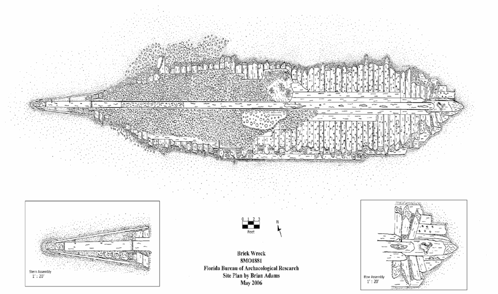
Believed to be of New England origin, this 19th
century wooden schooner was traveling south when she foundered on the Florida Keys coral reefs. When the research team conducted their archaeological and biological
examination of this ship in 2006, they determined that it's excellent condition must have been due to the fact that she had been buried beneath the sand, brick and
ballast for many years. During the study, the archaeologists uncovered many different pieces of ceramic shard, glass and glass bottles. The also found some of the red
bricks the schooner had been transporting. It's easy to spot her wooden hull, somewhat flattened ballast stones, bow, pieces of timber and posts, and numerous iron
objects.
Markers - None.
Details - Well preserved. Most of the bricks have been salvaged but remnants are scattered in the sand along with river rock and pea rock ballast. Pieces of the
wood ribs, bow, and keel are visible.
Marine Life - Spiny lobster, variety of sea grasses, goldentail moray eel, hogfish, cardinalfish, bluestriped grunt, white grunt, barracuda, porkfish,
anemone, grouper, tomtate, drum, triggerfish, snapper, nurse shark.
Recommended Certifications - Open Water, Advanced Open Water, Enriched Air (Nitrox), Boat, Drift, Peak Performance Buoyancy, Wreck, Coral Reef Conservation. |
|
|
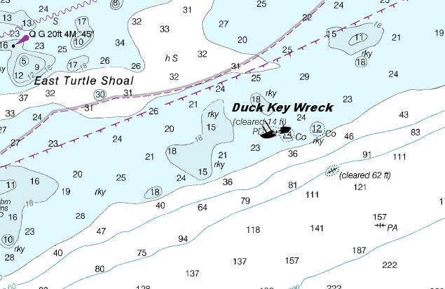
4 |
Duck Key Wreck |
Wreck |
Novice |
24°42.610 N
80°52.659 W |
25' |
|
| |
Other than the fact that she sank at Boiler
Patch in 1889, and was a steam powered freighter, little else is known about this vessel. The old freighter's 4 large coral encrusted smoke stacks and 2 boilers
rest in the white sand are popular with photo enthusiasts.
Markers - None.
Details - The wreck remains consist of 4 smoke stacks and 2 boilers scattered over the wreck area.
Marine Life - Soft and hard coral, sponges, damselfish, grouper, wrasse, nurse shark, eel, cardinalfish, grunts, angelfish, blue tang, yellowtail, barracuda,
parrotfish, spiny lobster.
Recommended Certifications - Open Water, Advanced Open Water, Enriched Air (Nitrox), Boat, Drift, Peak Performance Buoyancy, Wreck, Coral Reef Conservation. |
|
|
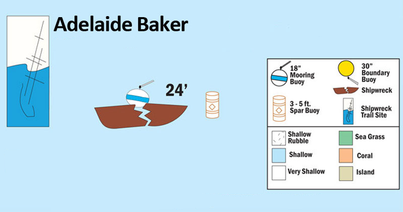
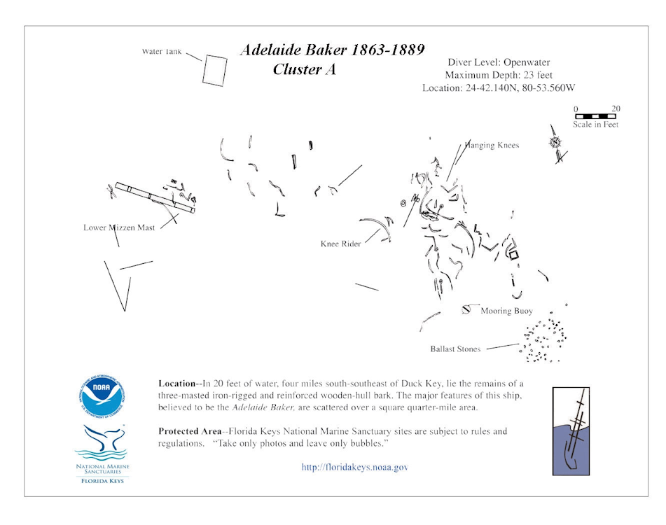
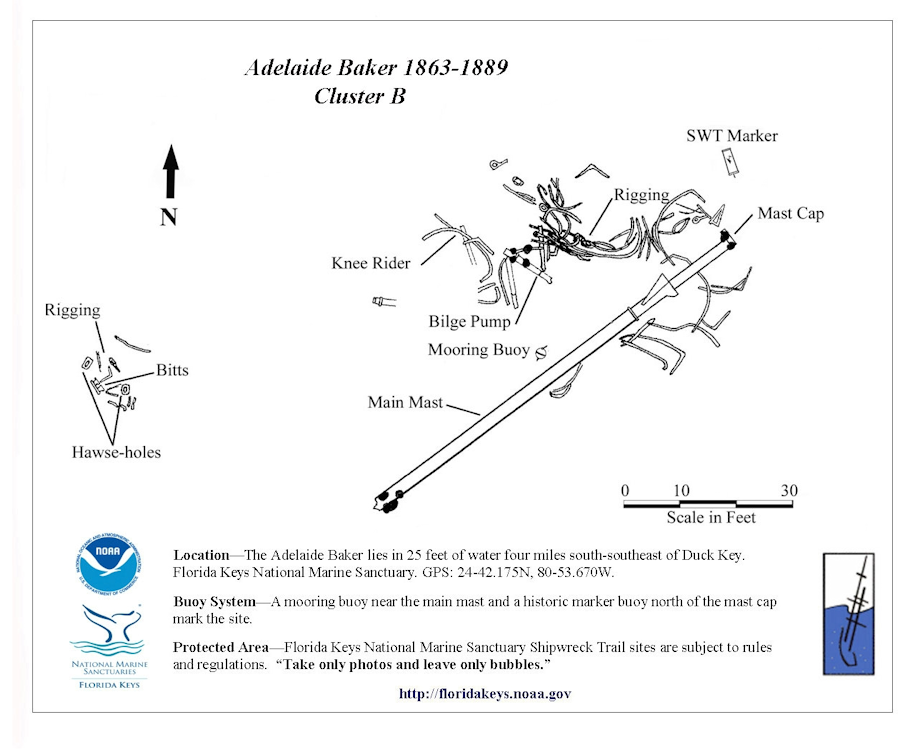
5 |
Adelaide Baker |
Wreck |
Novice |
24°42.140 N
80°53.560 W |
30' |
|
| |
The British owned Adelaide Baker was a 3 masted
copper plated barque originally named the F.W. Carver. Built in 1863, she had a length of 153 feet, with a 35 foot beam.
In January, 1889, while en route to
Savannah, Georgia she grounded at a reef called Porkfish which is a northern section of the Coffins Patch Reef cluster. Fortunately no one was killed in the wreck,
and her crew along with local salvagers, were able to rescue a portion of the lumber she carried on board.
At the primary wreck site is where her granite
ballast is concentrated because this is where she first grounded on the reef and spilled open. Scattered around this site you'll find wood and iron frames used in her
construction, along with a section of her mizzen mast and a metal water tank. At the secondary site, her 77 foot iron mast and rigging is found, along with her bilge
pump, tackle, pieces of iron frame, hawse holes where her anchor ropes passed, and another water tank nearby.
Situated at the north end of Coffins
Patch with it's cluster of 6 reefs, this is a less trafficked area. The San Ignacio, which was part of the ill fated 1733 Spanish Treasure Fleet is also nearby.
Markers - Spar buoy.
Details - Ship remains are scattered over a 1400' area. Site #1 is where the ship originally grounded. Site #2 is where salvagers most likely have relocated
various sections of the vessel.
Marine Life - Grouper, porkfish, nurse shark, barracuda, yellow tail snapper, coral, moray eel, spiny lobster, ocean sponge, parrotfish, angelfish, blue tangs,
sea fans.
Recommended Certifications - Open Water, Advanced Open Water, Enriched Air (Nitrox), Boat, Drift, Peak Performance Buoyancy, Wreck, Coral Reef Conservation. |
|
|
|
|
|
6 |
San Ignacio |
Wreck |
Novice |
24°41.700 N
80°56.440 W |
18' |
|
| |
The San Ignacio wreck was one of the 1733
Spanish Treasure Fleet ships that went down during the night of the hurricane. Often considered a true treasure ship, this 292 ton British built vessel also has
the least amount of information available. According to the State of Florida Bureau of Archaeological Research, they cannot 100% confirm the identity of this wreck.
What is known from manifests is that she carried a cargo of 12,000 pesos in silver and bullion. She also had on board 696 marcos, which translates to about
1,372 pounds of worked silver. We know that her official name was Sumey de San Ignacio, and that she carried onboard her owner Urquijo. He also owned the San Francisco
which was traveling with the Flota. Out of the 52 people onboard, he became one of that night's 38 casualties.
The initial impact of the hurricane almost
gutted her, spewing out some of her cannons and anchors. As she was dragged and scraped across the mile of sharp jagged coral beneath her, she left a trail of silver,
precious treasures, and bodies in her wake.
Unlike the gruesomeness of that fateful night, today a visit to this wreck dive site is quite rewarding.
There's always the possibility of finding a silver coin or other treasure, but this wreck is in protected waters as it lies within the Florida Keys National Marine
Sanctuary. There is a very strict "look but don't touch policy" when it comes to these national treasures.
Markers - None.
Details - Remains are scattered over a wide, grassy area of Coffins Patch Reef. Numerous silver coins and some gold coins have been found in the area.
Marine Life - Nurse shark, angelfish, blue tang, yellowtail snapper, grunts, parrotfish, green moray eels, squirrelfish, spiny lobster, coral, sponges.
Recommended Certifications - Open Water, Advanced Open Water, Enriched Air (Nitrox), Boat, Drift, Peak Performance Buoyancy, Wreck, Coral Reef Conservation. |
|
|
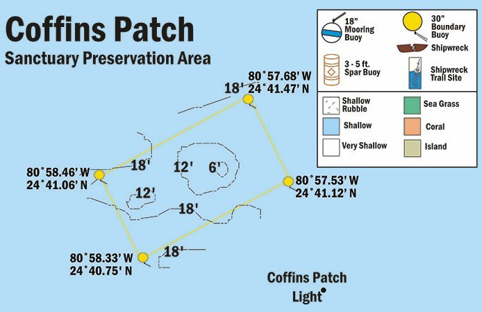
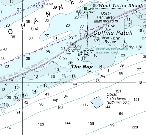
7 |
Coffins Patch Reef |
Reef |
Novice |
24°41.540 N
80°56.846 W |
40' |
|
| |
The overall area is composed of 6 different
reefs, each sporting a predominantly different coral. This feature alone makes an exploratory trip out to this site worthwhile. Out of all the
coral reefs that make up this dive site, the "Stake" is the easiest to identify. Jutting out of it's oval shape is an iron pole, hence it's name. At the west end
of the Stake the depth reaches about 25'. Plus at the Outer Edge reef it drops to a depth of about 40'.
Markers - SPA protected area so there are 4 yellow markers around the Stake area. There are also 8 mooring buoys around the area marked CP0 - CP7.
Details - This Florida coral reef runs 1.5 miles northeast and southwest and is comprised of 6 different reef structures.
Marine Life - Nurse sharks, butterflyfish, green moray eel, barracuda, blue tangs, angelfish, grouper, lobsters, jacks, yellowtail, sponges, different types
of coral including fairly tall pillar coral, star coral, very large brain coral, elkhorn coral, fire coral.
Recommended Certifications - Open Water, Advanced Open Water, Enriched Air (Nitrox), Boat, Drift, Multi-Level, Peak Performance Buoyancy, Coral Reef Conservation. |
|
|
8 |
The Gap |
Reef |
Novice - Intermediate |
24°39.960 N
80°58.310 W |
80' |
|
| |
The Gap is a mid to deep dive that is aptly
named as one does exist in the shelf. It starts at around 50 feet and rapidly slopes downward 30 vertical feet. Since the site has a rather strong current, drift
diving can be quite good here. As you descend the rapid slope of the wall, you'll be able to see a good assortment of larger sponges. The deeper levels also will
produce a better variety of game fish and other species including sunshine fish that you don't usually see at the shallower reef sites.
Markers - None.
Details - This Florida Keys diving site has a wall located on the outside that drops off rather rapidly. This is a particularly good dive site for ledge or
drift diving because of the strong current. The inside of this Florida Keys coral reef has a gradual slope and is better for novice divers and snorkelers.
Marine Life - 10 - 15' high coral heads, numerous tropical and game fish, ocean sponges, jacks, barracuda, yellowtail, star coral, wrasses, schoolmasters,
grunts, sea fans and plumes. Deeper levels you can see the larger game fish and pelagic species, spiny lobster.
Recommended Certifications - Open Water, Advanced Open Water, Enriched Air (Nitrox), Boat, Drift, Multi-Level, Peak Performance Buoyancy, Coral Reef
Conservation. |
|
|
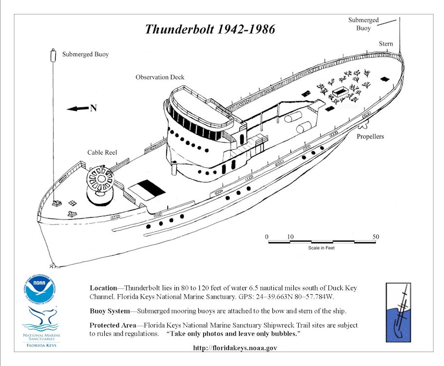
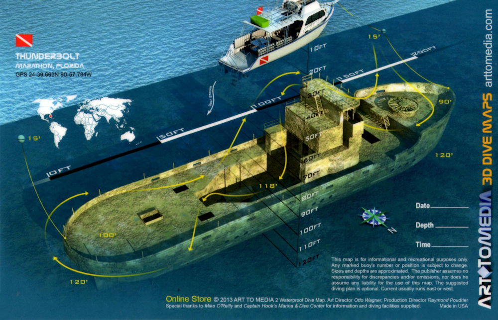
9 |
Thunderbolt |
Wreck |
Intermediate - Advanced |
24°39.663 N
80°57.784 W |
120' |
|
| |
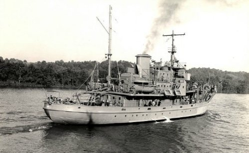
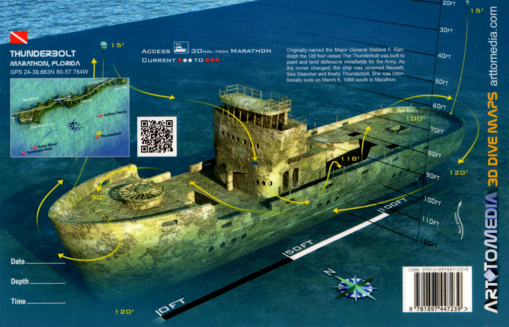
The Thunderbolt Wreck is formerly known as the USAMP
Major General Wallace F. Randolph. She was a cable minelayer with a length of 188 feet and a 32 foot beam.
Built in 1942, she worked as a mine planter for
the Army until she was transferred to the Navy in 1951. She continued her work under various classifications as a mine layer, even undergoing several name changes
including ACM-15, MMA-15 and the Nausett.
Within a few years she was moved to the Reserve Fleet in Green Cove Springs, Florida, and on July 1, 1960,
she was stricken from the register. Less than a year later she was sold to an oilfield exploration company who renamed her the Sea Searcher. Eventually Caribbean
Enterprises sold her to the Florida Power and Light Company who deployed her as part of their lightning strike research program. Florida is one of the heaviest hit
areas for lightning strikes and as part of their study, rockets with trailing conductive wires were fired into thunder heads forcing lightning strikes. The strikes
were then analyzed by the equipment on board the ship. These techniques were quite successful in generating strikes, so much so that in August, 1966, on just one day
they produced 17. The strikes she took, earned her the name of Thunderbolt.
By the early 1980's she was ready to start working as an underwater
surveyor vessel but while docked at Miami Harbor she sank. The years of lightning strikes had weakened her and taken their toll. With no future ahead, interested
parties from the Florida Keys Artificial Reef program made arrangements to have her properly prepped, and on March 6, 1986 she was scuttled off Vaca Key, 5 miles
offshore of Marathon.
Today, the Thunderbolt reigns as the signature dive for divers with advanced scuba diving certification in the Marathon Key area.
Resting at a depth of 120 feet on a flat sandy bottom, this nearly intact ship has become the perfect artificial reef.
Areas you won't want to miss
exploring include her twin propellers, and her anchor chain which extends west off the port side toward several debris piles. The different holds and compartments
including the wheelhouse, the engine compartment, and the stairwell leading to crews quarters are easily accessible. Plus, throughout the ship, there are numerous
points of entry and egress making this dive spot more accessible than most. Of course one of the most photographed and recognizable features of the Thunderbolt wreck
is the large horizontal wheel located on her bow that was used for laying mines. This wheel has become heavily encrusted and large fish like to congregate in this area.
Markers - No markers. 2 mooring buoys in about 25' water at the stern and the bow. Lines run to the wreck to help with the sometimes strong current.
Details - Covered with coral, sponge and silt, she sits upright in 120'. At 75' you encounter an observation deck, at 85' the bow is reached where the
horizontal cable reel is located. At the main deck, large hatches make it possible to descend to the engine compartments down to 110' in the hull. At 120' the
propellers and rudder are encountered. Currents can be very strong at this site.
Marine Life - Variety of sea sponges, stony and gorgonian coral, goliath grouper, large angelfish, amberjack, black grouper, barracuda, silversides, tarpon,
hogfish, mackerel, shark, pompano, permit, mutton snapper, sailfish, conch.
Recommended Certifications - Open Water, Advanced Open Water, Enriched Air (Nitrox), Boat, Deep, Drift, Multi-Level, Peak Performance Buoyancy, Wreck, Coral
Reef Conservation. |
|
|
|
|
|
|
|
|
|
10 |
Samantha Reef |
Reef |
Novice |
24°39.494 N
81°00.316 W |
25' |
|
| |
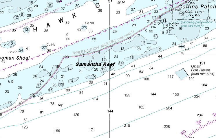
At Samantha Reef, you may have to spend more
time feeding sharks than diving. The marine life at this site have actually become rather "friendly". The small group of nurse sharks and stingrays in the area
will come up to you expecting their daily hand out.
This dive site has a long ledge that spans a depth of about 15 - 25'. The ledge is rather like
a winding path you can follow along as you explore the crevices. Along this "path" you'll encounter numerous schools of fish and see a variety of coral and crustaceans.
Markers - None.
Details - This coral reef is closer to the drop off than most of the other reefs so visibility can be better. Long ledge to follow along and
look for marine life.
Marine Life - Nurse shark, coral including brain and starlet, grunts, stingrays, yellowtail, chub, barracuda, surgeonfish.
Recommended Certifications - Open Water, Advanced Open Water, Enriched Air (Nitrox), Boat, Drift, Peak Performance Buoyancy, Coral Reef Conservation. |
|
|
11 |
North America |
Wreck |
Novice |
24°38.270 N
80°05.605 W |
14' |
|
| |
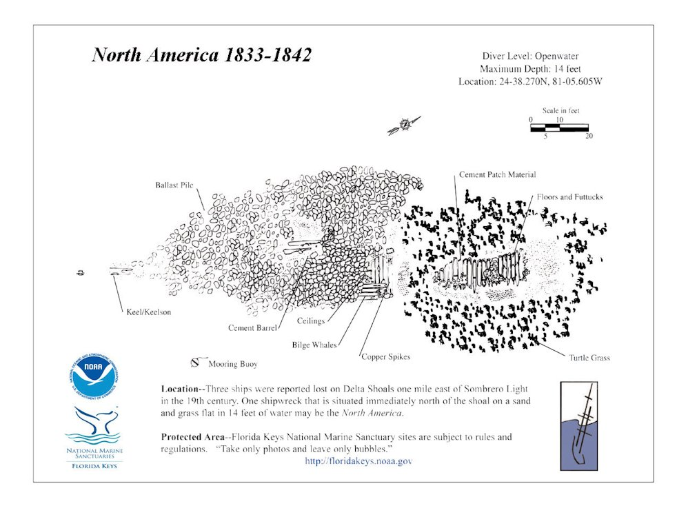
Without her identity being fully confirmed,
it's believed she's the 130 foot long, 29 foot beam, vessel christened the North America. This ship was a 2 deck, 3 masted, square rigged vessel built in Maine
in 1833. On November 25, 1842, while en route from New York to Mobile, Alabama she grounded on a coral reef north of Delta Shoal. Captain Hall, her
crew, along with the furniture and dry goods she carried were later safely rescued by salvagers.
Resting in 14 feet of water, what's left of this
shipwreck's remains cover a 112 foot long by 35 foot wide debris field. The remnants are primarily nestled in sand, surrounded by an assortment of sea grasses.
You'll notice that stone ballast makes up the largest portion of the wreck site. Her ballast also primarily lies within what's left of her wooden hull. This pile
stretches about 85 feet in an oval shaped pattern.
Most of her keel is buried beneath the ballast, but at the southwest end of the pile, a portion
of her keel and iron drift bolts are visible. In the middle of the debris pile is a cement barrel and another barrel can be seen at the north end. At the southeast
end of the pile are some pieces of ceiling lumber, copper spikes and pieces of cement used to patch the materials together. Further to the east surrounded by
turtle grass you'll encounter more cement patch material and pieces of timber.
Markers - Spar buoy, Mooring buoy.
Details - Majority of shipwreck is buried under sand and grass, with small sections of the wood hull filled with ballast being visible. Copper
spikes and 2 cement barrels, along with several planks and iron bolts attached to keel remnants.
Marine Life - Coral, wrasse, barracuda, angelfish, parrotfish, yellowtail, grunts, nurse shark, moray eels.
Recommended Certifications - Open Water, Advanced Open Water, Enriched Air (Nitrox), Boat, Drift, Peak Performance Buoyancy, Wreck, Coral Reef Conservation. |
|
|
|
|
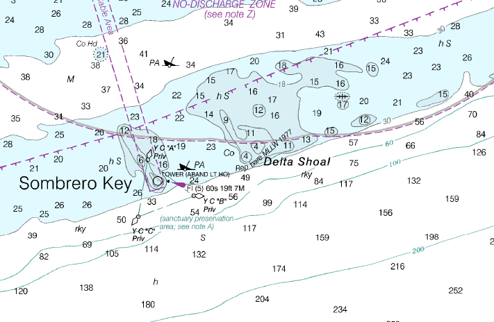
12 |
Delta Shoal Reef & Barge |
Reef |
Novice |
24°37.919 N
81°05.434 W |
25' |
|
| |
Delta Shoal is a very shallow dive site making it much better for snorkeling. However, it does have some
unusual aspects that can make it rather intriguing for a diver.
First, it's shape is different in that there are numerous long coral fingers
stretching out with sandy areas in between. This unusual feature makes snorkeling and diving the reef more interesting as there's numerous nooks and crannies to
explore. This site is also the location of several important shipwrecks that make it worth a diver's visit.
You'll find the barge on the east side
of the shoal and covered in coral. Unfortunately there's very little to no history about the barge.
Markers - None.
Details - Minimal current at this east and west running good spur and groove formation. Numerous coral canyons and plenty of fish hiding out
beneath ledges. Fingers of coral stretch out for half a mile with sandy channels in between.
Marine Life - Reef appears to be somewhat of a nursery for the fish that hang out under the ledges and in the crevices. Grunts, yellowtail,
angelfish, barracuda, sponges including elephant ear sponges, elkhorn, brain and star coral, rock beauties, moray eels, nurse shark, spiny lobster.
Recommended Certifications - Open Water, Advanced Open Water, Enriched Air (Nitrox), Boat, Drift, Peak Performance Buoyancy, Coral Reef Conservation. |
|
|
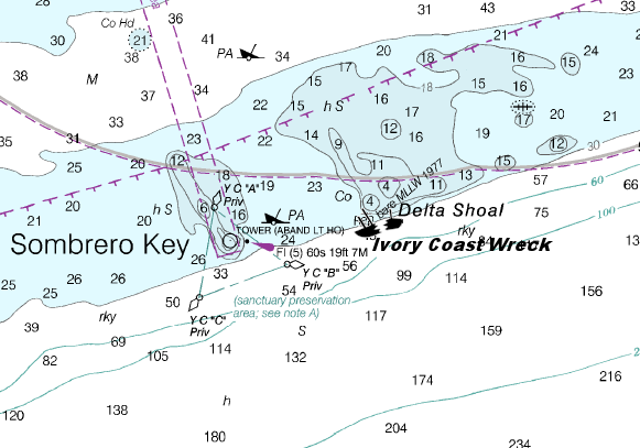
13 |
Ivory Coast Wreck |
Wreck |
Novice |
24°37.780 N
81°5.490 W |
15' |
|
| |
Believed to be a slave ship, the identity of
this schooner which sank in 1853 is still unknown. A marked cannon bearing the engraving JN 170 1/11 24 was found at the site, but this has not yet helped determine
the ship's name. When the Ivory Wreck was discovered, divers also found 12 elephant tusks ranging in length from 4 to 6 feet. Other shipwreck artifacts included
silver bars, bars of iron, pewter spoons, coins, metal buttons, a heavy anchor, cannon balls and musket shot. However, the unfortunate discovery which confirmed
she was a slaver, were the leg irons and brass bowls, indicative of what was typical on a slave ship.
Located south of Vaca Key between Delta Shoal
and Sombrero Reef and Light, this slave ship rests in about 15 feet of water. There's also a 2 foot tall cement monument which was erected in honor of the slaves
who died chained together.
Markers - None.
Details - Ballast is mostly what remains. Scattered over the wreck area they're mostly buried under silt. Good dive and snorkel site.
Marine Life - Bluehead, surgeonfish, angelfish, grunts, parrotfish, nurse shark, squirrelfish, blue tang, barracuda, spiny lobster, coral, yellowtail.
Recommended Certifications - Open Water, Advanced Open Water, Enriched Air (Nitrox), Boat, Drift, Peak Performance Buoyancy, Wreck, Coral Reef Conservation. |
|
|
14 |
Sombrero Reef |
Reef |
Novice |
24°37.600 N
81°06.600 W |
60' |
|
| |
Sombrero Reef is a designated an SPA and
is one of the more popular diving and snorkeling destinations in the area. The area's name is derived from the 142' lighthouse which is located in the northern
section of the SPA region.
This large reef is a good example of a standard spur and groove coral reef formation. It also has one area in particular
that's a huge favorite. The arch is a large, limestone structure decorated with numerous colorful stony and gorgonian coral and sea sponges that's also teeming
with snapper, grunt and neon gobies. Also, because the light is able to penetrate the shallow waters, everything is given a brighter tone. This makes it one of
the best places to capture some absolutely amazing underwater photos.
Markers - 10 mooring buoys.
Details - Uneven bottom north of the light house has sandy ravines, large coral cliffs, currents can be strong.
Marine Life - Coral including large stands of elkhorn, brain, sheet, lettuce, sea fans, sea sponges, blue tang, angelfish, sea turtles, hogfish, large
numbers of yellowtail, barracuda, grunt, gobies, moray eels, grouper, conch beds in the grassy areas off the reef.
Recommended Certifications - Open Water, Advanced Open Water, Enriched Air (Nitrox), Boat, Drift, Multi-Level, Peak Performance Buoyancy, Coral Reef
Conservation. |
|
|
15 |
Flagler's Barge |
Wreck |
Novice |
24°38.645 N
81°4.310 W |
24' |
|
| |
Flagler's Barge was just one of the many vessels
used to carry supplies and equipment needed to help build the overseas railroad envisioned by Henry Flagler. Unfortunately during the building of Flagler's Overseas
Railway, 3 major hurricanes affected the region. Strong winds, and high seas forced the houseboats Flagler's workmen lived on to break free and sink as well as the
barges and steamships carrying supplies used in the construction process.
This 100 foot long and 30 foot wide barge sits on a sandy bottom at a
variable depth of about 11 - 24 feet. You'll find that her side plating has predominantly disintegrated, exposing her steel framework beneath. This makes her more of
a swim through, as there isn't much left of her structurally, except for her steel "I" beams of this somewhat triangular shaped barge.
Markers - None.
Details - Destroyed by one of the Florida hurricanes during the construction of the Henry Flagler Overseas Railroad. Much of the barge has corroded - leaving
steel "I" beams visibly supporting hull and deck sections.
Marine Life - Nurse shark, soft corals, fire coral, sponges, sea fans, snook, moray eels, yellowtail, barracuda, schoolmasters, parrotfish, wrasse, tarpon,
grunts, blue tang, angelfish, sea turtles, goatfish, damselfish, permit, yellow jack.
Recommended Certifications - Open Water, Advanced Open Water, Enriched Air (Nitrox), Boat, Drift, Peak Performance Buoyancy, Coral Reef Conservation. |
|
|
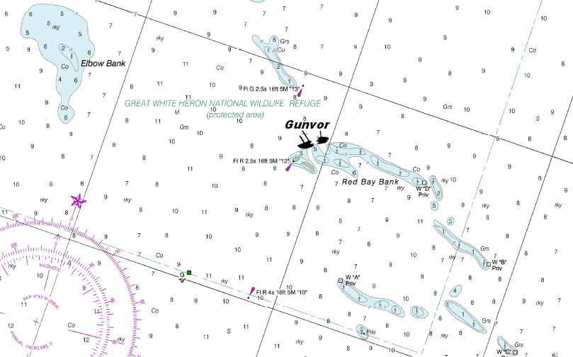
16 |
Gunvor |
Wreck |
Intermediate - Advanced |
24°45.300 N
81°10.180 W |
60' |
|
| |
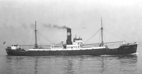
Built in 1935, the Norwegian steamship, Gunvor,
was just over 277 feet in length with a 43 foot beam. Locals also often refer to her as the Gumba or Gumbor. This is most likely due to the foreign sounding
Scandinavian pronunciation, and spelling of her name. Regarding her cargo, reports have indicated she was carrying cars, tractors and mail. There is a lot of
confusion as to not only her name, but her cargo, the date she sank, and what caused her to sink.
Some say she sank on June 10, 1942, and because
of a German torpedo from a U-boat. Others say it was June 15, 1942 and sank because she hit a mine.
What appears to be the case is that Captain
Lars Holm Brynildsen decided to shorten the distance by cutting off at Cape Sable and head due south until he picked up the 7 fathom curve north of the Florida
Keys. He felt that if he was in deep enough water it would be safe to travel after dark. Unfortunately we'll never know if his theory was correct or not, because
just after sunset, an explosion in the port side of the engine room occurred. Two seaman were killed and Captain Brynildsen was injured. The force of the explosion
was so great that within only a few minutes the Gunvor listed to port, and sank taking her cargo with her.
16 crew members made it into the starboard
lifeboat, and they were able to recover 4 more shipmates. Even though they believed they'd been attacked by U-boats, they spent over 90 minutes more looking for the
remaining crew. Finally when there was no hope that anyone else would be found, they left the scene and rowed 14 hours to Key West.
Even though she's
an intermediate dive at a depth of about 55 feet, she presents a number of difficult underwater dangers you need to be aware of. First, the visibility in the water
is usually limited to a short range of about 20 - 30 feet. She also wasn't a planned wreck, so she has a major number of ship entanglements that divers need to be
watchful of. Plus there's the danger that arises from the numerous fishing lines, nets, lures and even anchors that have been left behind after years of sportfishing
trips to the wreck. Then there's the sharks. Large bull sharks like to hang out at this site, and with limited visibility, you have to be extra cautious as this
shark species has a particularly nasty temperament.
Markers - None.
Details - Ship was sunk by a mine field. Remains are scattered.
Marine Life - Goliath and gag grouper, bluefish, blue runners, permit, pompano, snapper, barracuda, cobia, shark, jacks.
Recommended Certifications - Open Water, Advanced Open Water, Enriched Air (Nitrox), Boat, Drift, Multi-Level, Peak Performance Buoyancy, Wreck, Coral Reef Conservation. |
|
|
|
|
|
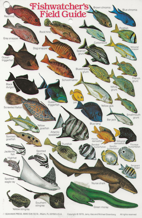
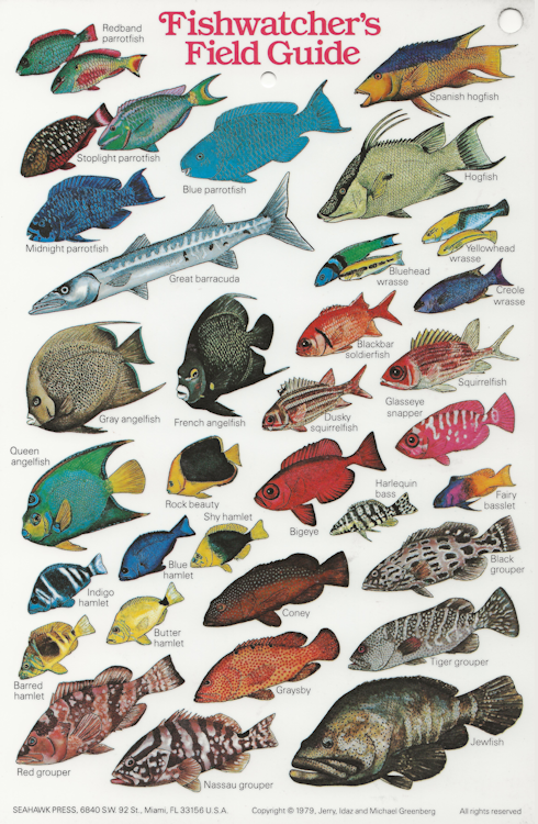
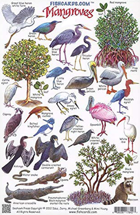
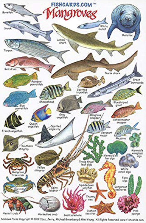
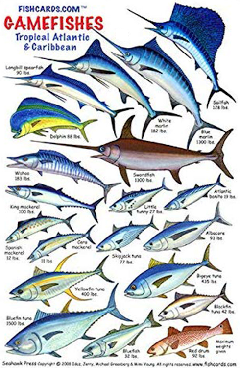
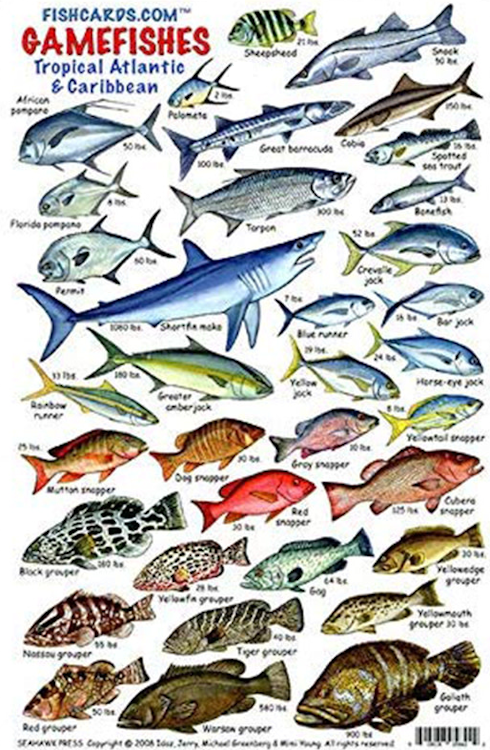
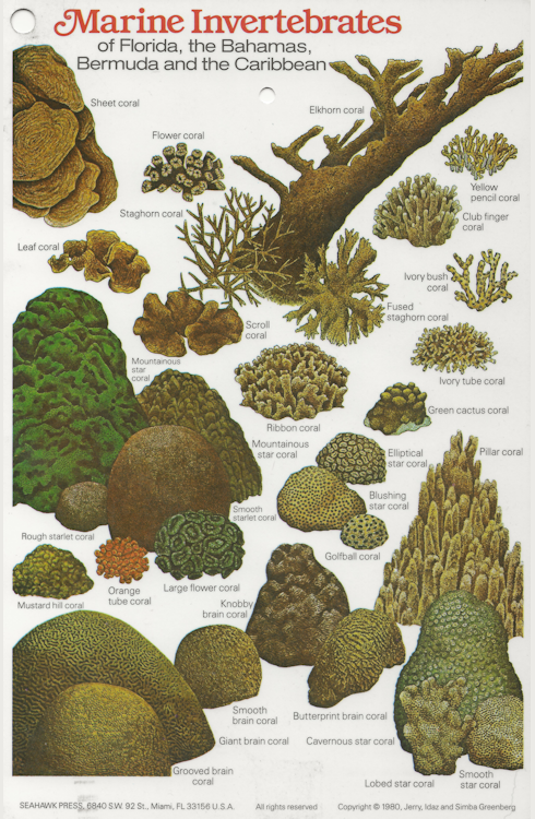
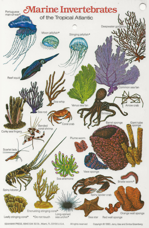
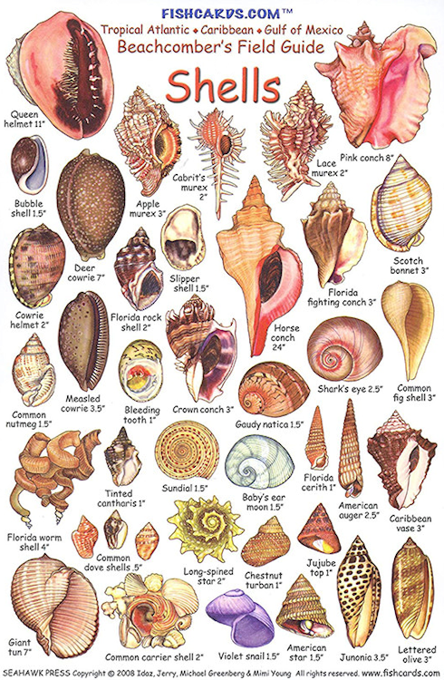
Reef and Fish Cards |
| Since there are thousands of different species of fish and coral, these ID cards will help you identify what you see under the ocean. |
|
|
|
|
|
|
|
|
|
|
|
|