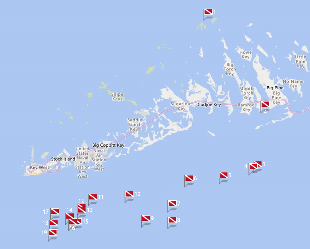
|
Site Name |
Dive Type |
Difficulty |
GPS |
Max Depth |
Map |
|
1 |
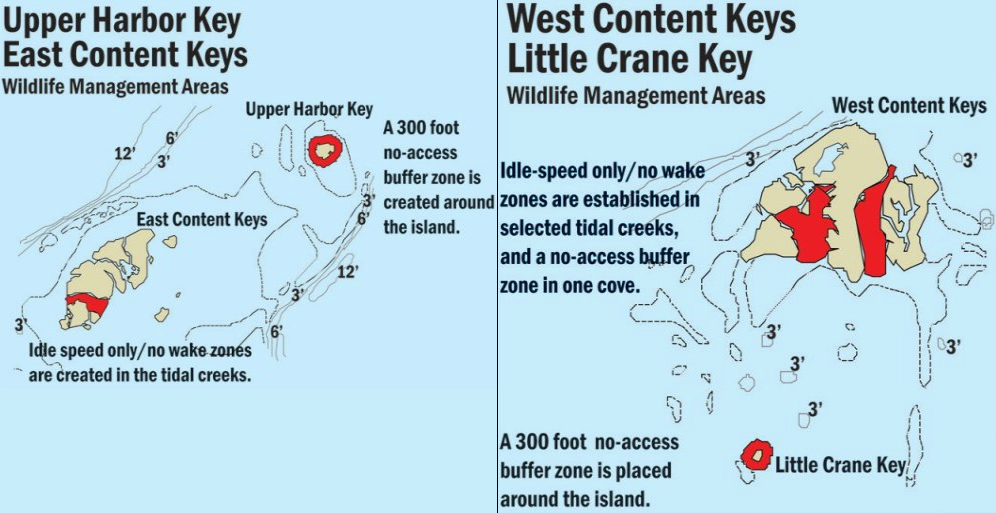
Content Keys |
Reef |
Novice |
24°47.830 N
81°29.330 W |
15' |
|
| |
The Content Keys are a group of small islands sitting in extremely
shallow water. This sanctuary is situated on the Gulf side between Marathon and Key West. During the 8 month of lobster season, which runs from August through
March, you'll see droves of people lobster fishing for their daily quota.
Markers - None.
Details - This small group of reefs doesn't benefit from a strong current so the visibility can be poor. Content Ledges is offshore of the Key and you'll find
numerous lobster under the ledges.
Marine Life - Plentiful lobster, stone crab, and red striped shrimp. Also larger coral heads, sea sponges, juvenile fish.
Recommended Certifications - Open Water, Advanced Open Water, Enriched Air (Nitrox), Boat, Drift, Peak Performance Buoyancy, Coral Reef Conservation. |
|
|
2 |
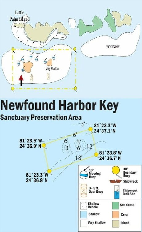
Newfound Harbor |
Reef |
Novice |
24°38.768 N
81°23.206 W |
6' |
|
| |
Newfound Harbor Keys is a chain of islands just south of Little
Palm Island that extends west from the east end of Big Pine Key. The small islands and their adjacent patch reefs are separated by very shallow water. It's so
shallow that the tiny Florida Key deer can easily travel from island to island in search of food, migrating back and forth to the Big Pine Key area.
Markers - Several mooring buoys.
Details - Shallow patch reef.
Marine Life - Yellowtail, grunts, large boulder and brain coral, star coral, angelfish, butterflyfish, grunts, surgeon fish, damselfish, wrasses, grunts, grouper,
blue tangs, parrotfish.
Recommended Certifications - Open Water, Advanced Open Water, Enriched Air (Nitrox), Boat, Drift, Peak Performance Buoyancy, Coral Reef Conservation.
|
|
|
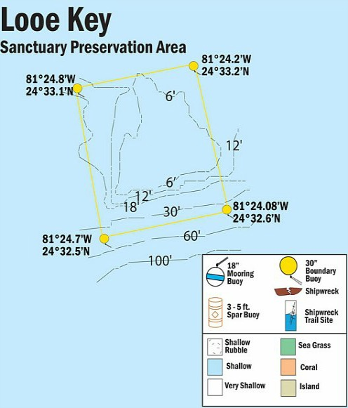
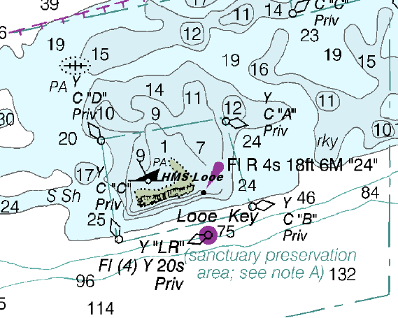
3 |
Looe Key Reef |
Reef |
Novice - Advanced |
24°32.939 N
81°24.031 W |
100' |
|
| |
This large, well formed spur and groove formation derives it's name
from a British Man of War which grounded here in 1744. The U-shaped reef is about 200 yards long and 800 yards wide and is made up of standard patch reefs and outer
banks.
Markers - Numerous buoys are scattered throughout the area.
Details - Light to moderate current. The coral reef is shallow but gets deeper at the outer edge where the depth drops off to about 100'. Sea grass is found
in the shallows and shark, stingrays, and sea turtle frequent these areas. The south end is the deepest at 30' to 40' depth then there is an undercut drop-off that
plummets almost to 100'.
Marine Life - Parrotfish, surgeonfish, barracuda, angelfish, grunts, yellowtail, wrasses, damselfish, blue tangs, grouper, nurse shark, sea whips, sea fans,
sea rods, anemones, large brain coral, star coral, elkhorn coral, fire coral, orange elephant ear sponges, brown tube sponges, mutton snapper, sea turtles,
stingrays.
Recommended Certifications - Open Water, Advanced Open Water, Enriched Air (Nitrox), Boat, Deep, Drift, Multi-Level, Peak Performance Buoyancy, Coral Reef
Conservation. |
|
|
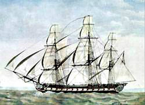
4 |
HMS Looe |
Wreck |
Novice |
24°32.700 N
81°24.500 W |
20' |
|
| |
The remains of the HMS Looe rests at Looe Key which was named after
the 44 gun, British man-of-war. Looe was towing the Billander Betty when she ran foundered on the reef in 1744. Captain Ashby Uttings ordered the crew to set fire
to the vessel to keep his warship from falling into the hands of the Spaniards and avoid being scavenged. Once ablaze, it wasn't long before it exploded, leaving
little behind.
Even though the crew of the warship and the towed Billander Betty were safe, they still had a major problem. They needed to avoid being
captured by their enemy, but the 3 small boats their ships carried, couldn't hold the size of the crew. Fortunately they were able to commandeer a nearby Spanish
sloop, and they departed to different ports.
The remains consist primarily of ballast stones, pieces of copper plating, a concrete block, and a coral
encrusted anchor. It's questionable as to whether all or any of these remains actually belong to these two vessels. Some of the remnants seem more appropriately
consistent to what would be found on a 19ath century merchant vessel.
Markers - None.
Details - Mostly disintegrated. Remnants include an anchor, ballast stone and copper plating.
Marine Life - Abundance of marine life makes this a very popular dive and snorkel site. Barracuda, jack, shark, angelfish, blue tang, different species of
coral, parrotfish, grunts, goliath grouper.
Recommended Certifications - Open Water, Advanced Open Water, Enriched Air (Nitrox), Boat, Drift, Peak Performance Buoyancy, Wreck, Coral Reef Conservation. |
|
|
|
|
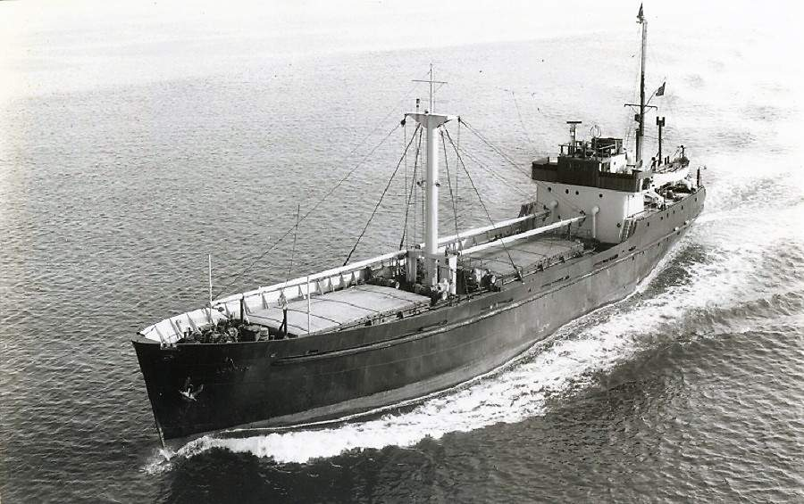
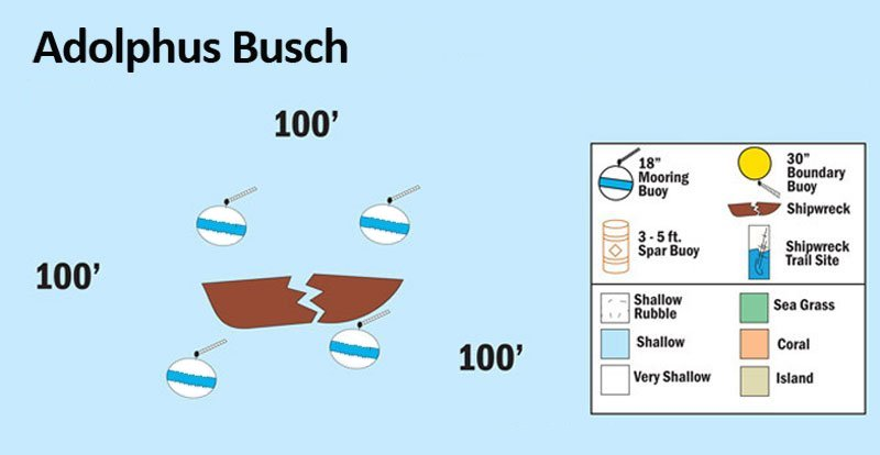
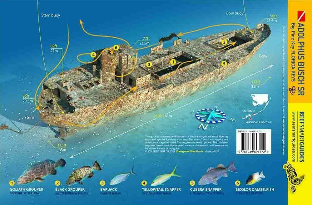
5 |
Adolphus Busch Sr. |
Wreck |
Intermediate - Advanced |
24°31.841 N
81°27.688 W |
110' |
|
| |
Built in Scotland in 1951, this short distance freighter served under different flags and names including
MV London 1951-1964, MV Windsor Trader 1964-1967, MV Topsail Star 1967-1988, MV Sophie Express 1988-1994, MV Princess Tarrah 1994-1995, MV Ocean Alley 1995-1998.
She also had a short stint as a prop in the 1957 movie, "Fire Down Under."
When a group of divers decided to purchase the ship in 1998 to serve as
a local artificial reef, Adolphus Busch Sr., who was an avid diver himself, provided the financial assistance they needed to complete the transaction. The group
decided to name the wreck Adolphus Busch Sr. in honor of him and his brewing company.
This 210' freighter now rests in an upright position at a depth
of 110 feet. The deck and wheelhouse are found at about 80 - 100 feet, and the ship's tower at 40 feet. The ship's bow and stern anchors are embedded into the ground
to help keep her stabilized, now a Monroe County and NOAA requirement. Plus the weight of her frame has settled the keel deep into the soft sand.
When
she was towed out to her final resting place, dynamite wasn't used to sink her because she was in protected water. Instead, 12 holes were cut into the hull, her
compartments were flooded, and she settled into her final position at 12:30 p.m., December 5, 1998. The dive quality of this wreck is superior because it lacks the
rips and tears that are common when detonation is used. The holes that were cut into her were planned, marked, and cleanly made. The fact that the cuts were made so
cleanly makes them excellent swim holes, and when diving this wreck, it's easy to pass through them.
Markers - 4 mooring buoys.
Details - The ship's tower comes within 40' of the surface. 12 large holes have been cut in the ship making for great swim throughs for divers. The ship is
intact and in upright position.
Marine Life - Large goliath grouper, moray eels, cleaner shrimp, rays, all varieties of tropicals including angelfish and parrotfish, snook, spanish mackerel,
cero mackerel, barracuda, grunts, jacks, tarpon, ocean sponges and coral.
Recommended Certifications - Open Water, Advanced Open Water, Enriched Air (Nitrox), Boat, Deep, Drift, Multi-Level, Peak Performance Buoyancy, Wreck,
Coral Reef Conservation. |
|
|
|
|
|
|
|
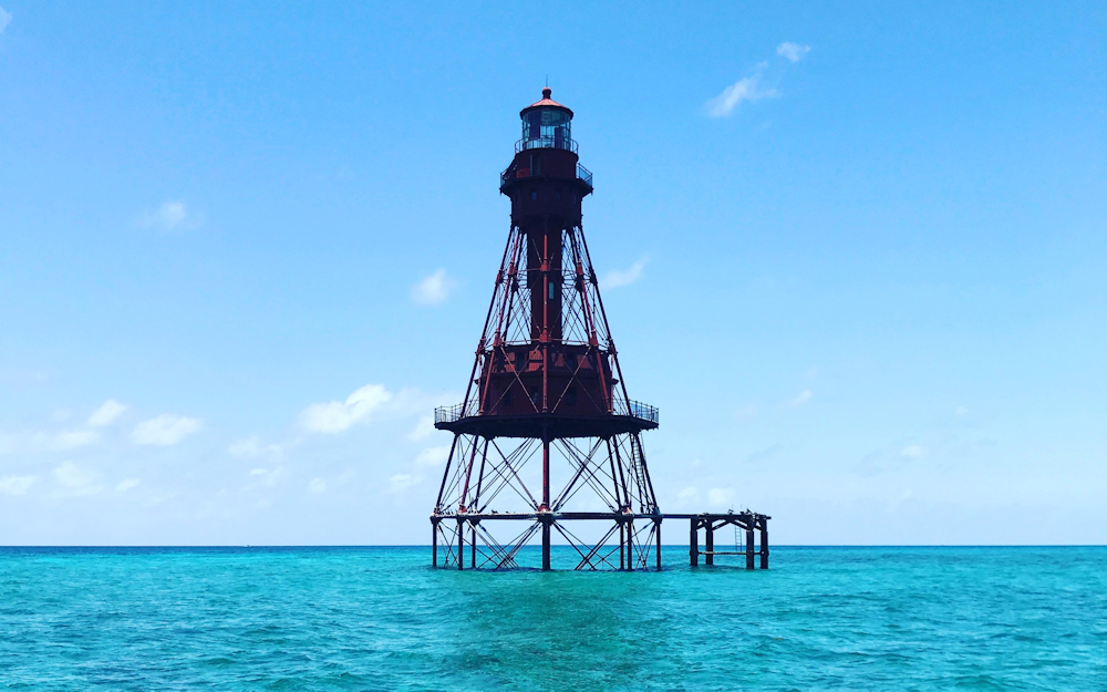
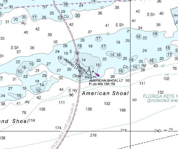
6 |
American Shoal |
Reef |
Novice - Advanced |
24°31.568 N
81°31.383 W |
109' |
|
| |
The American Shoal lighthouse was built in 1880 and was the
last of the lighthouses to be placed in the Florida Keys. Operational today, this lighthouse warns passing ships of their pending proximity to this beautiful,
and dangerous coral reef. In fact, this is considered to be one of the more dangerous reefs in the Florida Keys. Over the centuries, this reef has wrecked
numerous ships. When dive here, you should easily be able to discover scattered bits and pieces of their remains. Many of these remnants will be encrusted
with coral, while some will be partially buried in the sandy bottom. At the lighthouse, the water is the shallowest at 4 feet in depth. Further out, it drops
to a depth of 94 feet.
Markers - Lighthouse.
Details - Shallow at the lighthouse. Good spur and groove formation. Relatively close to Looe Key Reef but not as busy. There are also bits and pieces of
coral encrusted ship remnants scattered over the ocean floor from the many vessels that have wrecked here over the centuries.
Marine Life - Grouper, mangrove snapper, yellowtail, barracuda, nurse shark, moray eel, hogfish, coral heads, brain coral, purple sea fans, permit, blackfin
tuna and larger pelagic species such as sailfish are found at deeper levels.
Recommended Certifications - Open Water, Advanced Open Water, Enriched Air (Nitrox), Boat, Deep, Drift, Multi-Level, Peak Performance Buoyancy, Coral Reef
Conservation. |
|
|
|
|
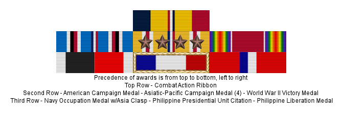
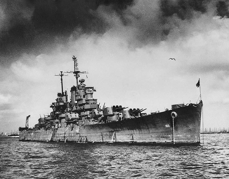
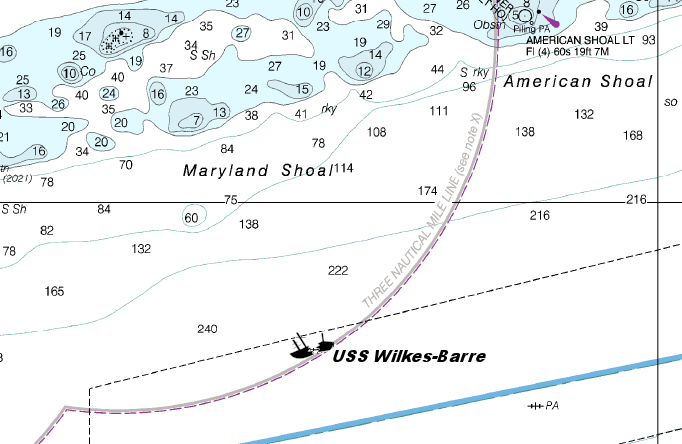
7 |
 |
Wreck |
Tech ONLY |
24°29.094 N
81°33.202 W |
250' |
|
| |
The USS Wilkes-Barre (CL-103) was built in
1942. She is 610 feet long with a 63 foot beam. Also known as the Willie Bee, she served at the very end of WW II in the Pacific, and eventually played a vital
role in the battle of Iwo Jima and the invasion of Okinawa.
After the war, the Wilkes-Barre served for three more years and received 4 battle
stars before being decommissioned in 1947. After sitting in reserve in Philadelphia for 25 years, the Navy decided to use her to test explosive ordnance. In
doing so, the Willie Bee was split into two sections and on May 12, 1972 the stern sank. On May 13, after additional explosives were employed, they managed to
scuttle the bow.
The stern of this massive ship is at a depth of 250 feet in an east - west upright position. Her superstructure can be reached
at a depth of 145 feet. The bow sits about 100 yards to the east on it's starboard side, at a depth of 200 to 250 feet.
Markers - None.
Details - Ship was split in half during a mission to test explosives. Due to the depth and distance separating the pieces, they're treated as separate
Key West dives. Machinery parts, radar and other equipment are found on the ship and in the surrounding sand. A gun turret is about 50' starboard off the bow.
Strong currents can be present and fishing line and nets litter the dive site.
Marine Life - Sperm whales, the seldom seen whale shark, a greater variety of shark species, swordfish, large goliath grouper, black grouper, scamp,
amberjack, speckled hind, marlin, manta rays, barracuda, margate, bonito, snapper, sailfish, oysters.
Recommended Certifications - Technical diving. |
|
|
|
|
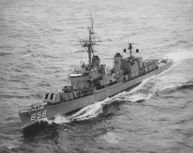
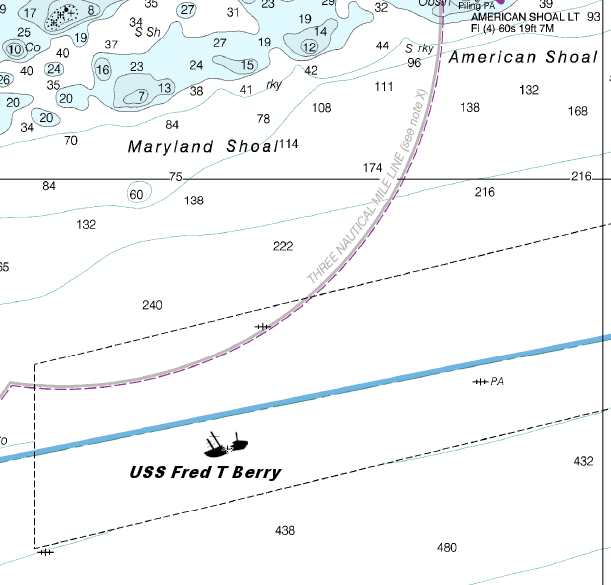
8 |
 |
Wreck |
Tech ONLY |
24°27.480 N
81°33.200 W |
370' |
|
| |
The USS Fred T. Berry (DD-858) was launched on January 28, 1945, by
Bethlehem Steel Co. in San Pedro, California; sponsored by Mrs. Fred T. Berry, widow of Commander Fred Thomas Berry; and commissioned on May 12, 1945, with Commander
N. J. Frank, Jr., in command. In 1950, she was reclassified as an Destroyer Escort.
Alerted for temporary duty in the Mediterranean at the opening of
the Korean War, Fred T. Berry sailed from Newport on July 5, 1950, and at the end of the summer, sailed on through the Suez Canal to join the 7th Fleet in the Far East.
She screened fast carriers launching strikes on targets in North Korea, and escorted the battleship Missouri (BB-63) to her bombardment duty at Hŭngnam during the
withdrawal from that port. Detached from Task Force 77 (TF 77) on February 5, 1951, Fred T. Berry sailed eastward to complete her circumnavigation of the world with
her return to Newport on March 14, 1951. During that trip, she earned 2 battle stars.
Her continued service throughout the years, even participating
in the early stages of the Vietnam War, she provided naval gunfire support. After crisscrossing the oceans numerous times, and visiting many ports of call, she was
given her final assignment in 1970. She was to serve as a DD Type Target Hull to determine the vulnerability of a ship.
After being properly prepped,
and relocated to her chosen destination, the Underwater Explosives Research Division ran an underwater explosive test. She was successfully sunk on May 14, 1972.
Today, her 390 foot long frame with a 41 foot beam, rests 370 feet below the ocean surface.
Markers - None.
Details - Shallow at the lighthouse. Good spur and groove formation. Relatively close to Looe Key Reef but not as busy. There are also bits and pieces of
coral encrusted ship remnants scattered over the ocean floor from the many vessels that have wrecked here over the centuries.
Marine Life - Minimal due to depth but different varieties of shark, snapper and grouper can be spotted.
Recommended Certifications - Technical diving. |
|
|
|
|
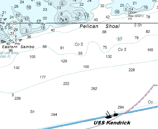
9 |
 |
Wreck |
Tech ONLY |
24°27.609 N
81°36.065 W |
325' |
|
| |
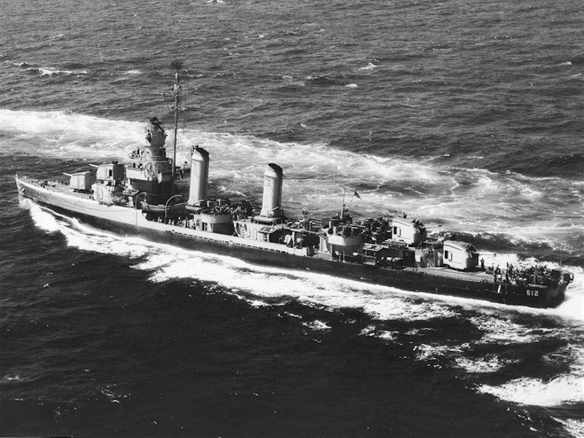
The USS Kendrick (DD-612) is a Bristol class destroyer commissioned
on September 12, 1942. She served in WW II earning 3 battle stars. As part of the Allied forces, she provided gunfire support to troops fighting against the enemy
Axis in Italy.
After crossing the Atlantic for her 4th time in 1943, on the night of September 2, a German torpedo bomber made a surprise attack on
Kendrick's starboard quarter. The plane flew in just 50 feet above the water and launched two torpedoes before it was shot down by the destroyer's gunners. One of
the torpedoes struck Kendrick's stern, damaging her rudder, steering compartment, and fantail, and killed one crew member. After temporary repairs, she was towed
back to New York. Upon completion of repairs, she made a round-trip escort cruise to the UK before sailing as a convoy escort in February 1944.
Arriving
at Oran, Algeria on March 5th, she prepared for patrol and screening operations, and joined the screen of the USS Philadelphia (CL-41). For nearly 3 months, the
destroyer repeatedly provided effective gunfire in support of ground troops advancing up the Italian boot. After Rome was liberated, she stood by to support the
Allied drive in northern Italy.
She sailed past Palermo on August 12th for the invasion of southern France. As a unit of Rear Admiral Morton Deyo's
American-French bombardment group, Kendrick gave direct fire support to the 36th Infantry Division storming the beaches on August 15th. She helped silence German
88mm guns on August 15-16, and bombarded gun emplacements and ammunition dumps at St. Madrier, France on August 25-26. Upon completion of her mission, the destroyer
steamed toward the United States, arriving at Boston, Massachusetts on September 19th.
In 1945, she spent 4 months performing air-sea rescue, escort
duty, fire support missions, and patrol duty in the Mediterranean as the war in Europe came to an end. She finally returned to Charleston, South Carolina on October
16th where she remained until she was decommissioned and joined the Atlantic Reserve Fleet at Orange, Texas, March 31, 1947.
On May 1, 1966, her name was
struck from the Navy List, and was then used in destruction tests at sea
on March 2, 1968.
Markers - None.
Details - Water is cold and current can be very strong, although occasionally it can be very minimal.
Marine Life - Brittle stars, shark, snapper, grouper, scamp, amberjacks.
Recommended Certifications - Technical diving. |
|
|
|
|
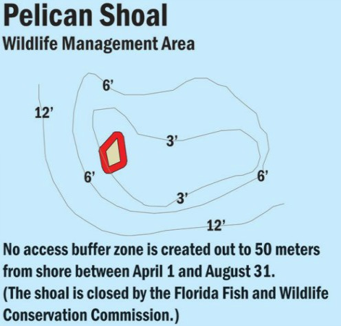
10 |
Pelican Shoal |
Reef |
Novice - Intermediate |
24°30.010 N
81°37.840 W |
36' |
|
| |
For centuries, Pelican Shoal was an important nesting area for
the roseate and bridled terns. The island was high enough that their nests stayed safe. However, all of that changed due to hurricanes in 2004 and 2005 that
decimated the island and all that was left was a pile of rubble. The birds haven't been back since. The area has now been designated a critical Wildlife
Management Area by the Florida Keys National Marine Sanctuary.
The coral reef itself is a less developed spur and groove formation than what
you would typically see in the area.
Markers - 4 mooring buoys, P-1 thru P-4.
Details - Area has been significantly reduced due to hurricane damage. Even though it's further out this is still a good dive site. The area also
has a tremendous amount of gamefish and tropical fish.
Marine Life - Barracuda, spiny lobster,, coral including elkhorn, brain, and staghorn, sea sponges including orange elephant sponges, brown tube sponges,
grouper, parrotfish, angelfish, damselfish, blue tangs, grunts, nurse shark, yellowtail, Queen conchs, butterflyfish.
Recommended Certifications - Open Water, Advanced Open Water, Enriched Air (Nitrox), Boat, Drift, Multi-Level, Peak Performance Buoyancy, Coral Reef Conservation. |
|
|
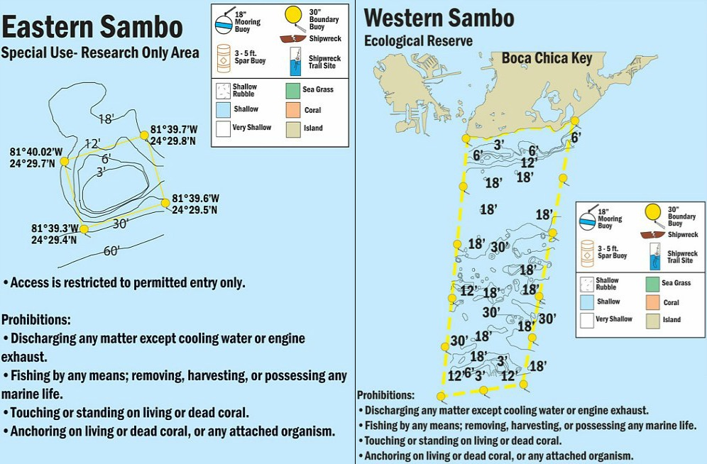
11 |
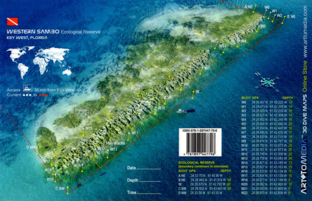
Sambo Reefs |
Reef |
Novice - Intermediate |
24°29.710 N
81°41.790 W |
60' |
|
| |
Sambo Reefs is a large system that's divided into three reef
regions - Eastern, Middle and Western that are separated by large sandy areas. The Eastern Sambo section is a good example of spur and groove reefs with numerous
ledges, and very healthy coral. The Middle Sambo section is surrounded by large white sandy areas which separate it from the Eastern and Western Sambo reefs.
This reef also has a more highly defined coral reef structure than the outer two. The Western Sambo section covers 9 nautical square miles and is 1 of the 2
Florida Keys National Marine Sanctuary Ecological Reserves.
GPS Coordinates:
Eastern: 24 29.50N, 081 39.80W
Middle: 24 29.71N, 081 41.79W
Western: 24 28.81N, 081 42.87W.
Markers
Eastern - Red channel marker #28 on east end.
Middle - None.
Western - Red channel marker with #30 on east end, Orange SPA buoys, yellow Restricted Area Only buoys, numerous mooring buoys.
Details - 3 separate healthy coral reef structures with a broad variety of tropical fish, coral and game fish. Numerous ledges where massive quantities of
larger spiny lobster are located. Large fields of brain coral and elkhorn, along with shipping remnants and the remains of a tugboat. Good underwater photography
site.
Marine Life - Anemones, crabs, starfish, sea cucumbers, sand dollars, sea urchins, rosy blennies, star coral, ocean sponges, large stands of rare elkhorn
coral, neon gobies, grunts, wrasses, blue tangs, queen conch, blue parrotfish, trumpet fish, large brain coral, angelfish, damselfish, striped parrotfish, rock
beauties, butter hamlets, sharpnosed puffers, rosy blennies, yellowtail, schoolmasters, grouper, hogfish, barracuda, snapper, lobster, nurse shark.
Recommended Certifications - Open Water, Advanced Open Water, Enriched Air (Nitrox), Boat, Drift, Multi-Level, Peak Performance Buoyancy, Coral Reef Conservation. |
|
|
|
|
|
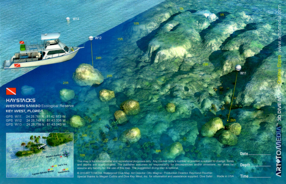
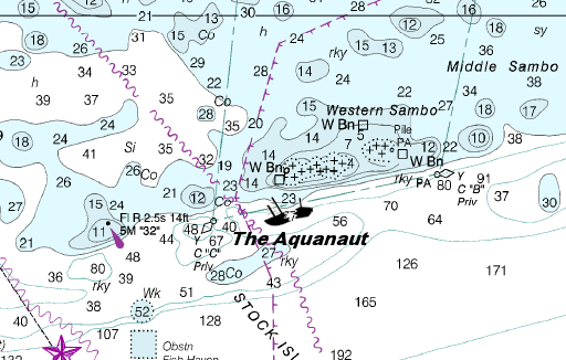
12 |
Aquanaut |
Wreck |
Intermediate - Advanced |
24°28.750 N
81°42.980 W |
75' |
|
| |
This vessel was once a working 55 foot long wooden tugboat belonging to Chet Alexander, who was responsible for
the sinking of the USS Amesbury as an artificial reef. Originally, the Aquanaut sank in shallower water. After determining that refloating and rebuilding her was not
cost effective, Alexander realized she would be more useful to sea life if she were towed out to deeper waters. After doing all the prep work, he towed her out to sea.
Today, she sits close to the gulf stream so visibility is very good and the current can be strong at times. This is a very good site for underwater
photographers thanks to the visibility.
Markers - None.
Details - Broken up and scattered tugboat remains.
Marine Life - Spiny oysters, crab, spiny lobster, spotted eagle rays, yellowtail, mahogany snappers, shrimp, stingray, angelfish, grunts, grouper.
Recommended Certifications - Open Water, Advanced Open Water, Enriched Air (Nitrox), Boat, Drift, Multi-Level, Peak Performance Buoyancy, Wreck,
Coral Reef Conservation. |
|
|
|
|
13 |
Toppinos Reef |
Reef |
Novice |
24°28.430 N
81°42.970 W |
25' |
|
| |
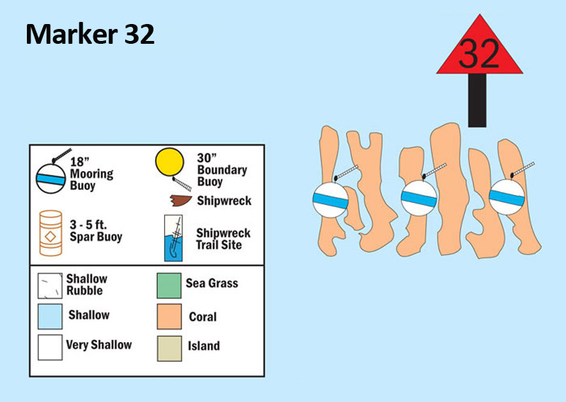
Toppinos Reef has gone by different names over the years including
Marker Reef #1. That number has been changed, and for those who prefer to call it by it's marker name, it's now Red 32 or Marker Reef #32. The navigation marker
has a light, so this makes a good dive trip for anyone scuba diving at night.
Markers - T1 - T3 mooring buoys.
Details - Standard spur and groove. Good night dive site. Very pretty and excellent photography site.
Marine Life - Sea turtles, grunts, butterflyfish, nurse shark, blue tangs, damselfish, green moray eel, very tall coral fingers rising 8 - 15', yellowtail.
Recommended Certifications - Open Water, Advanced Open Water, Enriched Air (Nitrox), Boat, Drift, Peak Performance Buoyancy, Coral Reef Conservation. |
|
|
14 |
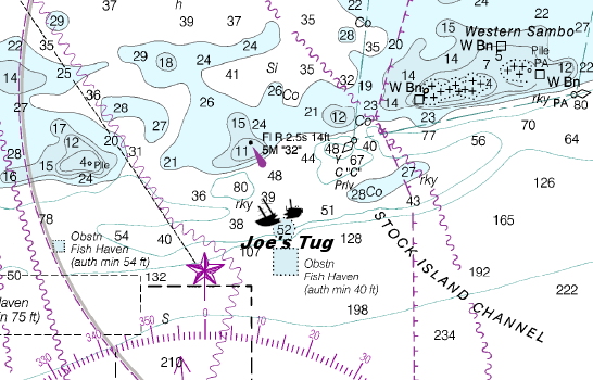
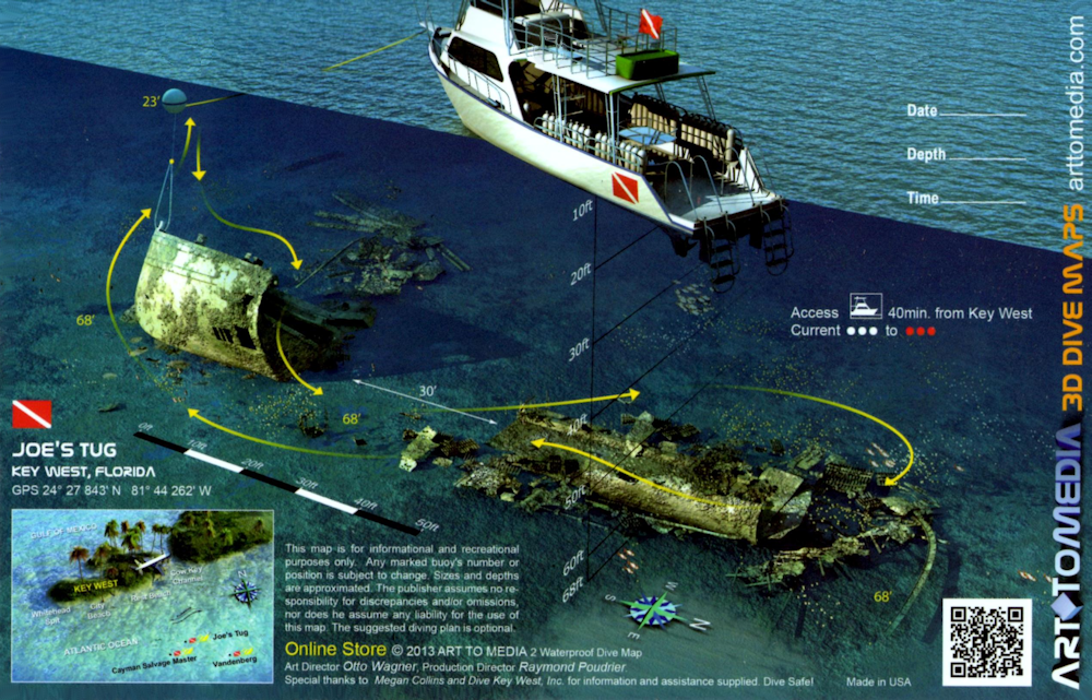
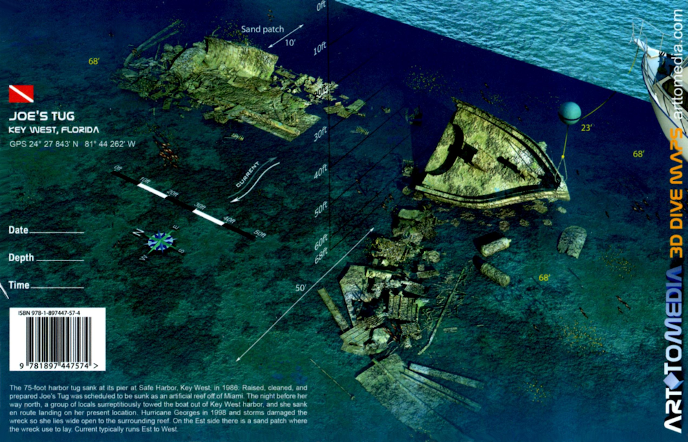
Joe's Tug |
Wreck |
Intermediate - Advanced |
24°27.850 N
81°44.270 W |
65' |
|
| |
This wreck also goes by a number of different names, including Tim's Tug and Joe's Wreck. First, Joe's Wreck
was not what her name described. She was in fact a 75 foot steel hulled shrimp boat. Second, she sank while in Key West harbor, and was eventually refloated, cleaned
and prepared for scuttling. However, like so many other vessels prepped to be an artificial reef, she never ended up at her intended destination. But unlike those
wayward vessels, she didn't simply sink before reaching her final resting place, she was stolen.
Late on the evening before her scheduled departure for
Miami, unknown suspects towed her out of a Key West harbor. En route to their mystery destination, she sank in about 65 feet of water. No one really knows for sure who
took Joe's Tug from the Key West harbor, and likely we never will.
This old vessel suffered considerable damage after Hurricane George swept through the area in
1998. The strong winds and waves eventually broke the old shrimp boat apart, and the remnants of the bow and stern are positioned about 30 feet apart. The ship sits
upright, so even though the wheelhouse has decayed somewhat, you can easily access it along with the aft deck and hull.
Markers - None.
Details - Remains are upright but have been torn and somewhat dispersed due to hurricanes and weather. Bow and stern are approximately 35' apart.
Marine Life - Sea sponges, eels, numerous tropical fish, yellowtail, barracuda, goliath grouper, coral.
Recommended Certifications - Open Water, Advanced Open Water, Enriched Air (Nitrox), Boat, Drift, Multi-Level, Peak Performance Buoyancy, Wreck,
Coral Reef Conservation. |
|
|
|
|
|
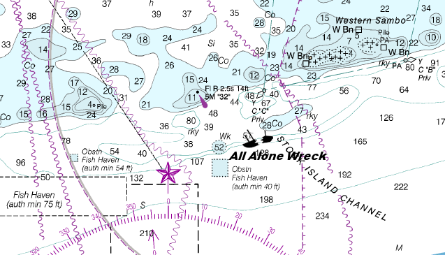
15 |
All Alone Wreck |
Wreck |
Intermediate - Advanced |
24°27.330 N
81°43.420 W |
90' |
|
| |
This 70 foot long tugboat sits on 10 Fathom Ledge. Her hull is split
open which makes her the perfect artificial reef. The current can be somewhat strong at this site, so be prepared.
Markers - None.
Details - Stronger current. Tug's hull is split open.
Marine Life - Barracuda, sea sponge, snook, tropical, shark, eel, coral, and grouper.
Recommended Certifications - Open Water, Advanced Open Water, Enriched Air (Nitrox), Boat, Drift, Multi-Level, Peak Performance Buoyancy, Wreck,
Coral Reef Conservation. |
|
|
16 |
 |
Wreck |
Advanced |
24°27.279 N
81°43.926 W |
110' |
|
 |
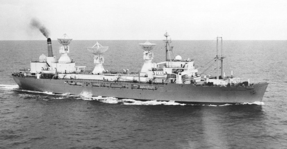
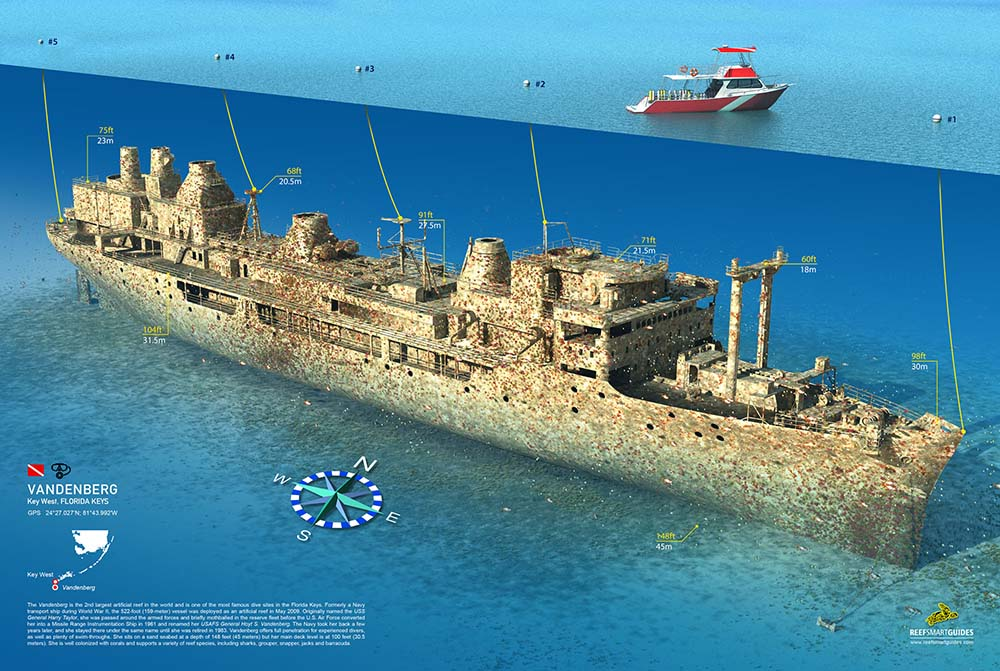
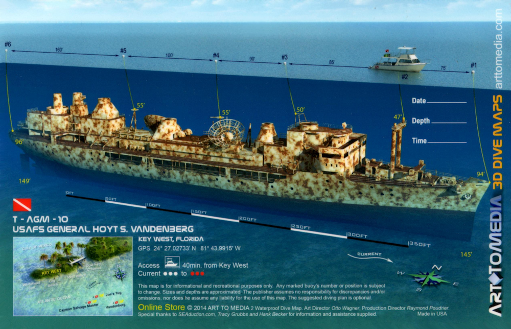
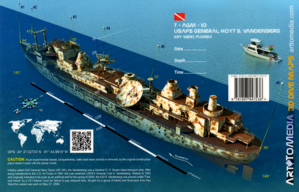
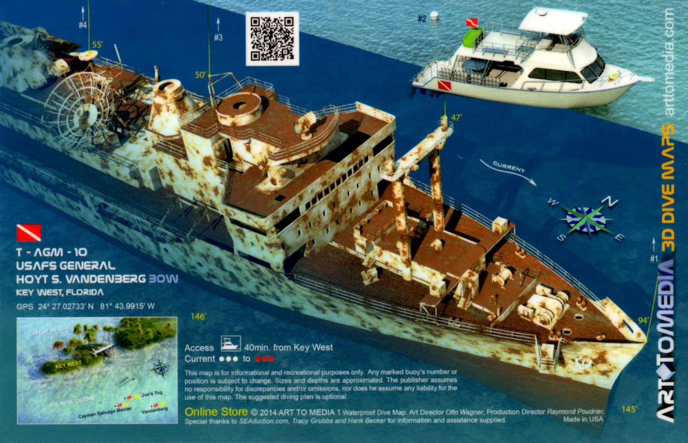
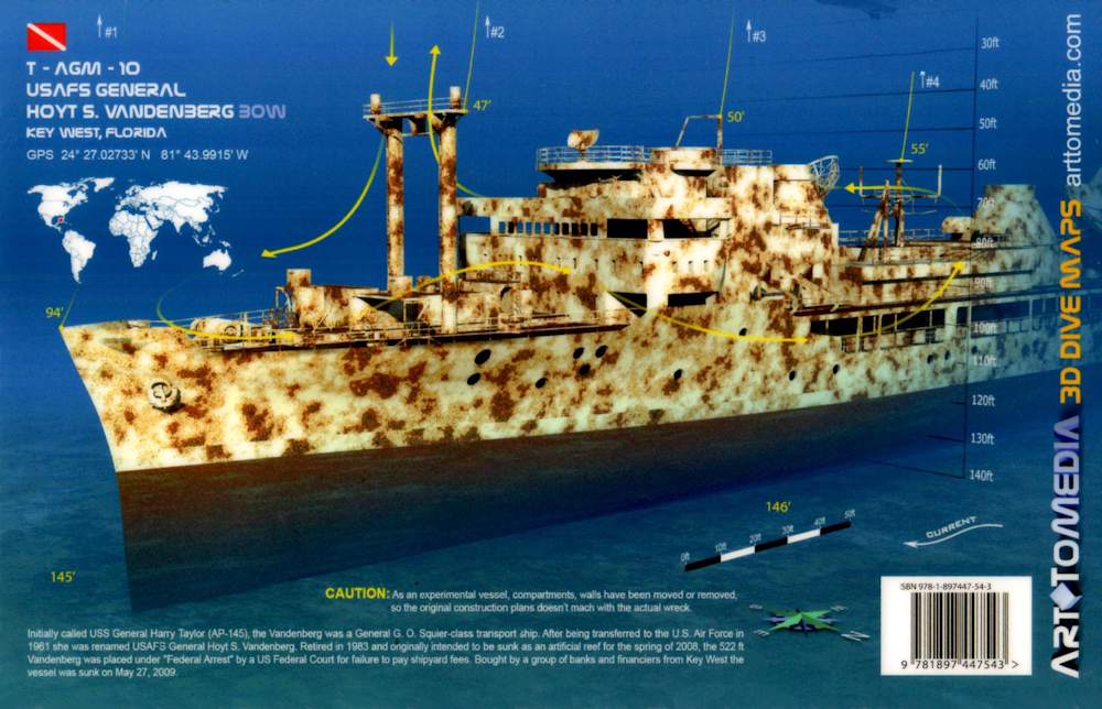
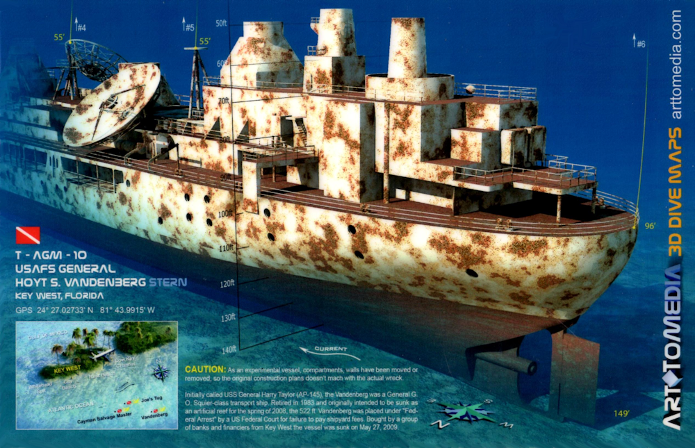
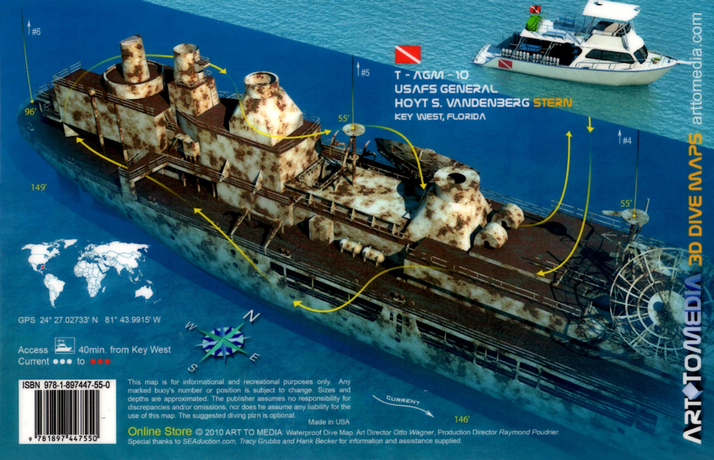
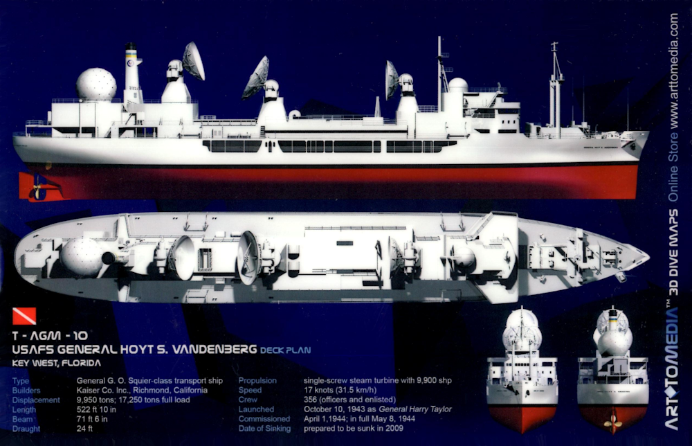
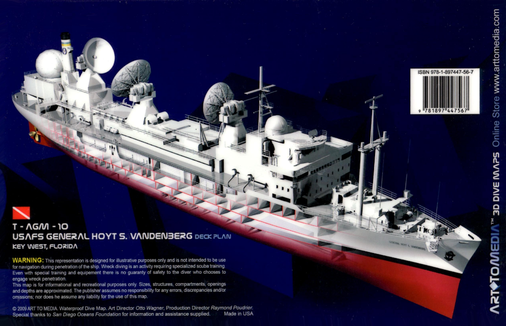
Built in 1943, the Vandenberg was originally named USS General Harry
Taylor (AP-145) before her debut launch on October 10, 1943. Capable of speeds upwards of 17 knots, this massive ship carried 200 men and her 636 compartments
ensured she had all the amenities of home. Her facilities included a theater, laundry, lounges, storerooms, staterooms, hospital, offices, rec areas, and more. With
a massive length of 523 feet, she has a 71 foot beam and stands 10 stories high, she could reach speeds of 17 knots. She had a crew of 356 officers and enlisted and
could carry as many as 3,224 troops.
Purchased by the Navy on March 29, 1944 she spent a number of years transporting men, supplies, and equipment around the world during World War II and
after. In 1961 she became the property of the United States Air Force and this is when she was given her famous name of USAFS General Hoyt S. Vandenberg.
On July 1, 1964, she was returned to the Navy and became the USNS General Hoyt S. Vandenberg (T-AGM-10) serving as a missile range instrumentation ship where she
was deployed to Senegal as part of the Global Atmospheric Research experiment. Her duties included tracking and analyzing the reentry bodies of ballistic missiles
in their terminal phase of test flights. She spent the remainder of her military career tracking missiles and space craft that were reentering the atmosphere until
1983 when she retired.
From here she was transferred to the Maritime Administration and on February 13, 2007, the approval to place her as a Florida Keys
artificial reef was finally received. However, before her sinking, the USNS Vandenberg had time to perform one final duty. She served as the starring prop in the
horror movie "Virus" where she portrayed a Russian vessel. On May 27, 2009, the Vandenberg became the second largest artificial reef in the world when she was
scuttled off Key West, sinking in 1 minute and 44 seconds.
Markers - 5 surface buoys and 1 submerged buoy.
Details - Full upright position. 524 feet long, 71.6 foot beam, 10 stories high.
Marine Life - Goliath grouper, eel, shark, snapper, barracuda, stony and gorgonian coral, damselfish, angelfish, mackerel, sea sponges, hogfish.
Recommended Certifications - Open Water, Advanced Open Water, Enriched Air (Nitrox), Boat, Deep, Drift, Multi-Level, Peak Performance Buoyancy, Wreck,
Coral Reef Conservation.
|
|
|
|
|
|
|
|
|
|
|
|
|
|
|
|
|
|
|
17 |
9 Foot Stake |
Reef |
Novice |
24°28.294 N
81°45.855 W |
30' |
|
| |
This reef diving site is named after a piece of metal stuck
in the shallow NE corner of the reef. 9 Foot Stake is perhaps one of the prettier coral reefs to snorkel or dive. This shallow patch reef is teeming with an
incredible variety of tropical and game fish. It also boasts some larger pieces of brain coral, and a good spectrum of both stony and gorgonian coral.
Markers - 9FT1 and 9FT2 buoys.
Details - The typical spur and groove formation includes metal debris which are remnants of an old, smaller lighthouse and these pieces have settled
on top of the coral patches. Good second dive after going deep on the Cayman Salvager.
Marine Life - Anemones, barracuda, hogfish, urchins, lobsters, moray eels, grouper, grunts, jacks, mackerel, goatfish, crabs, large brain coral, bristle stars,
sea turtles, nurse and hammerhead sharks, eagle rays, yellowtail, blue chromis, grunts, spiny lobster, stony and gorgonian coral, queen conch.
Recommended Certifications - Open Water, Advanced Open Water, Enriched Air (Nitrox), Boat, Drift, Peak Performance Buoyancy, Coral Reef Conservation. |
|
|
18 |
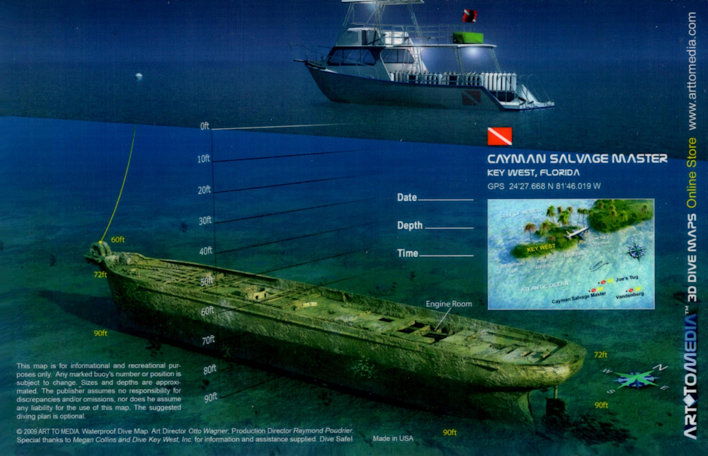
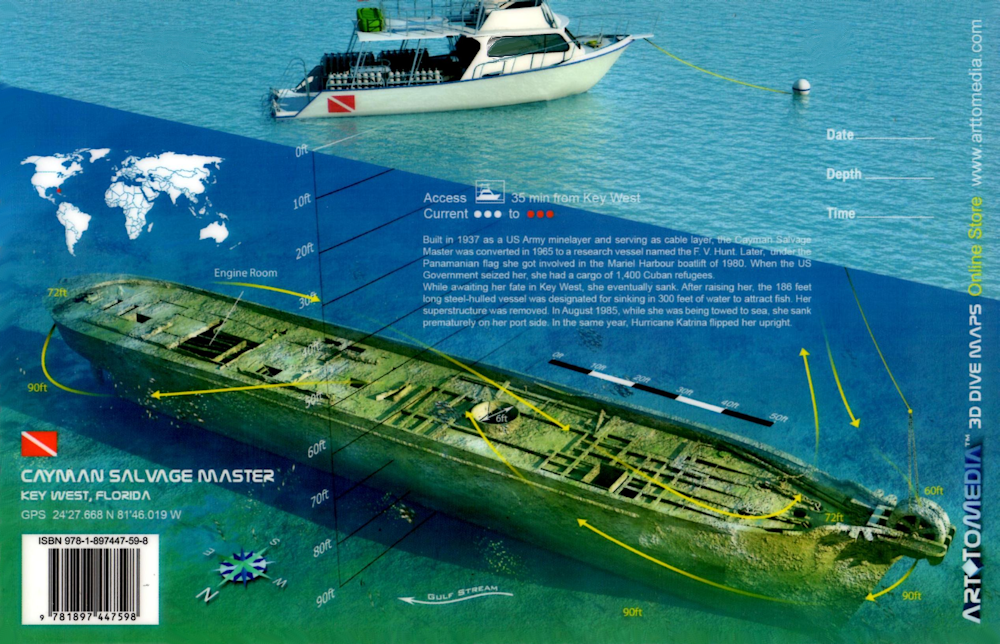
Cayman Salvage Master |
Wreck |
Intermediate - Advanced |
24°27.210 N
81°45.980 W |
93' |
|
| |
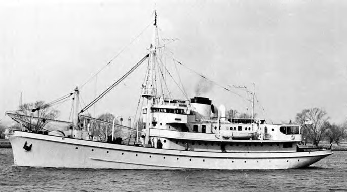
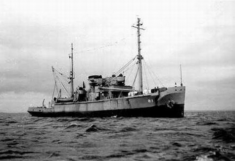
Built in 1936-37 for the U.S. Army Quartermaster Department by the Pusey and Jones Shipbuilding Co, Wilmington,
DE and launched on July 22, 1937. USAMP Lt. COL. Ellery W. Niles was named in honor of Lt. Col. Ellery W. Niles, a former mine planter commander and the Chief of War
Plans in the Office of the Chief of Coast Artillery when he passed away in 1929. The ship was commissioned on January 7, 1938, and based out of Fort Monroe, VA.
In 1938, she sailed through the Panama Canal on her way to California for training in San Diego. From June-August 1940, she installed the wartime minefields
that protected the Panama Canal zone during WWII. After the war, she was decommissioned and sold where she served as an acoustical research ship in the Bahamas and
was renamed R/V F.V. Hunt. She was then sold again being named the Cayman Salvage Master.
It was during this period in history that is referred to as
the Mariel boatlift. This event took place between April 15 and October 31, 1980, at Mariel Harbor in Cuba. It was a mass exodus of Cubans bound for the United States,
and these numbers included criminals and mental patients. While on one of her illegal missions, the ship was seized by the United States government and 1,400 Cuban
refugees were discovered on board. She was then towed to Key West where she inexplicably sank a few days later at the dock.
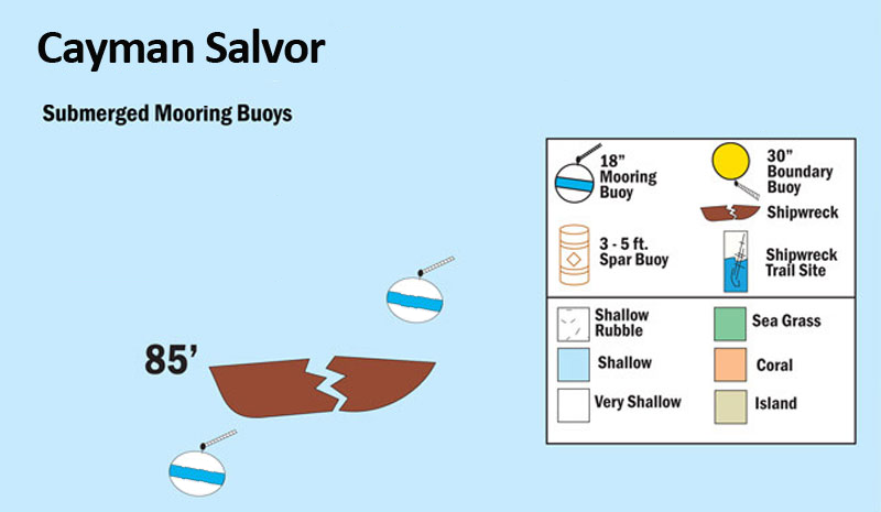
In 1985 she was refloated
with the intent of transforming her into an artificial reef. Her superstructure was removed, and she was properly cleaned. Doors, cables, wires and other entanglements
were removed from her frame, and holes were blasted in her hull. As the Cayman Salvor was being towed to her final resting place in the Atlantic, the cables attached to
her snapped. Instead of reaching her intended destination of 300 feet, she sank in 90 feet of water. When she finally settled, she was positioned on her portside.
Later, in 2005, the strong surge from Hurricane Katrina that obliterated New Orleans and the Mississippi coast, repositioned the vessel into her current
upright position. Today, the Cayman Salvage Master is considered one of the more popular sites since she sits at a reasonable diving depth, in upright and good condition.
There are 3 bicycles on board, no doubt left behind by several of the Mariel boatlift Cuban refugees. There's also a payphone, a cable spool and pulley on the bow.
Markers - Buoy marks the dive spot.
Details - This site is near the Gulf stream so currents can be strong. Ship sits upright and is mostly intact except for super structure which has been stripped
clean to make a better habitat for marine life.
Marine Life - Snook, goliath grouper, nurse shark, moray eel, grouper, bar jacks, barracuda, silversides, permit.
Recommended Certifications - Open Water, Advanced Open Water, Enriched Air (Nitrox), Boat, Drift, Multi-Level, Peak Performance Buoyancy, Wreck,
Coral Reef Conservation. |
|
|
|
|
|
|
|
19 |
 |
Wreck |
Tech ONLY |
24°26.212 N
81°46.127 W |
185' |
|
| |
Built in California, and launched April 24, 1943, the
USS Curb (ARS-21) was a 213 foot Diver-class rescue and salvage ship. Commissioned by the Navy during World War II, she was responsible for towing and
assisting damaged vessels and bringing them to a safe port. On December 20, 1946, she was decommissioned in Orange, Texas and in May of 1947 she was
loaned to a commercial salvage firm where she also worked as a cable layer.
She eventually was returned to the Navy and laid up as part
of the Reserve Fleet. On April 30, 1981 the Curb was removed from the Naval Register and on February 23, 1982 she was scrapped, prepared for scuttling
and was eventually sunk November 23, 1983 as an artificial reef.
Markers - None.
Details - She sits upright on ocean floor. Diving into the wreck is easy with access to compartments, but poses some hazards due to silt, some
upright structures, and excessive fishing lines, netting, and lures. 3 winches sit at the bow.
Marine Life - Tarpon, goliath grouper, snapper, large assortment of tropicals, hogfish, shark, cobia, pompano, cigar minnows, coral.
Recommended Certifications - Technical diving. |
|
|
|
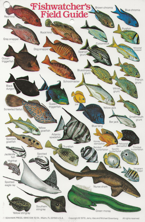
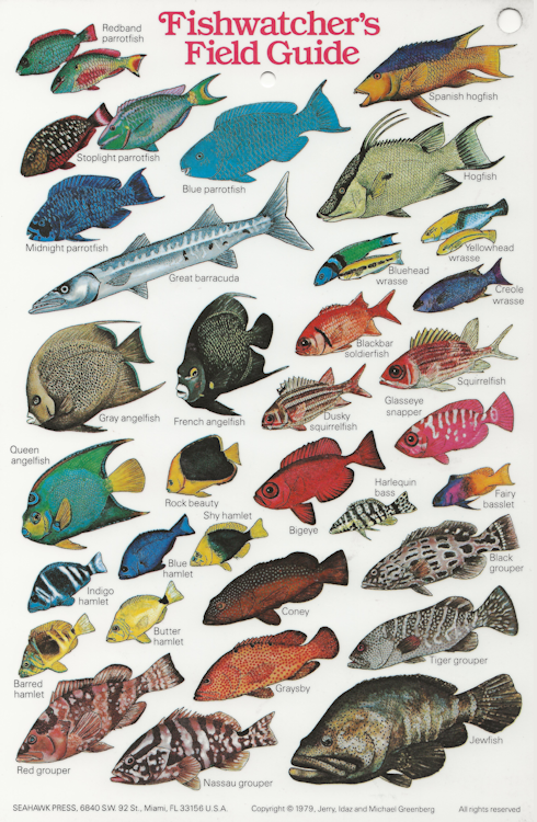
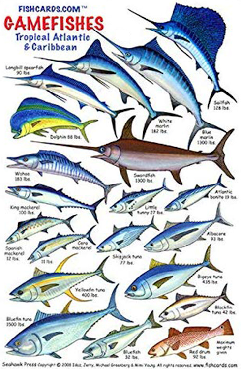
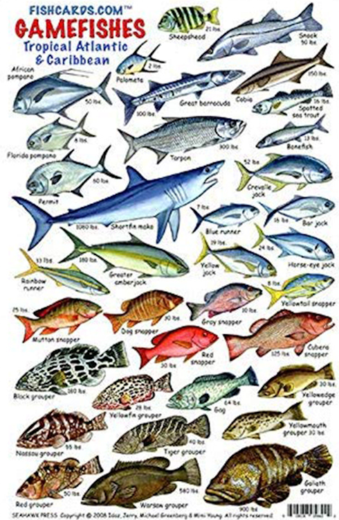
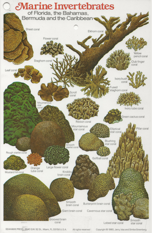
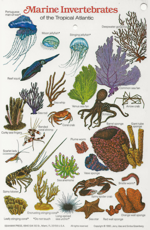
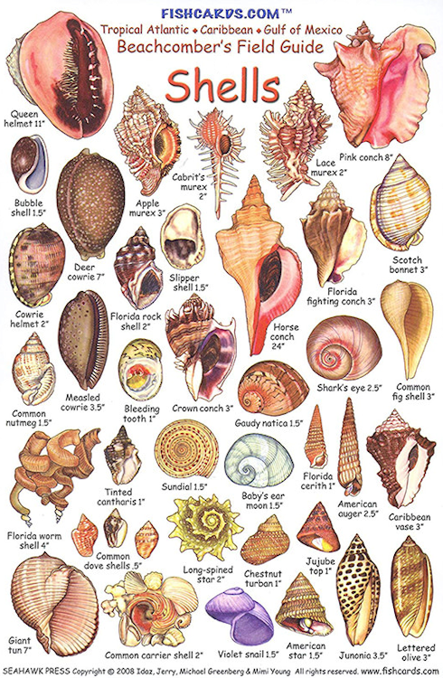
Reef and Fish Cards |
| Since there are thousands of different species of fish and coral, these ID cards will help you identify what you see under the ocean. |
|
|
|
|
|
|
|
|
|
|
|
|